File:Schwetzinger Hardt - Dünen.jpg
Jump to navigation
Jump to search
Size of this preview: 741 × 600 pixels. Other resolutions: 297 × 240 pixels | 593 × 480 pixels | 872 × 706 pixels.
Original file (872 × 706 pixels, file size: 232 KB, MIME type: image/jpeg)
Captions
Captions
Add a one-line explanation of what this file represents
Summary
[edit]
| Description |
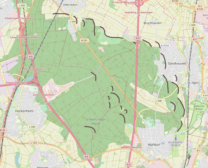
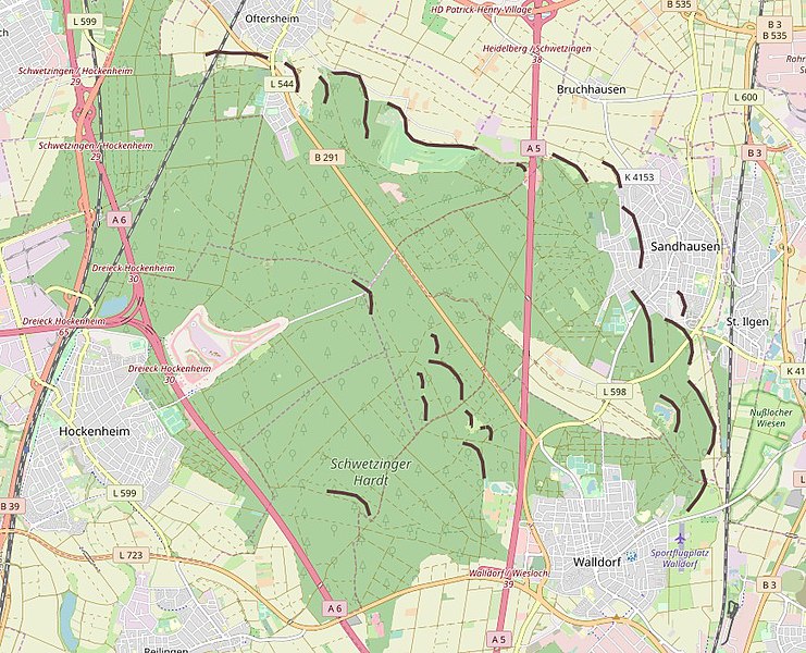
Deutsch: Lage der Binnendünen in der Schwetzinger Hardt - nur die markantesten Erhebungen sind markiert. Deutlich wird aber auf Anhieb dass sie alle nordöstlich ausgerichtet sind, da die Hauptwindrichtung seit jeher aus südwesten kommt (Grundlage der Markierungen TK25 - 6617 Schwetzingen) |
| Date | |
| Source | Open Street Map |
| Author | OpenStreetMap contributors (edited by anro) |
Licensing
[edit]
| Description |
This map was created from OpenStreetMap project data, collected by the community. This map may be incomplete, and may contain errors. Don't rely solely on it for navigation. |
| Date | (see file history) |
| Source | You may find a page on the OpenStreetMap wiki page for Wingertsbuckel |
| Creator |
OpenStreetMap contributors |
| Permission (Reusing this file) |
OpenStreetMap data and maps are licensed under the Creative Commons Attribution-ShareAlike 2.0 license (CC-BY-SA 2.0). This file is licensed under the Creative Commons Attribution-Share Alike 2.0 Generic license.
|
| Georeferencing | If inappropriate please set warp_status = skip to hide. |
File history
Click on a date/time to view the file as it appeared at that time.
| Date/Time | Thumbnail | Dimensions | User | Comment | |
|---|---|---|---|---|---|
| current | 21:24, 7 March 2019 | | 872 × 706 (232 KB) | AnRo0002 (talk | contribs) | {{Information |Description={{de|Lage der Binnendünen in der Schwetzinger Hardt}} |Source=[http://www.openstreetmap.org/ Open Street Map] |Author=OpenStreetMap contributors (edited by anro) |Date=2019-03-07 |Permission= |other_versions= }} == {{int:license-header}} == {{OpenStreetMap |odbl=no |name=Wingertsbuckel}} 00 |
You cannot overwrite this file.
File usage on Commons
The following 3 pages use this file:
File usage on other wikis
The following other wikis use this file:
- Usage on de.wikipedia.org