File:Schnitt-Schachtanlage Asse.svg
Jump to navigation
Jump to search

Size of this PNG preview of this SVG file: 667 × 600 pixels. Other resolutions: 267 × 240 pixels | 534 × 480 pixels | 854 × 768 pixels | 1,139 × 1,024 pixels | 2,278 × 2,048 pixels | 1,458 × 1,311 pixels.
Original file (SVG file, nominally 1,458 × 1,311 pixels, file size: 88 KB)
Captions
Captions
Add a one-line explanation of what this file represents
Summary
[edit]
| Description |
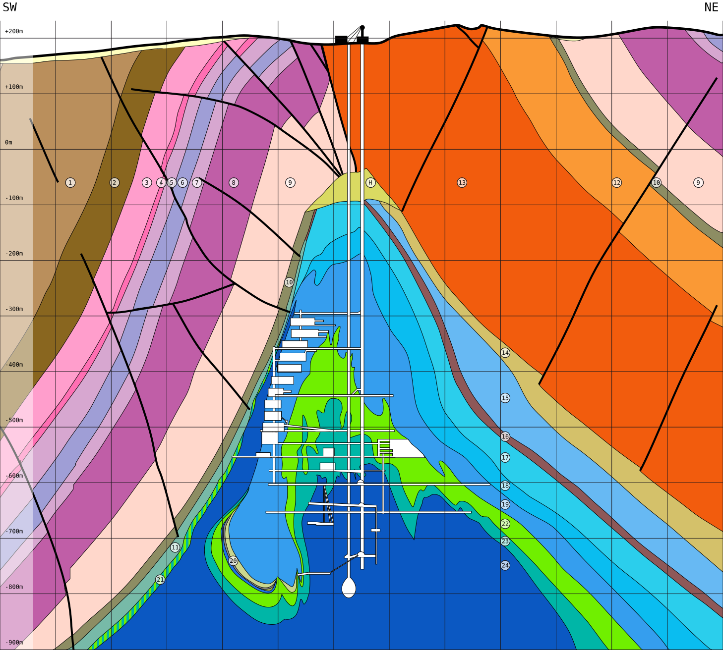
Deutsch: Geologische Schnittzeichnung durch den Asse-Salzsattel und das Grubengebäude der Schachtanlage Asse, nach Thömmes & Gömmel (2004)[1] und Szymaniak & Schäfer (2002)[2] Legende
English: Geological cross section of the Asse salt anticline including the mine workings of the Asse waste disposal testing facility (Schachtalage Asse), after Thömmes & Gömmel (2004)[1] and Szymaniak & Schäfer (2002)[2]
|
| Date | |
| Source | Own work |
| Author |
Benedikt.Seidl revised by Gretarsson |
Licensing
[edit]
I, the copyright holder of this work, hereby publish it under the following licenses:

|
Permission is granted to copy, distribute and/or modify this document under the terms of the GNU Free Documentation License, Version 1.2 or any later version published by the Free Software Foundation; with no Invariant Sections, no Front-Cover Texts, and no Back-Cover Texts. A copy of the license is included in the section entitled GNU Free Documentation License. |
This file is licensed under the Creative Commons Attribution-Share Alike 3.0 Unported, 2.5 Generic, 2.0 Generic and 1.0 Generic license.
- You are free:
- to share – to copy, distribute and transmit the work
- to remix – to adapt the work
- Under the following conditions:
- attribution – You must give appropriate credit, provide a link to the license, and indicate if changes were made. You may do so in any reasonable manner, but not in any way that suggests the licensor endorses you or your use.
- share alike – If you remix, transform, or build upon the material, you must distribute your contributions under the same or compatible license as the original.
You may select the license of your choice.
File history
Click on a date/time to view the file as it appeared at that time.
| Date/Time | Thumbnail | Dimensions | User | Comment | |
|---|---|---|---|---|---|
| current | 14:24, 22 April 2018 | | 1,458 × 1,311 (88 KB) | Gretarsson (talk | contribs) | viewbox-Parameter leicht verändert und Angaben zur Schnittlage (Himmelsrichtungen) hinzugefügt |
| 21:46, 19 April 2018 |  | 1,458 × 1,271 (87 KB) | Gretarsson (talk | contribs) | Geometrie leicht korrigiert; Farben gemäß geologischer Gepflogenheiten geändert; Nummerierung ergänzt und so angepasst, dass 1) gleiche Schichten nicht zwei verschiedene Nummern tragen und 2) die Nummerierung der stratigraphischen Abfolge entspricht (wenngleich invers) | |
| 20:09, 15 April 2010 |  | 1,458 × 1,291 (46 KB) | Benedikt.Seidl (talk | contribs) | schachtanlage angepasst, nummern und raster hinzugefügt. | |
| 19:10, 7 April 2010 |  | 1,443 × 1,413 (34 KB) | Benedikt.Seidl (talk | contribs) | {{Information |Description={{de|1=Schnitt Schachtanlage Asse}} |Source=von mir nachgezeichnete version von [http://www.endlager-asse.de/cae/servlet/contentblob/611910/poster/37270/schnitt.jpg] und [http://www.aufpassen.org/fachtagung01/HEFOLIE8.JPG] |Auth |
You cannot overwrite this file.
File usage on Commons
The following page uses this file:
File usage on other wikis
The following other wikis use this file:
- Usage on de.wikipedia.org
- Usage on fr.wikipedia.org
- Usage on it.wikipedia.org
- Usage on ja.wikipedia.org
Metadata
Categories:
- Schachtanlage Asse
- Salt domes of Germany
- Geology of Lower Saxony
- Geological cross sections of Germany
- Zechstein - stratigraphy
- Triassic geology of Germany
- Salt domes
- Unterer Muschelkalk
- Mittlerer Buntsandstein - stratigraphy
- Unterer Buntsandstein - stratigraphy
- Muschelkalk - stratigraphy
- Anhydrite (rock) in Germany
- Mittlerer Keuper
- Unterer Keuper
- Halite in Germany