File:Schloss Zehista 1 und 2.jpg
Original file (6,016 × 4,000 pixels, file size: 7.84 MB, MIME type: image/jpeg)
Captions
Summary
[edit]DescriptionSchloss Zehista 1 und 2.jpg |
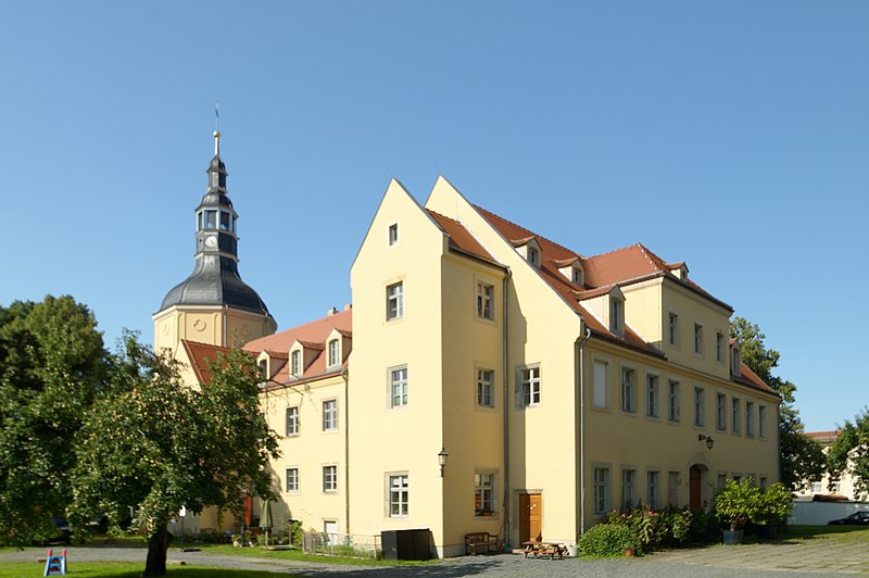
Deutsch: Rittergut-Schloss Zehista 1 und 2, Pirna, Sachsen, Hofansicht des Schlosses aus Südwesten, 2021.
Der Ort wurde erstmals 1355 als Zceyst erwähnt. Das Gut war 1458 Vorwerk und 1551 Rittergut. Obristleutnant Johann Siegmund von Liebenau, der 1654 zum Befehlshaber der sächsischen Artillerie und Oberkommandant aller Landesfestungen aufsteigen sollte, kaufte 1651 das Rittergut Zehista und begann sogleich, den Herrensitz repräsentativ auszubauen und das noch vorhandene Schloß zu errichtet. Die Rittergutsbesitzer wechselten seither häufig. 1736 kam das Gut an den kursächsischen Oberstallmeister Johann Adolf von Brühl. Unter seiner Herrschaft wurde der wuchtige Schloßturm errichtet, in dem 1742 im ersten Stock eine kleine Schloßkirche eingeweiht wurde. Letzter Besitzer vor der Enteignung war Egon-Ferdinand Graf von Rex. In der DDR-Zeit diente der Renaissancebau jahrzehntelang als Wohnhaus. |
Date | |
Source | Own work |
Author | VSchagow |
Camera location | 50° 56′ 13.96″ N, 13° 55′ 24.25″ E | View this and other nearby images on: OpenStreetMap | 50.937210; 13.923403 |
---|
This image was uploaded as part of Wiki Loves Monuments 2023.
Afrikaans ∙ Alemannisch ∙ azərbaycanca ∙ Bahasa Indonesia ∙ Bahasa Melayu ∙ Bikol Central ∙ bosanski ∙ brezhoneg ∙ català ∙ čeština ∙ Cymraeg ∙ dansk ∙ davvisámegiella ∙ Deutsch ∙ eesti ∙ English ∙ español ∙ Esperanto ∙ euskara ∙ français ∙ Frysk ∙ Gaeilge ∙ galego ∙ hrvatski ∙ Ido ∙ italiano ∙ latviešu ∙ Lëtzebuergesch ∙ Malagasy ∙ magyar ∙ Malti ∙ Nederlands ∙ norsk ∙ norsk nynorsk ∙ norsk bokmål ∙ oʻzbekcha ∙ polski ∙ português ∙ português do Brasil ∙ română ∙ shqip ∙ sicilianu ∙ slovenčina ∙ slovenščina ∙ suomi ∙ svenska ∙ Tagalog ∙ Türkçe ∙ Yorùbá ∙ Zazaki ∙ Ελληνικά ∙ беларуская ∙ беларуская (тарашкевіца) ∙ български ∙ кыргызча ∙ македонски ∙ русский ∙ српски / srpski ∙ українська ∙ ქართული ∙ հայերեն ∙ नेपाली ∙ हिन्दी ∙ বাংলা ∙ മലയാളം ∙ ไทย ∙ 한국어 ∙ 中文 ∙ +/− |
:
Licensing
[edit]- You are free:
- to share – to copy, distribute and transmit the work
- to remix – to adapt the work
- Under the following conditions:
- attribution – You must give appropriate credit, provide a link to the license, and indicate if changes were made. You may do so in any reasonable manner, but not in any way that suggests the licensor endorses you or your use.
- share alike – If you remix, transform, or build upon the material, you must distribute your contributions under the same or compatible license as the original.
File history
Click on a date/time to view the file as it appeared at that time.
Date/Time | Thumbnail | Dimensions | User | Comment | |
---|---|---|---|---|---|
current | 14:58, 18 August 2021 | 6,016 × 4,000 (7.84 MB) | VSchagow (talk | contribs) | Uploaded own work with UploadWizard |
You cannot overwrite this file.
File usage on Commons
The following page uses this file:
File usage on other wikis
The following other wikis use this file:
- Usage on www.wikidata.org
Metadata
This file contains additional information such as Exif metadata which may have been added by the digital camera, scanner, or software program used to create or digitize it. If the file has been modified from its original state, some details such as the timestamp may not fully reflect those of the original file. The timestamp is only as accurate as the clock in the camera, and it may be completely wrong.
Camera manufacturer | RICOH IMAGING COMPANY, LTD. |
---|---|
Camera model | PENTAX KP |
Author | Veit Schagow |
Exposure time | 1/125 sec (0.008) |
F-number | f/10 |
ISO speed rating | 100 |
Date and time of data generation | 15:27, 10 August 2021 |
Lens focal length | 16.88 mm |
Latitude | 50° 56′ 13.54″ N |
Longitude | 13° 55′ 25.41″ E |
Altitude | 133 meters above sea level |
Copyright holder |
|
Width | 6,016 px |
Height | 4,000 px |
Bits per component |
|
Pixel composition | RGB |
Orientation | Normal |
Number of components | 3 |
Horizontal resolution | 300 dpi |
Vertical resolution | 300 dpi |
Software used | DxO PhotoLab |
File change date and time | 11:50, 14 August 2021 |
Exposure Program | Aperture priority |
Exif version | 2.21 |
Date and time of digitizing | 15:27, 10 August 2021 |
APEX shutter speed | 6.965784 |
APEX aperture | 6.643856 |
APEX exposure bias | 0 |
Metering mode | Pattern |
Flash | Flash did not fire, compulsory flash suppression |
Color space | sRGB |
Sensing method | One-chip color area sensor |
Custom image processing | Normal process |
Exposure mode | Auto exposure |
White balance | Auto white balance |
Focal length in 35 mm film | 25 mm |
Scene capture type | Standard |
Contrast | Normal |
Saturation | Normal |
Sharpness | Normal |
Subject distance range | Macro |
GPS time (atomic clock) | 14:27 |
Satellites used for measurement | 09 |
Receiver status | Measurement in progress |
Measurement mode | 3-dimensional measurement |
Speed unit | Kilometers per hour |
Speed of GPS receiver | 0.49 |
Reference for direction of movement | True direction |
Direction of movement | 237.33 |
Reference for direction of image | True direction |
Direction of image | 355.97 |
Geodetic survey data used | WGS-84 |
GPS date | 10 August 2021 |
GPS tag version | 0.0.3.2 |
Lens used | TAMRON SP 10-24mm F/3.5-4.5 DiII B001P |
Date metadata was last modified | 01:39, 18 August 2021 |
Unique ID of original document | 605C94EAB2109EA39E07BC6B72D9EE72 |
Keywords |
|
Contact information |
|
IIM version | 4 |
Structured data
Items portrayed in this file
depicts
50°56'13.96"N, 13°55'24.24"E
0.008 second
10
16.88 millimetre
100
10 August 2021
- Files with coordinates missing SDC location of creation
- Images from Wiki Loves Monuments 2023
- Images from Wiki Loves Monuments 2023 in Germany
- Images from Wiki Loves Monuments missing SDC location of creation
- Images from Wiki Loves Monuments 2023, DE-SN
- CC-BY-SA-4.0
- Self-published work
- Files by User:VSchagow
- Pages with maps