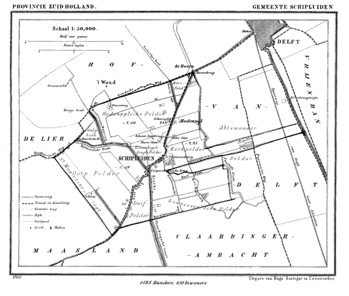
File:Schipluiden.gif
From Wikimedia Commons, the free media repository
Jump to navigation
Jump to search

Size of this preview: 705 × 599 pixels. Other resolutions: 282 × 240 pixels | 565 × 480 pixels | 904 × 768 pixels | 1,205 × 1,024 pixels | 1,600 × 1,360 pixels.
Original file (1,600 × 1,360 pixels, file size: 176 KB, MIME type: image/gif)
File information
Structured data
Captions
Captions
Add a one-line explanation of what this file represents
Summary
[edit]| DescriptionSchipluiden.gif |
Nederlands: Schipluiden: kaart uit atlas van circa 1866.
|
| Date | |
| Source |
Gemeente Atlas van Nederland, J. Kuyper 1865-1870, Uitgave Hugo Suringar Leeuwarden. (via www.kuijsten.de/atlas/) |
| Author |
J. Kuyper Scan by Rob Kuijsten |
| Permission (Reusing this file) |
PD-Old |
Licensing
[edit]| Public domainPublic domainfalsefalse |
|
This work is in the public domain in its country of origin and other countries and areas where the copyright term is the author's life plus 70 years or fewer. Note that a few countries have copyright terms longer than 70 years: Mexico has 100 years, Jamaica has 95 years, Colombia has 80 years, and Guatemala and Samoa have 75 years. This image may not be in the public domain in these countries, which moreover do not implement the rule of the shorter term. Honduras has a general copyright term of 75 years, but it does implement the rule of the shorter term. Copyright may extend on works created by French who died for France in World War II (more information), Russians who served in the Eastern Front of World War II (known as the Great Patriotic War in Russia) and posthumously rehabilitated victims of Soviet repressions (more information).
| |
| This file has been identified as being free of known restrictions under copyright law, including all related and neighboring rights. | |
https://creativecommons.org/publicdomain/mark/1.0/PDMCreative Commons Public Domain Mark 1.0falsefalse
Original upload log
[edit]The original description page was here. All following user names refer to nl.wikipedia.
- 2005-03-31 08:22 Michiel1972 1600×1360×4 (180692 bytes) Schipluiden: kaart uit atlas van 1866 Vrij te gebruiken, maar alleen op de wikipedia. Wel graag met bronvermelding [http://www.rat.de/kuijsten/atlas/gr/] of [http://www.rat.de/kuijsten/atlas/] {{beperkt}}
File history
Click on a date/time to view the file as it appeared at that time.
| Date/Time | Thumbnail | Dimensions | User | Comment | |
|---|---|---|---|---|---|
| current | 22:53, 14 March 2008 |  | 1,600 × 1,360 (176 KB) | File Upload Bot (Magnus Manske) (talk | contribs) | {{BotMoveToCommons|nl.wikipedia}} {{Information |Description={{nl|Schipluiden: kaart uit atlas van 1866}} |Source=Transferred from [http://nl.wikipedia.org nl.wikipedia] |Date=2005-03-31 (original upload date) |Author=Original uploader was [[:nl:User:Mic |
You cannot overwrite this file.
File usage on Commons
There are no pages that use this file.
File usage on other wikis
The following other wikis use this file:
- Usage on nl.wikipedia.org