File:Schierke Barenberg lub 2024-05-11 img02 FDGB Erholungsheim Hermann Duncker.jpg
Jump to navigation
Jump to search

Size of this preview: 800 × 600 pixels. Other resolutions: 320 × 240 pixels | 640 × 480 pixels | 1,024 × 768 pixels | 1,280 × 960 pixels | 2,560 × 1,920 pixels | 4,032 × 3,024 pixels.
Original file (4,032 × 3,024 pixels, file size: 7.52 MB, MIME type: image/jpeg)
Captions
Captions
Add a one-line explanation of what this file represents
Summary
[edit]
| Description |
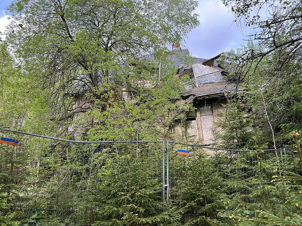
Deutsch: Ehemaliges FDGB Erholungsheim Hermann Duncker in Schierke, Wernigerode, Landkreis Harz, Sachsen-Anhalt, Deutschland. Das Gebäude wurde 1909 erbaut, diente während des ersten Weltkrieges als Lazarett, danach als Kurhotel. 1924 wurde das Gebäude zum "Erholungsheim Barenberg" ausgebaut. Nach 1945 geht es in die Hände des Freien Deutschen Gewerkschaftsbundes (FDGB). In den 1960er-Jahren erhielt das Gebäude seinen heutigen Namen. Benannt ist das Gebäude nach Hermann Duncker, Gründungsmitglied der KPD. Das Gebäude soll zwar erhalten und wieder aufgebaut werden, der aktuelle Zustand ist jedoch sehr schlecht. Das Gebäude ist bereits in Teilen eingestürzt.
English: Former FDGB Hermann Duncker recovery home in Schierke, Wernigerode, Harz district, Saxony-Anhalt, Germany. The building was built in 1909, served as a military hospital during the First World War and then as a spa hotel. In 1924 the building was expanded into the “Barenberg recreation home”. After 1945 it passed into the hands of the Free German Trade Union Confederation (FDGB). The building received its current name in the 1960s. The building is named after Hermann Duncker, a founding member of the KPD. The building is intended to be preserved and rebuilt, but its current condition is very poor. Parts of the building have already collapsed. |
| Date | |
| Source | Own work |
| Author | Lukas Beck |
| Camera location | | View this and other nearby images on: OpenStreetMap |
|---|
Licensing
[edit]
I, the copyright holder of this work, hereby publish it under the following license:
This file is licensed under the Creative Commons Attribution 4.0 International license.
- You are free:
- to share – to copy, distribute and transmit the work
- to remix – to adapt the work
- Under the following conditions:
- attribution – You must give appropriate credit, provide a link to the license, and indicate if changes were made. You may do so in any reasonable manner, but not in any way that suggests the licensor endorses you or your use.
File history
Click on a date/time to view the file as it appeared at that time.
| Date/Time | Thumbnail | Dimensions | User | Comment | |
|---|---|---|---|---|---|
| current | 16:40, 17 June 2024 | | 4,032 × 3,024 (7.52 MB) | L. Beck (talk | contribs) | Uploaded own work with UploadWizard |
You cannot overwrite this file.
File usage on Commons
The following 2 pages use this file: