File:Schönheide unterer Ortsteil vom Ostabhang des Berges Knock aus Ansichtskarte um 1900.jpg
Jump to navigation
Jump to search

Size of this preview: 800 × 520 pixels. Other resolutions: 320 × 208 pixels | 640 × 416 pixels | 1,024 × 665 pixels | 1,280 × 832 pixels | 2,560 × 1,663 pixels | 3,245 × 2,108 pixels.
Original file (3,245 × 2,108 pixels, file size: 1.92 MB, MIME type: image/jpeg)
Captions
Captions
Add a one-line explanation of what this file represents
Summary
[edit]
| Description |
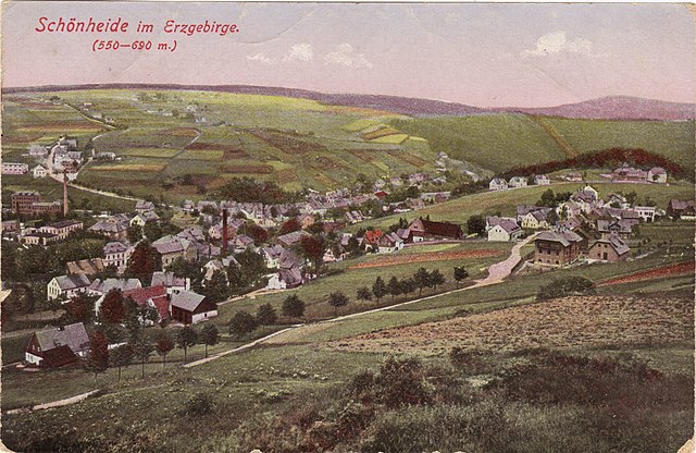
Deutsch: Blick vom Ostabhang des Berges Knock auf den unteren Teil von Schönheide im Erzgebirge: im Vordergrund rechts das ehemalige Krankenhaus und die Häuser des Ortsteils Schädlichsberg, dahinter rechts vor dem Wald die frühere Hammerschule (1908 gebaut), links davon die Häuserreihe, Guchheh genannt, davor die grüne Fläche: Gebiet des früheren Uttmannschen Vorwerks, links im Tal des Dorfbaches, der in den Filzbach fließt, das Schönheider Unterdorf, weiter unten die Häuserreihe der Ziegenleithe. Links oben der Ortsteil Webersberg mit seiner verstreuten Bebauung, in diesem Ortsteil auf halber Höhe am linken Bildrand die Kunzmannsche Fabrik, gegenüber Emil Kunzmanns Villa. |
| Date | about before 1900 |
| Source | Scan of a postcard |
| Author | Unknown author |
| Permission (Reusing this file) |
This image is in the public domain due to its age. |
| Camera location | | View this and other nearby images on: OpenStreetMap |
|---|
Licensing
[edit]
|
This work is in the public domain in its country of origin and other countries and areas where the copyright term is the author's life plus 70 years or fewer. This work is in the public domain in the United States because it was published (or registered with the U.S. Copyright Office) before January 1, 1929. | |
| This file has been identified as being free of known restrictions under copyright law, including all related and neighboring rights. | |
| Annotations | This image is annotated: View the annotations at Commons |
File history
Click on a date/time to view the file as it appeared at that time.
| Date/Time | Thumbnail | Dimensions | User | Comment | |
|---|---|---|---|---|---|
| current | 10:27, 17 August 2018 | | 3,245 × 2,108 (1.92 MB) | Klaaschwotzer (talk | contribs) | {{Information |description ={{de|1=Blick vom Ostabhang des Berges Knock auf den unteren Teil von Schönheide im Erzgebirge: im Vordergrund rechts das ehemalige Krankenhaus und die Häuser des Ortsteils Schädlichsberg, dahinter rechts vor dem Wald die frühere Hammerschule (1908 gebaut), links davon die Häuserreihe, Guchheh genannt, davor die grüne Fläche: Gebiet des früheren [[:de:Uttmanns Vorwerk|Utt... |
You cannot overwrite this file.
File usage on Commons
The following page uses this file:
File usage on other wikis
The following other wikis use this file:
- Usage on de.wikipedia.org
- Usage on www.wikidata.org