File:Schönfelder Hochland bei Gönnsdorf (Foto Norbert Kaiser) .jpg
Jump to navigation
Jump to search
Size of this preview: 800 × 111 pixels. Other resolutions: 320 × 44 pixels | 640 × 89 pixels | 1,024 × 142 pixels | 7,220 × 1,000 pixels.
Original file (7,220 × 1,000 pixels, file size: 5.29 MB, MIME type: image/jpeg)
Captions
Captions
Add a one-line explanation of what this file represents
Summary
[edit]_.jpg&action=edit§ion=1)
| Description |
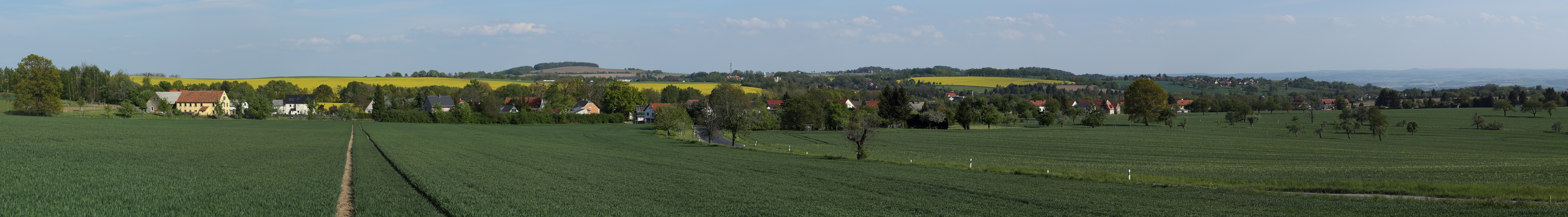
Deutsch: Blick vom östlichen Ortsrand von Gönnsdorf über das Schönfelder Hochland. Im Vordergrund liegt Cunnersdorf. Dahinter sind halblinks der Triebenberg (383 Meter) und halbrechts der Borsberg (361 Meter) zu sehen. Dazwischen liegt Schönfeld. Nach rechts (Süden) fällt das Schönfelder Hochland zum Elbtal ab. Hier erkennt man am Horizont die Höhen des Osterzgebirges mit dem Sattelberg/ Špičák u Krásného Lesa (723 Meter). |
| Date | |
| Source | Own work |
| Author | Norbert Kaiser |
| Permission (Reusing this file) |
Deutsch: Dieses Foto wurde von Norbert Kaiser erstellt und unter nachfolgend aufgeführter Lizenz veröffentlicht. Das Bild kann frei verwendet werden solange der Urheber (Norbert Kaiser), die Quelle (Wikimedia Commons) und die Lizenz (CC-BY-SA 4.0) in erkennbarem Zusammenhang mit dem Bild genannt wird.
English: This photo was taken by Norbert Kaiser and released under the license(s) stated below. You are free to use it for any purpose as long as you credit the author (Norbert Kaiser), the Source (Wikimedia Commons) and the license (CC-BY-SA 4.0) in close relation to the image.
I, the copyright holder of this work, hereby publish it under the following license: This file is licensed under the Creative Commons Attribution-Share Alike 4.0 International license.
|
| Annotations | This image is annotated: View the annotations at Commons |
_.jpg)
File history
Click on a date/time to view the file as it appeared at that time.
| Date/Time | Thumbnail | Dimensions | User | Comment | |
|---|---|---|---|---|---|
| current | 22:55, 28 November 2020 | 7,220 × 1,000 (5.29 MB) | Norbert Kaiser (talk | contribs) | == {{int:filedesc}} == {{Information |description= {{de|Blick vom östlichen Ortsrand von Gönnsdorf über das Schönfelder Hochland. Im Vordergrund liegt Cunnersdorf. Dahinter sind halblinks der Triebenberg (383 Meter) und halbrechts der Borsberg (361 Meter) zu sehen. Dazwischen liegt Schönfeld. Nach rechts (Süden) fällt das Schönfelder Hochland zum Elbtal ab. Hier erkennt man am Horizont die Höhen des Osterzgebirges mit dem Sattelberg/ Špičák u Krásného Lesa (723 Meter).}} |date=2020-05-08 |so... |
You cannot overwrite this file.
File usage on Commons
The following 3 pages use this file:
File usage on other wikis
The following other wikis use this file:
- Usage on de.wikipedia.org
_.jpg&oldid=900827360)