File:Schéma du donjon du château de Landrecies.svg
Jump to navigation
Jump to search

Size of this PNG preview of this SVG file: 90 × 125 pixels. Other resolutions: 173 × 240 pixels | 345 × 480 pixels | 553 × 768 pixels | 737 × 1,024 pixels | 1,474 × 2,048 pixels.
Original file (SVG file, nominally 90 × 125 pixels, file size: 27 KB)
Captions
Captions
Add a one-line explanation of what this file represents
Summary
[edit]
| Description |
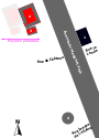
Français : Schéma des vestiges du donjon du château de Landrecies lors des fouilles de 1896.
1. Maison visible sur les photos lors des fouilles, située au 8 Avenue du Maréchal Foch ; 2. donjon ; 3. bâtiment en partie adossé à celui-ci. ; 4. Tour sud-est du château, par la suite convertie en poudrière et toujours existante au coin de l'avenue du Maréchal Foch et de la rue Jeanne de Lallaing. Les dimensions du donjon et du bâtiment adossé sont reprises de cet article relatant les résultats des fouilles : "Une découvert archéologique à Landrecies", Le Monde illustré, p.232. L'orientation et la position du donjon et du bâtiment annexe ont pu être déterminées approximativement grâce à cette photographie prise lors des fouilles (voir l'article où elle a été publiée), où l'on aperçoit à l'arrière-plan l'avenue du Maréchal Foch et sur la droite la maison au n°8 de cette avenue. On aperçoit également derrière cette maison la toiture de la maison au coin des rues la Lande et Paul Deloffre. La photo ne permet pas de déterminer la distance (est-ouest) entre le donjon et la maison au n°8 de l'avenue, on sait seulement que l'ensemble donjon/bâtiment adossé est légèrement au nord de la maison et semble parallèle à l'avenue du Maréchal Foch. |
| Date | |
| Source | Own work |
| Creator | |
| Geotemporal data | |
| Date depicted | |
| Map location | Landrecies |
| Georeferencing | If inappropriate please set warp_status = skip to hide. |
Licensing
[edit]
I, the copyright holder of this work, hereby publish it under the following license:
This file is licensed under the Creative Commons Attribution-Share Alike 4.0 International license.
- You are free:
- to share – to copy, distribute and transmit the work
- to remix – to adapt the work
- Under the following conditions:
- attribution – You must give appropriate credit, provide a link to the license, and indicate if changes were made. You may do so in any reasonable manner, but not in any way that suggests the licensor endorses you or your use.
- share alike – If you remix, transform, or build upon the material, you must distribute your contributions under the same or compatible license as the original.
File history
Click on a date/time to view the file as it appeared at that time.
| Date/Time | Thumbnail | Dimensions | User | Comment | |
|---|---|---|---|---|---|
| current | 08:46, 2 February 2022 | | 90 × 125 (27 KB) | Arflhn (talk | contribs) | MAJ |
| 08:44, 2 February 2022 |  | 90 × 125 (27 KB) | Arflhn (talk | contribs) | maj | |
| 18:13, 1 February 2022 |  | 80 × 125 (17 KB) | Arflhn (talk | contribs) | maj | |
| 18:11, 1 February 2022 |  | 80 × 125 (15 KB) | Arflhn (talk | contribs) | MAJ | |
| 17:39, 1 February 2022 |  | 75 × 112 (12 KB) | Arflhn (talk | contribs) | MAJ | |
| 17:26, 1 February 2022 |  | 75 × 112 (11 KB) | Arflhn (talk | contribs) | Uploaded own work with UploadWizard |
You cannot overwrite this file.
File usage on Commons
The following page uses this file:
File usage on other wikis
The following other wikis use this file:
- Usage on fr.wikipedia.org