File:Scala dei Turchi 2017.jpg
![File:Scala dei Turchi 2017.jpg](https://upload.wikimedia.org/wikipedia/commons/thumb/5/5b/Scala_dei_Turchi_2017.jpg/800px-Scala_dei_Turchi_2017.jpg?20240214131622)
Original file (4,867 × 3,234 pixels, file size: 5.42 MB, MIME type: image/jpeg)
Captions
Captions
![]() |
![]() This media file has been nominated for deletion since 25 May 2024. To discuss it, please visit the nomination page.
Do not remove this tag until the deletion nomination is closed. Reason for the nomination: Files have promotional descriptions and aren't in use. Due to the large amount of potential G10 tags, opening a DR instead for the second group of 1442 odd files (the rest of the user's uploads).
| ||
Show further instructions
If this template was added because you clicked "Mark for deletion" in the left menu (right when using Vector 2022 skin), please make sure that all necessary pages have been created. If they haven't been created after a few minutes, or if you added this template manually, you should complete these steps:
{{subst:delete2|image=Files uploaded by Prolete|reason=Files have promotional descriptions and aren't in use. Due to the large amount of potential G10 tags, opening a DR instead for the second group of 1442 odd files (the rest of the user's uploads).}} ~~~~
For mass deletions: If you want to nominate several related images, please make a mass request by manually adding Note: This template is for requests that may require discussion in order to be deleted. For speedy deletions, you can use
|
Summary
[edit]DescriptionScala dei Turchi 2017.jpg |
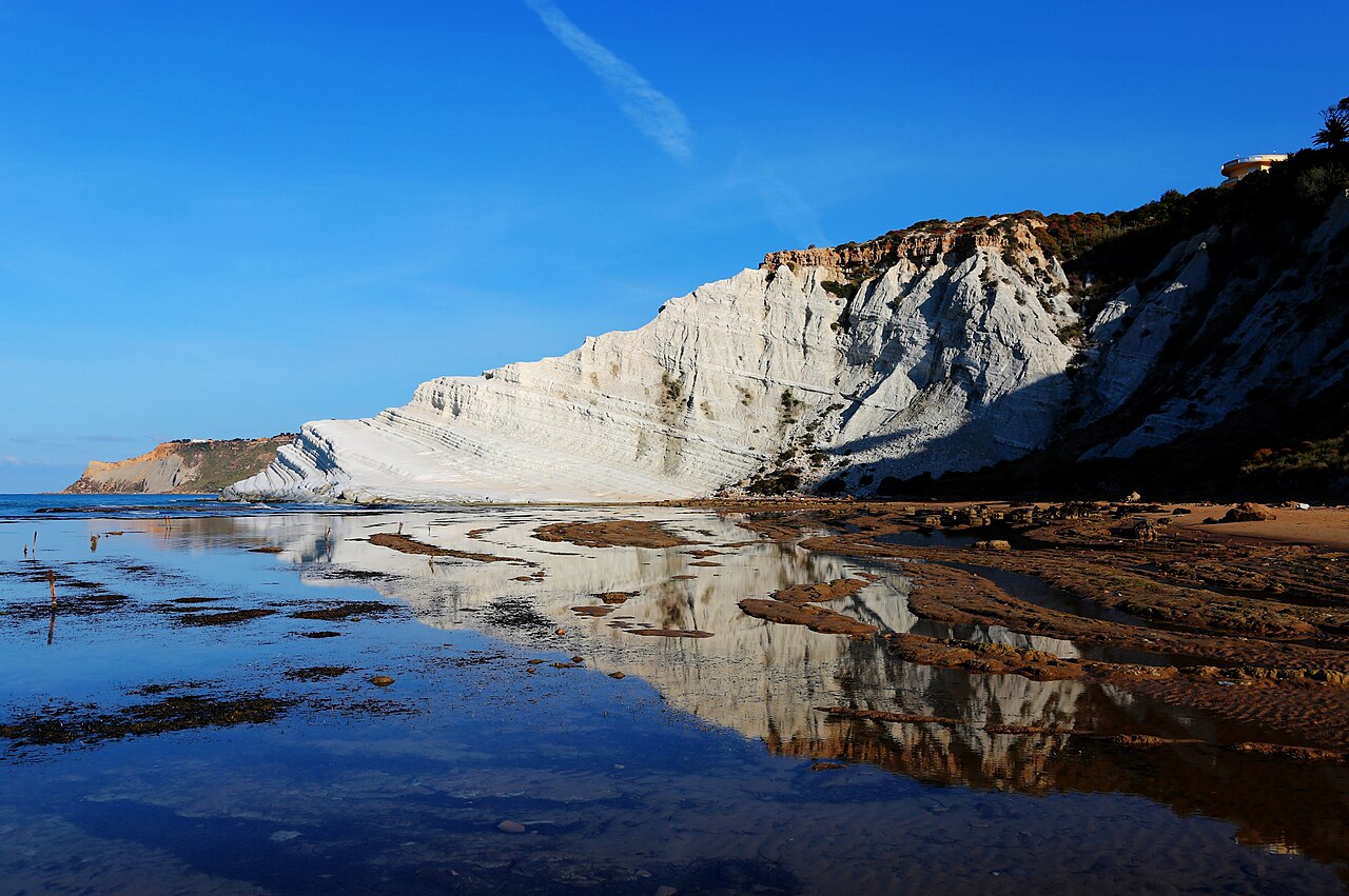
Italiano: La Scala dei Turchi è una parete rocciosa (falesia) che si erge a picco sul mare lungo la costa tra Realmonte e Porto Empedocle, in provincia di Agrigento.
La Scala è costituita di marna, una roccia sedimentaria di natura calcarea e argillosa, con un caratteristico colore bianco puro. Tale scogliera dal singolare aspetto si erge in mezzo tra due spiagge di sabbia fine, e per accedervi bisogna procedere lungo il litorale e inerpicarsi in una salita somigliante a una grande scalinata naturale di pietra calcarea. Una volta raggiunta la sommità della scogliera, il paesaggio visibile abbraccia la costa agrigentina fino a Capo Rossello. La Scala dei Turchi presenta una forma ondulata e irregolare, con linee non aspre bensì dolci e rotondeggianti. Il nome le viene dalle passate incursioni di pirateria da parte dei saraceni, genti arabe e, per convenzione, turche; i pirati turchi, infatti, trovavano riparo in questa zona meno battuta dai venti e rappresentante un più sicuro approdo. [wikipedia]English: Scala dei Turchi, April 2017 |
Date | |
Source | https://www.flickr.com/photos/strocchi/34472345933/ |
Author | Enrico Strocchi |
Camera location | 37° 17′ 19.98″ N, 13° 28′ 29.21″ E ![]() | View this and other nearby images on: OpenStreetMap | ![]() |
---|
Licensing
[edit]![w:en:Creative Commons](https://upload.wikimedia.org/wikipedia/commons/thumb/7/79/CC_some_rights_reserved.svg/90px-CC_some_rights_reserved.svg.png)
![attribution](https://upload.wikimedia.org/wikipedia/commons/thumb/1/11/Cc-by_new_white.svg/24px-Cc-by_new_white.svg.png)
![share alike](https://upload.wikimedia.org/wikipedia/commons/thumb/d/df/Cc-sa_white.svg/24px-Cc-sa_white.svg.png)
- You are free:
- to share – to copy, distribute and transmit the work
- to remix – to adapt the work
- Under the following conditions:
- attribution – You must give appropriate credit, provide a link to the license, and indicate if changes were made. You may do so in any reasonable manner, but not in any way that suggests the licensor endorses you or your use.
- share alike – If you remix, transform, or build upon the material, you must distribute your contributions under the same or compatible license as the original.
![]() |
This image was originally posted to Flickr by Strocchi at https://flickr.com/photos/46383895@N00/34472345933. It was reviewed on 14 February 2024 by FlickreviewR 2 and was confirmed to be licensed under the terms of the cc-by-sa-2.0. |
14 February 2024
File history
Click on a date/time to view the file as it appeared at that time.
Date/Time | Thumbnail | Dimensions | User | Comment | |
---|---|---|---|---|---|
current | 13:16, 14 February 2024 | ![]() | 4,867 × 3,234 (5.42 MB) | Prolete (talk | contribs) | Uploaded a work by Enrico Strocchi from https://www.flickr.com/photos/strocchi/34472345933/ with UploadWizard |
You cannot overwrite this file.
File usage on Commons
There are no pages that use this file.
Metadata
This file contains additional information such as Exif metadata which may have been added by the digital camera, scanner, or software program used to create or digitize it. If the file has been modified from its original state, some details such as the timestamp may not fully reflect those of the original file. The timestamp is only as accurate as the clock in the camera, and it may be completely wrong.
Camera manufacturer | Canon |
---|---|
Camera model | Canon EOS 6D |
Author | Enrico Strocchi |
Copyright holder | |
Exposure time | 1/1,250 sec (0.0008) |
F-number | f/6.3 |
ISO speed rating | 100 |
Date and time of data generation | 07:08, 24 April 2017 |
Lens focal length | 28 mm |
Latitude | 37° 17′ 19.97″ N |
Longitude | 13° 28′ 29.21″ E |
Altitude | 37.2 meters below sea level |
Orientation | Normal |
Horizontal resolution | 72 dpi |
Vertical resolution | 72 dpi |
Software used | GIMP 2.8.18 |
File change date and time | 13:45, 13 June 2017 |
Exposure Program | Manual |
Exif version | 2.3 |
Date and time of digitizing | 07:08, 24 April 2017 |
APEX shutter speed | 10.375039394894 |
APEX aperture | 5.3561438561439 |
APEX exposure bias | 0 |
Metering mode | Pattern |
Flash | Flash did not fire, compulsory flash suppression |
DateTime subseconds | 00 |
DateTimeOriginal subseconds | 00 |
DateTimeDigitized subseconds | 00 |
Supported Flashpix version | 1 |
Color space | sRGB |
Focal plane X resolution | 3,810.5849582173 |
Focal plane Y resolution | 3,815.89958159 |
Focal plane resolution unit | inches |
Custom image processing | Normal process |
Exposure mode | Manual exposure |
White balance | Auto white balance |
Scene capture type | Standard |
GPS time (atomic clock) | 06:08 |
Satellites used for measurement | 11 |
Receiver status | Measurement in progress |
Measurement mode | 3-dimensional measurement |
Measurement precision | Fair (8.5) |
Geodetic survey data used | WGS-84 |
GPS date | 24 April 2017 |
GPS tag version | 0.0.3.2 |