File:Satellite images of the Toni-Hongo village in May 2010 and in April 2011.jpg
Jump to navigation
Jump to search

No higher resolution available.
Satellite_images_of_the_Toni-Hongo_village_in_May_2010_and_in_April_2011.jpg (746 × 273 pixels, file size: 42 KB, MIME type: image/jpeg)
Captions
Captions
Add a one-line explanation of what this file represents
Summary
[edit]
| Description |
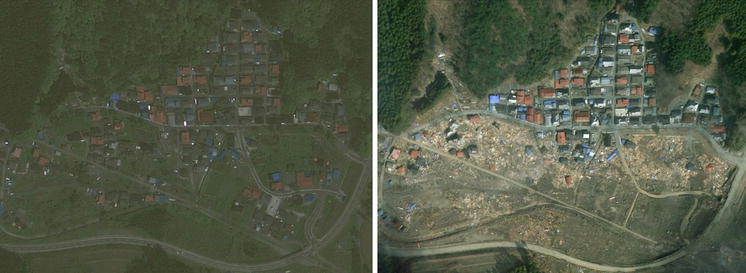
English: Source: Anawat Suppasri, Nobuo Shuto, Fumihiko Imamura, Shunichi Koshimura, Erick Mas, Ahmet Cevdet Yalciner: "Lessons Learned from the 2011 Great East Japan Tsunami: Performance of Tsunami Countermeasures, Coastal Buildings, and Tsunami Evacuation in Japan", Pure and Applied Geophysics, 170, 6-8, (2013), pp. 993–1018, DOI:10.1007/s00024-012-0511-7, online published on 7 July 2012, here: p. 1014, Figure 30 ("Satellite images of the Toni-Hongo village in May 2010 and in April 2011"), Licence: Creative Commons Attribution 2.0 Generic (CC BY 2.0). URL of the image file: https://media.springernature.com/original/springer-static/image/art%3A10.1007%2Fs00024-012-0511-7/MediaObjects/24_2012_511_Fig30_HTML.jpg.
Caption as given in the above cited source: "FDigure 30 - Satellite images of the Toni-Hongo village in May 2010 and in April 2011" Context as given in the above cited source: "The Toni-Hongo village was struck by the 1896 tsunami (with a tsunami height of 14.5 m and 224 houses destroyed) and the 1933 tsunami (with a tsunami height of 9.3 m and 101 houses destroyed) (Meiji University, 2011). After the 1933 tsunami, the village was rebuilt on high land at an elevation of 20 m (MSL), as shown in Fig. 29, left. The village survived the 1960 Chilean tsunami, which was ~5 m high. After this event, many houses were built in the lowland areas to accommodate the increasing population, as shown in a picture from 2009 (Fig. 29, center) and a satellite image from 2010 (Fig. 30, left). The 2011 tsunami destroyed the lowland houses but not the highland houses (Figs. 29, right, 30, right)." |
| Date | |
| Source | Anawat Suppasri, Nobuo Shuto, Fumihiko Imamura, Shunichi Koshimura, Erick Mas, Ahmet Cevdet Yalciner: "Lessons Learned from the 2011 Great East Japan Tsunami: Performance of Tsunami Countermeasures, Coastal Buildings, and Tsunami Evacuation in Japan", Pure and Applied Geophysics, 170, 6-8, (2013), pp. 993–1018, DOI:10.1007/s00024-012-0511-7, online published on 7 July 2012, here: p. 1014, Figure 30 ("Satellite images of the Toni-Hongo village in May 2010 and in April 2011"), Licence: Creative Commons Attribution 2.0 Generic (CC BY 2.0). URL of the image file: https://media.springernature.com/original/springer-static/image/art%3A10.1007%2Fs00024-012-0511-7/MediaObjects/24_2012_511_Fig30_HTML.jpg. |
| Author | Anawat Suppasri, Nobuo Shuto, Fumihiko Imamura, Shunichi Koshimura, Erick Mas, Ahmet Cevdet Yalciner: "Lessons Learned from the 2011 Great East Japan Tsunami: Performance of Tsunami Countermeasures, Coastal Buildings, and Tsunami Evacuation in Japan", Pure and Applied Geophysics, 170, 6-8, (2013), pp. 993–1018, DOI:10.1007/s00024-012-0511-7, online published on 7 July 2012, here: p. 1014, Figure 30 ("Satellite images of the Toni-Hongo village in May 2010 and in April 2011"), Licence: Creative Commons Attribution 2.0 Generic (CC BY 2.0). URL of the image file: https://media.springernature.com/original/springer-static/image/art%3A10.1007%2Fs00024-012-0511-7/MediaObjects/24_2012_511_Fig30_HTML.jpg. |
| Permission (Reusing this file) |
This file is licensed under the Creative Commons Attribution 2.0 Generic license. Attribution: Anawat Suppasri, Nobuo Shuto, Fumihiko Imamura, Shunichi Koshimura, Erick Mas, Ahmet Cevdet Yalciner
|
File history
Click on a date/time to view the file as it appeared at that time.
| Date/Time | Thumbnail | Dimensions | User | Comment | |
|---|---|---|---|---|---|
| current | 16:53, 17 August 2018 | 746 × 273 (42 KB) | Anglo-Araneophilus~commonswiki (talk | contribs) | {{Information |description ={{en|1=Source: Anawat Suppasri, Nobuo Shuto, Fumihiko Imamura, Shunichi Koshimura, Erick Mas, Ahmet Cevdet Yalciner: "Lessons Learned from the 2011 Great East Japan Tsunami: Performance of Tsunami Countermeasures, Coastal Buildings, and Tsunami Evacuation in Japan", Pure and Applied Geophysics, 170, 6-8, (2013), pp. 993–1018, DOI:10.1007/s00024-012-0511-7, online published on 7 July 2012, here: p. 1014, Figure 30 ("Satellite images of the Toni-Hongo village in Ma... |
You cannot overwrite this file.
File usage on Commons
There are no pages that use this file.
File usage on other wikis
The following other wikis use this file:
- Usage on de.wikipedia.org