File:Saska Kępa.png

Original file (1,781 × 1,783 pixels, file size: 3.46 MB, MIME type: image/png)
Captions
Captions
Summary
[edit]
| Description |
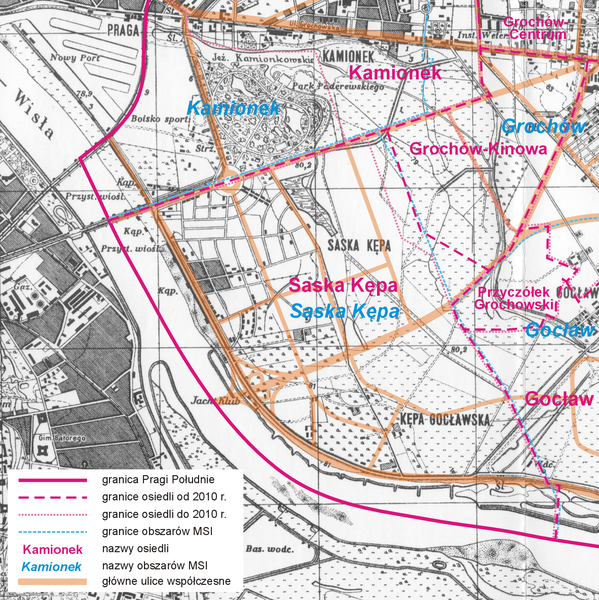
Polski: Mapa Saskiej Kępy w Warszawie. Mapa topograficzna Wojskowego Instytutu Geograficznego 1:25 000 ark.: Pas 40-Słup 32-B Warszawa-Mokotów, z 1931 r. z naniesionym przebiegiem współczesnych ważniejszych ulic oraz granicami osiedli uchwalonymi przez Radę Dzielnicy Praga Południe i granicami obszarów wg Miejskiego Systemu Informacji |
||||
| Date | Before World War II/2010-06-02 | ||||
| Source | Wojskowy Instytut Geograficzny + Own work | ||||
| Author | Wojskowy Instytut Geograficzny (topographic map)/Aotearoa | ||||
| Permission (Reusing this file) |
topographic map:
modern content: I, the copyright holder of this work, hereby publish it under the following license: This file is licensed under the Creative Commons Attribution 3.0 Unported license.
|
||||
File history
Click on a date/time to view the file as it appeared at that time.
| Date/Time | Thumbnail | Dimensions | User | Comment | |
|---|---|---|---|---|---|
| current | 14:48, 2 June 2010 | | 1,781 × 1,783 (3.46 MB) | Aotearoa (talk | contribs) | poprawa pliku |
| 14:38, 2 June 2010 |  | 1,782 × 1,786 (1.51 MB) | Aotearoa (talk | contribs) | {{Information |Description={{pl|1=Mapa Saskiej Kepy w Warszawie}} |Source={{own}} |Author=Aotearoa |Date=2010-06-02 |Permission= |other_versions= }} Category:Saska Kępa |
You cannot overwrite this file.
File usage on Commons
There are no pages that use this file.
File usage on other wikis
The following other wikis use this file:
- Usage on pl.wikipedia.org