File:Sasca Montana, tabulo, 1a.jpeg
From Wikimedia Commons, the free media repository
Jump to navigation
Jump to search
Size of this preview: 600 × 600 pixels. Other resolutions: 240 × 240 pixels | 480 × 480 pixels | 768 × 768 pixels | 1,024 × 1,024 pixels | 1,360 × 1,360 pixels.
Original file (1,360 × 1,360 pixels, file size: 474 KB, MIME type: image/jpeg)
File information
Structured data
Captions
DescriptionSasca Montana, tabulo, 1a.jpeg |
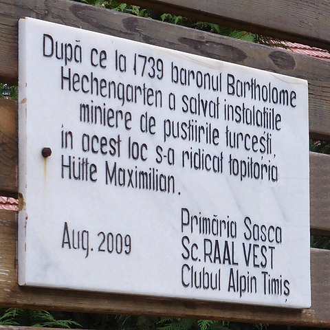
Deutsch: Sasca Montană (RO), Erinnerungstafel an die Schmelzhütte Maximilian.
Esperanto: Sasca Montană (RO), plako memoriga pri la erc-fandejo Hütte Maximilian.
Română: Sasca Montană (CS), placă despre topitoria Hütte Maximilian. |
|||
Date | ||||
Source | Self-photographed | |||
Author | Renardo la vulpo | |||
Permission (Reusing this file) |
I, the copyright holder of this work, hereby publish it under the following license:
|
This is a retouched picture, which means that it has been digitally altered from its original version. Modifications: Verdeckte Teile ergänzt / kompletigis kovritajn partojn.
|
File history
Click on a date/time to view the file as it appeared at that time.
Date/Time | Thumbnail | Dimensions | User | Comment | |
---|---|---|---|---|---|
current | 20:46, 31 January 2018 | 1,360 × 1,360 (474 KB) | Renardo la vulpo (talk | contribs) | {{Information |Description={{de|1=Sasca Montană (RO), Erinnerungstafel an die Schmelzhütte Maximilian.}} {{eo|1=Sasca Montană (RO), plako memoriga pri la erc-fandejo ''Hütte Maximilian''.}} {{ro|1=Sasca Montană (CS), plac... |
You cannot overwrite this file.
File usage on Commons
There are no pages that use this file.
Metadata
This file contains additional information such as Exif metadata which may have been added by the digital camera, scanner, or software program used to create or digitize it. If the file has been modified from its original state, some details such as the timestamp may not fully reflect those of the original file. The timestamp is only as accurate as the clock in the camera, and it may be completely wrong.
Camera manufacturer | Panasonic |
---|---|
Camera model | DMC-TZ41 |
Exposure time | 1/50 sec (0.02) |
F-number | f/5.3 |
ISO speed rating | 400 |
Date and time of data generation | 15:52, 28 March 2015 |
Lens focal length | 18.2 mm |
Latitude | 17,056,881° 51′ 12.15″ N |
Longitude | 17,056,881° 51′ 12.15″ E |
Altitude | 0 meters above sea level |
Orientation | Normal |
Horizontal resolution | 180 dpi |
Vertical resolution | 180 dpi |
Software used | GIMP 2.8.20 |
File change date and time | 21:32, 31 January 2018 |
Y and C positioning | Co-sited |
Exposure Program | Normal program |
Exif version | 2.3 |
Date and time of digitizing | 15:52, 28 March 2015 |
Meaning of each component |
|
Image compression mode | 2 |
APEX exposure bias | 0 |
Maximum land aperture | 4.8046875 APEX (f/5.29) |
Metering mode | Center weighted average |
Light source | Unknown |
Flash | Flash did not fire, compulsory flash suppression |
Supported Flashpix version | 1 |
Color space | sRGB |
Sensing method | One-chip color area sensor |
File source | Digital still camera |
Scene type | A directly photographed image |
Custom image processing | Normal process |
Exposure mode | Auto exposure |
White balance | Auto white balance |
Digital zoom ratio | 0 |
Focal length in 35 mm film | 102 mm |
Scene capture type | Standard |
Scene control | High gain up |
Contrast | Normal |
Saturation | Normal |
Sharpness | Normal |
GPS time (atomic clock) | 00:00 |
Receiver status | Measurement interoperability |
Measurement mode | 2-dimensional measurement |
Measurement precision | Excellent (0) |
Reference for direction of image | Magnetic direction |
Direction of image | 135 |
Geodetic survey data used | WGS-84 |
GPS date | 0000:00:00 |
GPS tag version | 0.0.3.2 |
Image width | 1,360 px |
Image height | 1,360 px |
Name of GPS processing method | 14 bytes undefined data |
Name of GPS area | 266 bytes undefined data |