File:Santorini Island.jpg

Original file (3,508 × 2,540 pixels, file size: 2.42 MB, MIME type: image/jpeg)
Captions
Captions
Summary
[edit]
| Description |
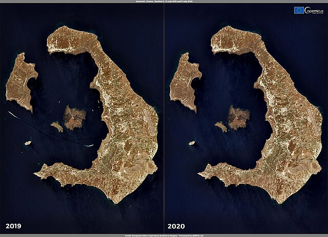
English: Restrictions on travel, introduced in response to the COVID-19 pandemic, are slowly being eased, allowing tourism to restart in a growing number of destinations. The latest research by the World Tourism Organization (UNWTO) shows that many destinations worldwide have reopened, with Europe leading the way. In Santorini, the most visited island of Greece, hoteliers expect occupancy to reach only 15% of the levels from recent years. Few if none of the cruise ships that normally moor in the bay of Santorini are expected this year. This visualisation compares images acquired by the Copernicus Sentinel-2 satellites on 12 July 2019 and 11 July 2020 over the bay of Santorini. The complete absence of ships is evident in the image on the right (2020). Data acquired by the Copernicus Sentinel-2 satellites are useful for monitoring and surveillance applications including ship traffic, water quality monitoring and fisheries production mapping. |
| Date | 16 July 2020 (upload date) |
| Source | Santorini Island |
| Author | European Union , Copernicus Sentinel-2 imagery |
Licensing
[edit]

|
This image contains data from a satellite in the Copernicus Programme, such as Sentinel-1, Sentinel-2 or Sentinel-3. Attribution is required when using this image.
Attribution: Contains modified Copernicus Sentinel data 2020
The use of Copernicus Sentinel Data is regulated under EU law (Commission Delegated Regulation (EU) No 1159/2013 and Regulation (EU) No 377/2014). Relevant excerpts:
Free access shall be given to GMES dedicated data [...] made available through GMES dissemination platforms [...].
Access to GMES dedicated data [...] shall be given for the purpose of the following use in so far as it is lawful:
GMES dedicated data [...] may be used worldwide without limitations in time.
GMES dedicated data and GMES service information are provided to users without any express or implied warranty, including as regards quality and suitability for any purpose. |
File history
Click on a date/time to view the file as it appeared at that time.
| Date/Time | Thumbnail | Dimensions | User | Comment | |
|---|---|---|---|---|---|
| current | 21:04, 27 July 2023 | | 3,508 × 2,540 (2.42 MB) | OptimusPrimeBot (talk | contribs) | #Spacemedia - Upload of https://www.copernicus.eu/system/files/2020-07/image_day/Santorini_credit_row.jpg via Commons:Spacemedia |
You cannot overwrite this file.
File usage on Commons
There are no pages that use this file.