File:Santali map.png
Jump to navigation
Jump to search

Size of this preview: 516 × 599 pixels. Other resolutions: 207 × 240 pixels | 413 × 480 pixels | 661 × 768 pixels | 882 × 1,024 pixels | 1,510 × 1,753 pixels.
Original file (1,510 × 1,753 pixels, file size: 303 KB, MIME type: image/png)
Captions
Captions
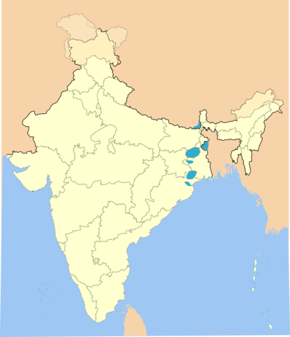
Santal-speaking regions
Summary
[edit]
| Description |
English: Regions where Santal is spoken commonly |
| Date | |
| Source | Derivative of India-locator-map-blank.svg |
| Author | Own work based off of Nichalp |
Licensing
[edit]
This file is licensed under the Creative Commons Attribution-Share Alike 3.0 Unported license.
- You are free:
- to share – to copy, distribute and transmit the work
- to remix – to adapt the work
- Under the following conditions:
- attribution – You must give appropriate credit, provide a link to the license, and indicate if changes were made. You may do so in any reasonable manner, but not in any way that suggests the licensor endorses you or your use.
- share alike – If you remix, transform, or build upon the material, you must distribute your contributions under the same or compatible license as the original.
File history
Click on a date/time to view the file as it appeared at that time.
| Date/Time | Thumbnail | Dimensions | User | Comment | |
|---|---|---|---|---|---|
| current | 03:09, 14 July 2022 | | 1,510 × 1,753 (303 KB) | Dev0745 (talk | contribs) | Reverted to version as of 17:14, 5 March 2020 (UTC) as per census 2011 |
| 19:33, 25 June 2020 |  | 428 × 406 (61 KB) | C1MM (talk | contribs) | Reverted to version as of 19:27, 25 June 2020 (UTC) | |
| 19:29, 25 June 2020 |  | 428 × 406 (61 KB) | C1MM (talk | contribs) | Reverted to version as of 19:24, 25 June 2020 (UTC) | |
| 19:27, 25 June 2020 |  | 428 × 406 (61 KB) | C1MM (talk | contribs) | Fixed boundaries | |
| 19:24, 25 June 2020 |  | 428 × 406 (61 KB) | C1MM (talk | contribs) | Fixed boundaries | |
| 19:14, 25 June 2020 |  | 428 × 405 (60 KB) | C1MM (talk | contribs) | Reduced area | |
| 17:14, 5 March 2020 |  | 1,510 × 1,753 (303 KB) | C1MM (talk | contribs) | Uploaded a work by Own work based off of Nichalp from Derivative of India-locator-map-blank.svg with UploadWizard |
You cannot overwrite this file.
File usage on Commons
The following 3 pages use this file:
File usage on other wikis
The following other wikis use this file:
- Usage on ast.wikipedia.org
- Usage on be.wikipedia.org
- Usage on ca.wikipedia.org
- Usage on diq.wikipedia.org
- Usage on eo.wikipedia.org
- Usage on id.wikipedia.org
- Usage on lv.wikipedia.org
- Usage on oc.wikipedia.org
- Usage on ru.wikipedia.org
- Usage on sat.wikipedia.org
- Usage on vi.wikipedia.org
- Usage on www.wikidata.org