File:Sanderumgaard kort 1808 Peder Larsen Birk.png
Jump to navigation
Jump to search

Size of this preview: 641 × 599 pixels. Other resolutions: 257 × 240 pixels | 513 × 480 pixels | 821 × 768 pixels | 1,095 × 1,024 pixels | 2,190 × 2,048 pixels | 2,584 × 2,416 pixels.
Original file (2,584 × 2,416 pixels, file size: 8.58 MB, MIME type: image/png)
Captions
Captions
Add a one-line explanation of what this file represents
Summary
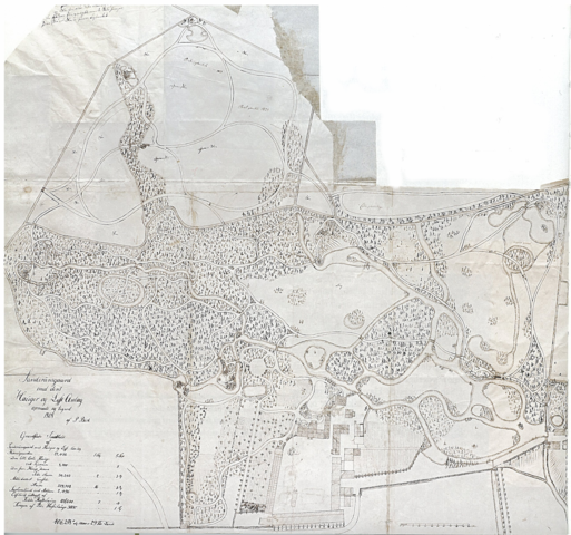
[edit]| Sanderumgaard med dens Hauger og Lyst Anlæg opmaalt og tegnet 1808
( |
||||||||||||||||||||||||
|---|---|---|---|---|---|---|---|---|---|---|---|---|---|---|---|---|---|---|---|---|---|---|---|---|
| Artist |
Dansk: Peder Larsen Birk (årstal ukendt) var landinspektør English: Peder Larsen Birk was a surveyor working for Johan Bülow at the romantic garden at Sanderumgaard, Odense, Denmark |
|||||||||||||||||||||||
| Title |
Sanderumgaard med dens Hauger og Lyst Anlæg opmaalt og tegnet 1808 |
|||||||||||||||||||||||
| Description |
Dansk: Sanderumgaard med dens Hauger og Lyst Anlæg opmaalt og tegnet 1808 - Landinspektør Peder Larsen Birk tegnede 1808 dette kort for Johan Bülow over det romantiske haveanlæg som Bülow havde arbejdet på siden 1793 ved Sanderumgaard, Odense, Danmark - Haven var netop blevet udvidet med et stort areal mod syd, som er det bare område opad på kortet. Hovedbygning og andre bygninger ses nederst på kortet. Man ser de slyngede kanaler og stier. Rundt om i haven var placeret forskellige haveelementer, og Bülow fik nogle af tidens kunstnere til at udføre prospekter af dem og haven i øvrigt, bl.a. maleren C.W. Eckersberg og kobberstikkeren J.F. Clemens (se Category:Sanderumgård) |
|||||||||||||||||||||||
| Date | 1808 | |||||||||||||||||||||||
| Dimensions | 69.0 x 76.0 cm | |||||||||||||||||||||||
| Collection |
|
|||||||||||||||||||||||
| Current location |
English: The Antiquarian and Topographical Archive, Copenhagen |
|||||||||||||||||||||||
| Notes | An exhibition was held 25-05-2010 - 26-09-2010 at Funen's Art Museum in relation to the reopening of the romantic garden at Sanderumgaard, Odense, Denmark after a restoration. This map figures in the exhibition book page 56. | |||||||||||||||||||||||
| References |
|
|||||||||||||||||||||||
| Source/Photographer | Scanned from the exhibtion book page 56 - Anne Christiansen: Sanderumgaards Romantiske Have, 2010 - About the exhibition book | |||||||||||||||||||||||
| Permission (Reusing this file) |
An expired work | |||||||||||||||||||||||
| Other versions |
 (Here north is up) |
|||||||||||||||||||||||

Licensing
[edit]
|
This work is in the public domain in its country of origin and other countries and areas where the copyright term is the author's life plus 100 years or fewer. | |
| This file has been identified as being free of known restrictions under copyright law, including all related and neighboring rights. | |
File history
Click on a date/time to view the file as it appeared at that time.
| Date/Time | Thumbnail | Dimensions | User | Comment | |
|---|---|---|---|---|---|
| current | 10:41, 7 May 2013 | | 2,584 × 2,416 (8.58 MB) | PHansen (talk | contribs) | A larger map |
| 08:21, 16 March 2013 |  | 739 × 612 (829 KB) | PHansen (talk | contribs) | {{Artwork |artist={{da|Peder Larsen Birk (årstal ukendt) var landinspektør}} {{en|Peder Larsen Birk was a surveyor working for Johan Bülow at the romantic garden at [[:da:Sanderumgård|Sa... |
You cannot overwrite this file.
File usage on Commons
The following 4 pages use this file:
File usage on other wikis
The following other wikis use this file:
- Usage on da.wikipedia.org