File:Sanborn Seattle 1905 - map 209.jpg
Jump to navigation
Jump to search

Size of this preview: 438 × 599 pixels. Other resolutions: 175 × 240 pixels | 351 × 480 pixels | 561 × 768 pixels | 1,243 × 1,700 pixels.
Original file (1,243 × 1,700 pixels, file size: 213 KB, MIME type: image/jpeg)
Captions
Captions
Add a one-line explanation of what this file represents
Summary
[edit]
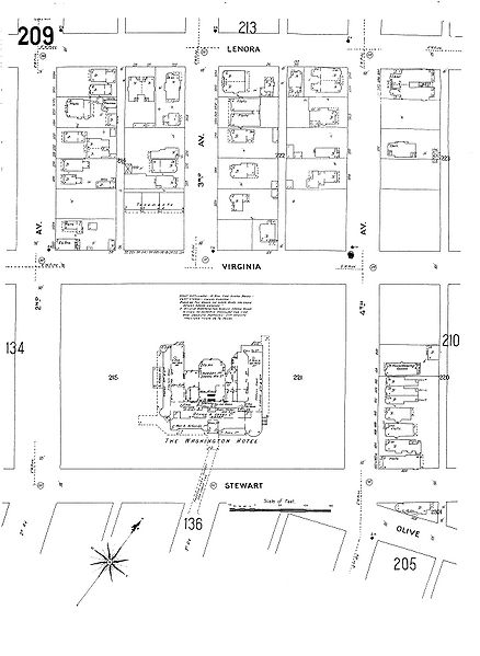
| Description | 1905 map of part of Seattle, Washington. The map extends from Second Avenue northeast to Fourth Avenue and roughly from Stewart Street northwest to Lenora Street. At the time this was still Denny Hill - this is just before the regrade - and the two blocks here along Stewart were occupied by the Washington Hotel (originally Denny Hotel) and its grounds. |
| Date | |
| Source | Map 209, Insurance Maps of Seattle, Volume Two, Sanborn Map Company, 11 Broadway, New York, reproduced on the "Digital Sanborn Maps 1867-1970" online (subscription) database |
| Author | Pacific Dept Sanborn Map Company (San Francisco) |
| Permission (Reusing this file) |
PD-US |
| Other versions | Image:Sanborn Seattle 1905 - map 209 - Washington Hotel.jpg is a detail view of just the hotel and the comments pertaining to it. |
Licensing
[edit]
This media file is in the public domain in the United States. This applies to U.S. works where the copyright has expired, often because its first publication occurred prior to January 1, 1929, and if not then due to lack of notice or renewal. See this page for further explanation.
|
 | |
 |
This image might not be in the public domain outside of the United States; this especially applies in the countries and areas that do not apply the rule of the shorter term for US works, such as Canada, Mainland China (not Hong Kong or Macao), Germany, Mexico, and Switzerland. The creator and year of publication are essential information and must be provided. See Wikipedia:Public domain and Wikipedia:Copyrights for more details.
|
File history
Click on a date/time to view the file as it appeared at that time.
| Date/Time | Thumbnail | Dimensions | User | Comment | |
|---|---|---|---|---|---|
| current | 15:53, 7 October 2008 | | 1,243 × 1,700 (213 KB) | Jmabel (talk | contribs) | == Summary == {{Information |Description=1905 map of part of Seattle, Washington. The map extends from Second Avenue northeast to Fourth Avenue and roughly from Stewart Street northwest to Lenora Street. At the time this was still Denny Hill - this is jus |
You cannot overwrite this file.
File usage on Commons
There are no pages that use this file.
File usage on other wikis
The following other wikis use this file:
- Usage on en.wikipedia.org