File:Sanborn Fire Insurance Map from Hudson Co., Hudson County, New Jersey. LOC sanborn05511 010-1-clip-021-097.jpg
Jump to navigation
Jump to search

Size of this preview: 800 × 412 pixels. Other resolutions: 320 × 165 pixels | 640 × 330 pixels | 1,094 × 564 pixels.
Original file (1,094 × 564 pixels, file size: 191 KB, MIME type: image/jpeg)
Captions
Captions
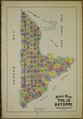
Index (middle section) for Volume 10, 1898 Sanborn Fire Insurance Map from Hudson Co., Hudson County, New Jersey
Summary
[edit]| Description |
English: Vol. 10, 1898. 129 Sheet(s). Includes Bayonne. Bound. Sheets 021 to 097 |
||
| Title | Sanborn Fire Insurance Map from Hudson Co., Hudson County, New Jersey. | ||
| Shelf ID | https://www.loc.gov/item/sanborn05511_010/ | ||
| Parent | https://www.loc.gov/resource/g3814hm.g3814hm_g05511189810/ | ||
| Sheet title | Image 1 of Sanborn Fire Insurance Map from Hudson Co., Hudson County, New Jersey. | ||
| Location | New Jersey · Hudson County · Bayonne | ||
| Part of | American Memory · Sanborn Maps · Geography And Maps Division · Sanborn Fire Insurance Maps | ||
| Date | |||
| Source |
|
||
| Creator |
Unknown |
||
| Permission (Reusing this file) |
|
||
| Georeferencing | If inappropriate please set warp_status = skip to hide. | ||
| Other versions |
|


Licensing
[edit]
This work is in the public domain in the United States because it was published (or registered with the U.S. Copyright Office) before January 1, 1929.
Public domain works must be out of copyright in both the United States and in the source country of the work in order to be hosted on the Commons. If the work is not a U.S. work, the file must have an additional copyright tag indicating the copyright status in the source country.
Note: This tag should not be used for sound recordings. |
File history
Click on a date/time to view the file as it appeared at that time.
| Date/Time | Thumbnail | Dimensions | User | Comment | |
|---|---|---|---|---|---|
| current | 11:23, 19 November 2022 | | 1,094 × 564 (191 KB) | DutchTreat (talk | contribs) | Uploaded a work by Unknown from {{LOC-map|id=g3814hm.g3814hm_g05511189810}} with UploadWizard |
You cannot overwrite this file.
File usage on Commons
The following page uses this file: