File:San Quintín Glacier in Chile.jpg
Original file (3,900 × 2,540 pixels, file size: 4.28 MB, MIME type: image/jpeg)
Captions
Captions
Summary
[edit]
| Description |
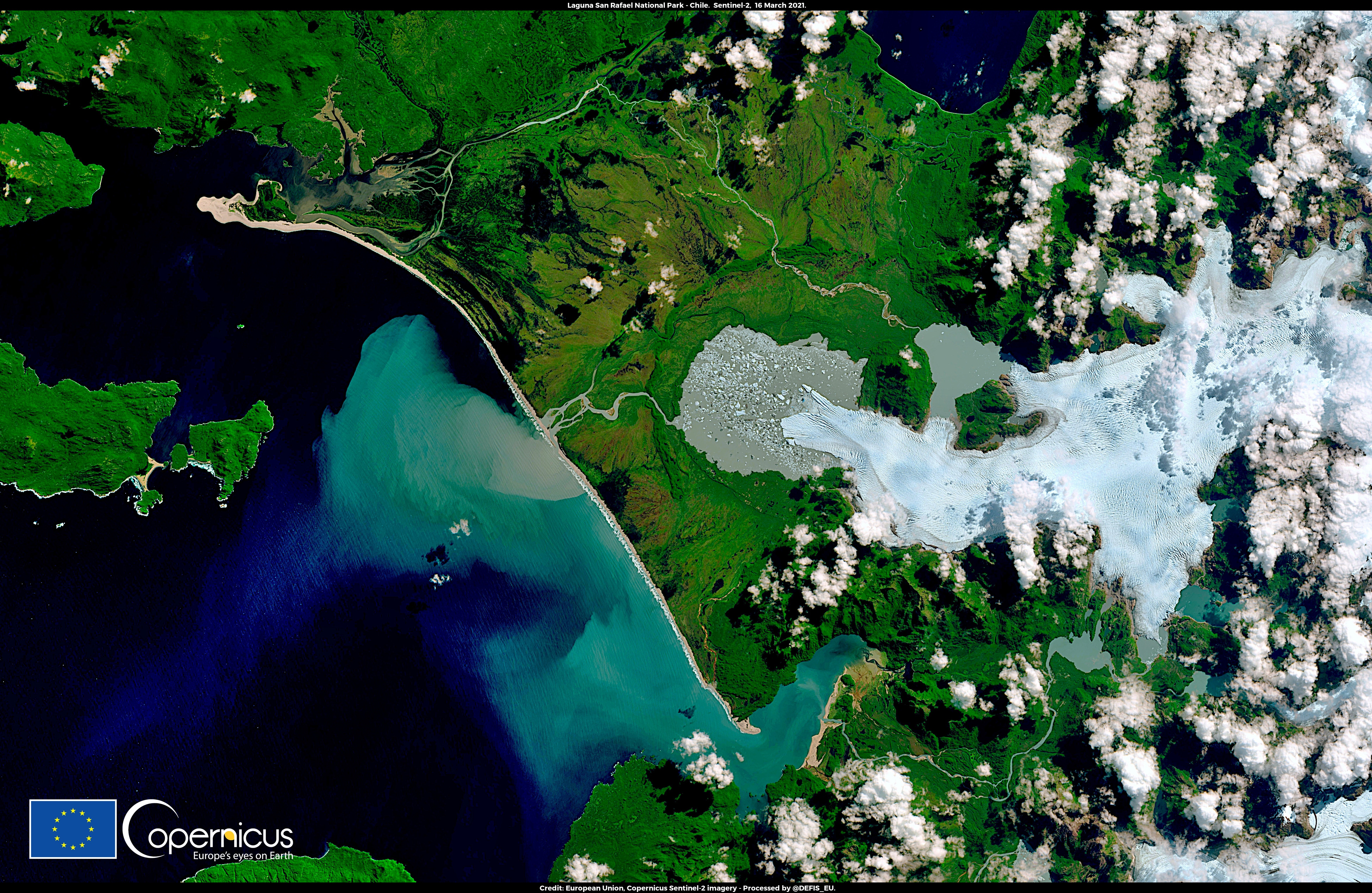
English: This image, acquired by one of the Copernicus Sentinel-2 satellites on 16 March 2021, shows the terminal part of the San Quintín Glacier in Chile, which has been in rapid retreat for the past 30 years due to the effects of climate change. The San Quintín Glacier is located in the Laguna San Rafael National Park, which hosts the second largest contiguous ice sheet outside polar regions. Until 1991 it advanced over the surrounding vegetation-covered land, but it has since begun to retreat and melt, forming a proglacial lake at its terminus. According to Mauri Pelto, Professor of Environmental Science at Nichols College in Massachusetts, the San Quintín Glacier Lake may be the fastest growing lake of the 21st century in South America. Meltwater from retreating glaciers such as the San Quintín Glacier contributes to rising sea levels. In 2020, the Copernicus Sentinel-6 Michael Freilich satellite was launched into orbit with the mission of accurately measuring the height of the sea surface until at least 2030. The open data it delivers will improve our knowledge and understanding of the sea level rise as a consequence of climate change. |
| Date | Taken on 16 March 2021 |
| Source | San Quintín Glacier in Chile |
| Author | European Union, Copernicus Sentinel-2 imagery |
Licensing
[edit]

|
This image contains data from a satellite in the Copernicus Programme, such as Sentinel-1, Sentinel-2 or Sentinel-3. Attribution is required when using this image.
Attribution: Contains modified Copernicus Sentinel data 2021
The use of Copernicus Sentinel Data is regulated under EU law (Commission Delegated Regulation (EU) No 1159/2013 and Regulation (EU) No 377/2014). Relevant excerpts:
Free access shall be given to GMES dedicated data [...] made available through GMES dissemination platforms [...].
Access to GMES dedicated data [...] shall be given for the purpose of the following use in so far as it is lawful:
GMES dedicated data [...] may be used worldwide without limitations in time.
GMES dedicated data and GMES service information are provided to users without any express or implied warranty, including as regards quality and suitability for any purpose. |
File history
Click on a date/time to view the file as it appeared at that time.
| Date/Time | Thumbnail | Dimensions | User | Comment | |
|---|---|---|---|---|---|
| current | 08:32, 27 August 2023 | | 3,900 × 2,540 (4.28 MB) | OptimusPrimeBot (talk | contribs) | #Spacemedia - Upload of https://www.copernicus.eu/system/files/2021-03/image_day/20210319_LagunaSanRafael_ClimateChange.jpg via Commons:Spacemedia |
You cannot overwrite this file.
File usage on Commons
There are no pages that use this file.