File:San Nicholas Island California military facilities.png
Jump to navigation
Jump to search
No higher resolution available.
San_Nicholas_Island_California_military_facilities.png (734 × 385 pixels, file size: 353 KB, MIME type: image/png)
Captions
Captions
Add a one-line explanation of what this file represents
Summary
[edit]
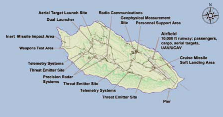
| Description | Map showing the military facilities on San Nicolas Island, California (USA). |
| Date | |
| Source | U.S. Navy NAVAIR San Nicolas Island factsheet (NAVAIR Public Release 09-153) [1] |
| Author | USN |
Licensing
[edit]
This file is a work of a sailor or employee of the U.S. Navy, taken or made as part of that person's official duties. As a work of the U.S. federal government, it is in the public domain in the United States.
|
 | |
| This file has been identified as being free of known restrictions under copyright law, including all related and neighboring rights. | ||
File history
Click on a date/time to view the file as it appeared at that time.
| Date/Time | Thumbnail | Dimensions | User | Comment | |
|---|---|---|---|---|---|
| current | 15:53, 21 August 2010 | | 734 × 385 (353 KB) | Cobatfor (talk | contribs) | == {{int:filedesc}} == {{Information |Description=Map showing the military facilities on San Nicolas Island, California (USA). |Source=U.S. Navy NAVAIR San Nicolas Island factsheet (NAVAIR Public Release 09-153) [http://www.navair.navy.mil/ranges/SEA/docs |
You cannot overwrite this file.
File usage on Commons
There are no pages that use this file.
File usage on other wikis
The following other wikis use this file:
- Usage on de.wikipedia.org
- Usage on en.wikipedia.org
- Usage on eo.wikipedia.org
- Usage on ja.wikipedia.org
- Usage on nl.wikipedia.org
- Usage on zh.wikipedia.org