File:San-pedro-en-cuchabrachi.png
Jump to navigation
Jump to search
No higher resolution available.
San-pedro-en-cuchabrachi.png (280 × 320 pixels, file size: 29 KB, MIME type: image/png)
Captions
Captions
Add a one-line explanation of what this file represents
Summary
[edit]
| Description |
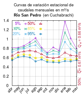
Español: Curva de Variación Estacional del río San Pedro (del Salar de Atacama) en Cuchabrachi.
#{{cita publicación
# | apellido       = Dirección General de Aguas
# | nombre         =
# | enlace-autor   = Ministerio de Obras Públicas (Chile)
# | título         = Diagnóstico y clasificación de los cursos y cuerpos de agua según objetivos de calidad. Cuenca Río San Pedro
# | ubicación      = Santiago de Chile
# | editorial      = [[Ministerio de Obras Públicas (Chile)]]
# | año            = 2004
# | edición        =
# | url            = https://mma.gob.cl/wp-content/uploads/2017/12/Atacama.pdf
# | urlarchivo     =
# | fechaarchivo   =
# | ref            = harv
#  }} Tabla 4.1 (m3/s) pág. 27
mes 5% 10% 20% 50% 85% 95%
abr 0.822 0.773 0.723 0.646 0.578 0.547
may 0.822 0.799 0.771 0.718 0.653 0.615
jun 0.856 0.828 0.795 0.735 0.668 0.632
jul 0.938 0.893 0.842 0.753 0.655 0.604
ago 1.025 0.952 0.870 0.733 0.593 0.524
sep 0.822 0.788 0.749 0.680 0.604 0.563
oct 0.711 0.689 0.662 0.611 0.548 0.511
nov 0.828 0.757 0.687 0.594 0.527 0.502
dic 0.752 0.718 0.680 0.612 0.538 0.498
ene 1.380 1.147 0.943 0.708 0.571 0.531
feb 1.019 0.900 0.789 0.649 0.555 0.523
mar 0.793 0.750 0.705 0.637 0.577 0.550
|
| Date | |
| Source | Own work |
| Author | Juan Villalobos |
| Permission (Reusing this file) |
I, the copyright holder of this work, hereby publish it under the following license: This file is licensed under the Creative Commons Attribution-Share Alike 4.0 International license.
|
| Object location | | View this and other nearby images on: OpenStreetMap |
|---|
File history
Click on a date/time to view the file as it appeared at that time.
| Date/Time | Thumbnail | Dimensions | User | Comment | |
|---|---|---|---|---|---|
| current | 10:34, 2 October 2019 | | 280 × 320 (29 KB) | Juan Villalobos (talk | contribs) | media y mediana |
| 08:04, 22 April 2019 |  | 280 × 320 (25 KB) | Juan Villalobos (talk | contribs) | User created page with UploadWizard |
You cannot overwrite this file.
File usage on Commons
There are no pages that use this file.
File usage on other wikis
The following other wikis use this file:
- Usage on es.wikipedia.org