File:Salzwanderweg 11.jpg
Jump to navigation
Jump to search

Size of this preview: 524 × 599 pixels. Other resolutions: 210 × 240 pixels | 420 × 480 pixels | 891 × 1,019 pixels.
Original file (891 × 1,019 pixels, file size: 424 KB, MIME type: image/jpeg)
Captions
Captions
Add a one-line explanation of what this file represents
Summary
[edit]
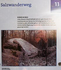
| Description | Standort 11 des Salzwanderwegs in Bad Friedrichshall: NES-Bunker 152. |
| Date | |
| Source | Own work |
| Author | Sarang |
| Object location | | View this and other nearby images on: OpenStreetMap |
|---|
Licensing
[edit]
| I, the copyright holder of this work, release this work into the public domain. This applies worldwide. In some countries this may not be legally possible; if so: I grant anyone the right to use this work for any purpose, without any conditions, unless such conditions are required by law. |
File history
Click on a date/time to view the file as it appeared at that time.
| Date/Time | Thumbnail | Dimensions | User | Comment | |
|---|---|---|---|---|---|
| current | 15:25, 21 March 2021 | | 891 × 1,019 (424 KB) | Sarang (talk | contribs) | {{Information |Description=Standort 11 des Salzwanderwegs in Bad Friedrichshall: {{C|Neckar-Enz-Stellung|NES}}-Bunker 152. |Date=2015-11-03 |Source={{own}} |Author={{U|Sarang}} }} <!-- {{Object location||dim:512}} --> == {{int:license-header}} == {{PD-self}} 11 |
You cannot overwrite this file.
File usage on Commons
The following 6 pages use this file: