File:Saline Island at Saline Landing.jpg
Jump to navigation
Jump to search

Size of this preview: 800 × 450 pixels. Other resolutions: 320 × 180 pixels | 640 × 360 pixels | 1,024 × 576 pixels | 1,280 × 720 pixels | 2,816 × 1,584 pixels.
Original file (2,816 × 1,584 pixels, file size: 1.47 MB, MIME type: image/jpeg)
Captions
Captions
Add a one-line explanation of what this file represents
|
This is an image of a place or building that is listed on the National Register of Historic Places in the United States of America. Its reference number is 98001291. |
| Camera location | | View this and other nearby images on: OpenStreetMap |
|---|
| Description |
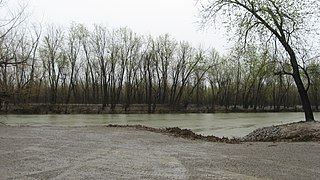
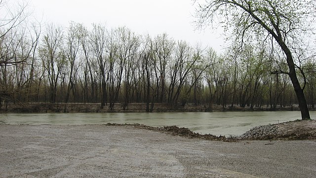
English: Land near the southern point of Saline Island, the peninsula at the confluence of the Saline River with the Ohio River. Picture is taken from the landing on the other side of the Saline River in Saline Landing, Illinois, United States; Saline Island itself is in Union County, Kentucky, even though it is attached to the Illinois side of the Ohio River and thus not an island. Location of a Civil War skirmish, the "island" is listed on the National Register of Historic Places. |
||
| Date | Taken on 11 April 2013 | ||
| Source | Own work | ||
| Author | Nyttend | ||
| Permission (Reusing this file) |
|
File history
Click on a date/time to view the file as it appeared at that time.
| Date/Time | Thumbnail | Dimensions | User | Comment | |
|---|---|---|---|---|---|
| current | 02:49, 24 April 2013 | | 2,816 × 1,584 (1.47 MB) | Nyttend (talk | contribs) | {{NRHP|98001291}} {{Location|37|34|17|N|88|7|45|W}} {{Information |Description={{en|Land near the southern point of {{w|Saline Island}}, the peninsula at the confluence of the {{w|Saline River (Illinois)|Saline River}} with the {{w|Ohio River}}. Pictu... |
You cannot overwrite this file.
File usage on Commons
There are no pages that use this file.
File usage on other wikis
The following other wikis use this file:
- Usage on de.wikipedia.org
- Usage on en.wikipedia.org
- Usage on www.wikidata.org