File:Salgir valley panorama.jpg
Jump to navigation
Jump to search

Size of this preview: 799 × 150 pixels. Other resolutions: 320 × 60 pixels | 640 × 120 pixels | 1,024 × 192 pixels | 1,280 × 240 pixels | 5,937 × 1,115 pixels.
Original file (5,937 × 1,115 pixels, file size: 2.19 MB, MIME type: image/jpeg)
Captions
Captions
Add a one-line explanation of what this file represents
Summary
[edit]
| Description |
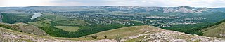
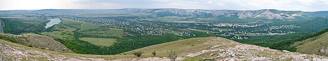
Русский: Панорамное фото Салгирской и Ангарской долин с северо-восточных склонов Чатырдага (Крым). В правой части панорамы видны сёла Перевальное и Чайковское; в левой части панорамы видно Аянское водохранилище и село Заречное. Слева вдали видно село Доброе и Симферопольское водохранилище. Вдали справа и по центру видны склоны Долгоруковской яйлы. Esperanto: Panorama vidaĵo al la Salgira kaj Angara valoj de sur la nordorientaj deklivoj de Ĉatirdago (Krimeo). Dekstre videblas la vilaĝoj Perevalno kaj Ĉajkovsko; maldekstre videblas la Ajana akvorezervujo kaj la vilaĝo Zareĉno. Maldekstre en foro videblas la vilaĝo Dobro kaj la Simferopola akvorezervujo. Malproksime en la centro kaj dekstre videblas la deklivoj de la Dolgorukova altebenaĵo English: Panorama of the Salhir and Angara valley's made from the northeast slopes of Chatyr-Dag mountain (Crimea). On the right one can see the villages Perevalne and Chaykovske; on the left one can see the Ayan reservoir and the village Zarichne. Far on the left one can see the village Dobre and the Simferopol reservoir. Far in the right and central parts one can see the slopes of the Dolgorukovskaya Yayla. |
| Date | |
| Source | Own work |
| Author | Mevo (Павел Можаев) |
Licensing
[edit]
I, the copyright holder of this work, hereby publish it under the following license:
This file is licensed under the Creative Commons Attribution-Share Alike 3.0 Unported license.
- You are free:
- to share – to copy, distribute and transmit the work
- to remix – to adapt the work
- Under the following conditions:
- attribution – You must give appropriate credit, provide a link to the license, and indicate if changes were made. You may do so in any reasonable manner, but not in any way that suggests the licensor endorses you or your use.
- share alike – If you remix, transform, or build upon the material, you must distribute your contributions under the same or compatible license as the original.
File history
Click on a date/time to view the file as it appeared at that time.
| Date/Time | Thumbnail | Dimensions | User | Comment | |
|---|---|---|---|---|---|
| current | 21:14, 6 October 2013 | 5,937 × 1,115 (2.19 MB) | Mevo (talk | contribs) | User created page with UploadWizard |
You cannot overwrite this file.
File usage on Commons
There are no pages that use this file.
File usage on other wikis
The following other wikis use this file:
- Usage on kk.wikipedia.org
- Usage on myv.wikipedia.org
- Usage on ru.wikipedia.org
- Usage on ru.wikivoyage.org