File:Salar de Uyuni - Bolívia.jpg

Original file (4,226 × 3,200 pixels, file size: 4.49 MB, MIME type: image/jpeg)
Captions
Captions
Summary
[edit]| Description |
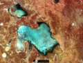
English: Satélite / Satellite: CBERS-4
Sensor: AWFI Data / Date: 20-02-2018 / 02-20-2018 Bandas / Bands: R16-G15-B14 Onde / Where: Salar-de-Uyuni é o maior deserto de sal do mundo, com cerca de 10.500 km2, localizado na borda da Cordilheira dos Andes, Bolívia. É uma importante reserva de Lítio, metal de pouco peso e utilizado na construção de baterias. Veja as áreas de mineração (região inferior azul da imagem). O Salar é inundado de janeiro a março. / Salar-de-Uyuni is the largest salt desert in the world, with about 10.500 km2, located on the border of the Andes, Bolivia. It is an important stock of Lithium, light metal and used in battery building. See the mining areas (lower region blue of the image). The Salar is flooded from January to March. Cena / Scene: CBERS-4 174/123 |
| Date | |
| Source | https://www.flickr.com/photos/153282474@N02/39735000370/ |
| Author | Coordenação-Geral de Observação da Terra/INPE |
| Other versions |
|
Licensing
[edit]
- You are free:
- to share – to copy, distribute and transmit the work
- to remix – to adapt the work
- Under the following conditions:
- attribution – You must give appropriate credit, provide a link to the license, and indicate if changes were made. You may do so in any reasonable manner, but not in any way that suggests the licensor endorses you or your use.
- share alike – If you remix, transform, or build upon the material, you must distribute your contributions under the same or compatible license as the original.
| This image was originally posted to Flickr by Coordenação-Geral de Observação da Terra/INPE at https://flickr.com/photos/153282474@N02/39735000370. It was reviewed on 9 April 2020 by FlickreviewR 2 and was confirmed to be licensed under the terms of the cc-by-sa-2.0. |
File history
Click on a date/time to view the file as it appeared at that time.
| Date/Time | Thumbnail | Dimensions | User | Comment | |
|---|---|---|---|---|---|
| current | 10:15, 9 April 2020 | | 4,226 × 3,200 (4.49 MB) | Jo-Jo Eumerus (talk | contribs) | Uploaded a work by Coordenação-Geral de Observação da Terra/INPE from https://www.flickr.com/photos/153282474@N02/39735000370/ with UploadWizard |
You cannot overwrite this file.
File usage on Commons
The following page uses this file: