File:Saint Cyr Aérodrome.jpg
Jump to navigation
Jump to search
Size of this preview: 800 × 511 pixels. Other resolutions: 320 × 204 pixels | 640 × 409 pixels | 1,091 × 697 pixels.
Original file (1,091 × 697 pixels, file size: 464 KB, MIME type: image/jpeg)
Captions
Captions
Add a one-line explanation of what this file represents
Summary
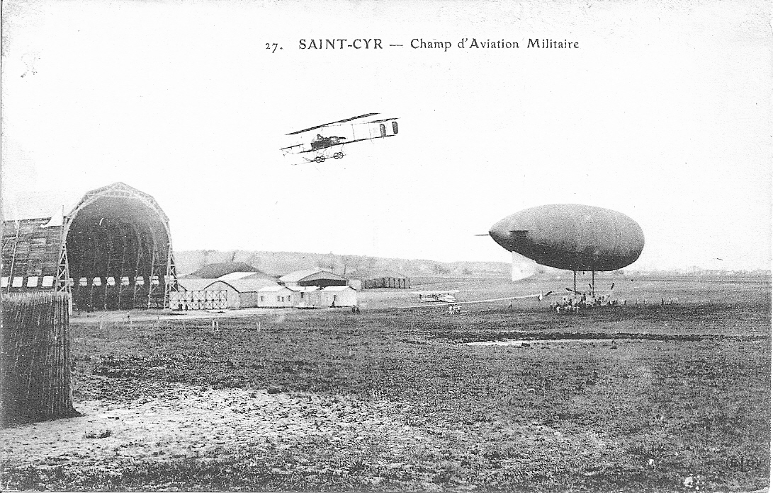
[edit]| Description | 27. SAINT-CYR -- Champ d'Aviation Militaire, carte postale ancienne |
| Date | Début du XX siècle |
| Source | Own work |
| Author | Langladure |
| Permission (Reusing this file) |
Collection personnelle, je suis propriétaire de la Carte postale |
| Other versions |
|
| Notes | Vue postérieure à 1907 et antérieure à septembre 1910 du terrain en bordure de la route aux cochons (actuelle rue du Docteur Vaillant) à Saint-Cyr utilisé comme base d'aérostation et piste d'aviation. Aéronef amarrée et hangar survolés par un biplan. Le hangar à dirigeable construit en 1907 à l'initiative de Henry de La Vaulx était destiné à abriter un dirigeable dit aéronat et à perfectionner des engins de locomotion aérienne. Champ d'aviation militaire à partir de 1912, utilisé pour l'aéromodélisme pendant l'Occupation, rendu à l'aviation civile en 1944 et géré à partir de 1945 par "L'Aéroport de Paris", aujourd'hui Aéroports de Paris sous l'appellation de Aérodrome de Saint-Cyr-l'École (Cf.Site des aéroports franciliens pour leurs voisins). |

Licensing
[edit]
I, the copyright holder of this work, hereby publish it under the following licenses:

|
Permission is granted to copy, distribute and/or modify this document under the terms of the GNU Free Documentation License, Version 1.2 or any later version published by the Free Software Foundation; with no Invariant Sections, no Front-Cover Texts, and no Back-Cover Texts. A copy of the license is included in the section entitled GNU Free Documentation License. |
This file is licensed under the Creative Commons Attribution-Share Alike 3.0 Unported, 2.5 Generic, 2.0 Generic and 1.0 Generic license.
- You are free:
- to share – to copy, distribute and transmit the work
- to remix – to adapt the work
- Under the following conditions:
- attribution – You must give appropriate credit, provide a link to the license, and indicate if changes were made. You may do so in any reasonable manner, but not in any way that suggests the licensor endorses you or your use.
- share alike – If you remix, transform, or build upon the material, you must distribute your contributions under the same or compatible license as the original.
You may select the license of your choice.
File history
Click on a date/time to view the file as it appeared at that time.
| Date/Time | Thumbnail | Dimensions | User | Comment | |
|---|---|---|---|---|---|
| current | 20:33, 22 December 2007 | | 1,091 × 697 (464 KB) | Guallendra (talk | contribs) | {{Information |Description=Carte Postale de l'aérodrome de Saint Cyr |Source=travail personnel |Date=Début du XX siècle |Author= Langladure |Permission=Collection personnelle, je suis proporiétaire de la Carte postal |other_version |
You cannot overwrite this file.
File usage on Commons
The following page uses this file:
File usage on other wikis
The following other wikis use this file:
- Usage on fr.wikipedia.org