File:SaintPierre1772.png
Jump to navigation
Jump to search

Size of this preview: 800 × 362 pixels. Other resolutions: 320 × 145 pixels | 640 × 290 pixels | 1,105 × 500 pixels.
Original file (1,105 × 500 pixels, file size: 450 KB, MIME type: image/png)
Captions
Captions
Add a one-line explanation of what this file represents
Summary
[edit]| Description |
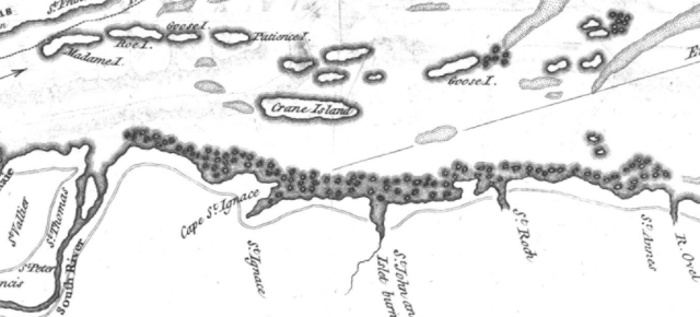
English: This is a detail from the source map, which is titled as follows: River St. Lawrence from Montréal to the Island of St. Barnaby... and the Island of Jeremy.
This detail shows a portion of the Saint Lawrence River east of Quebec City, showing locations of note in the March 1776 Battle of Saint-Pierre: Crane Island (Île-aux-Grues), St. Anne's (St.-Anne-de-la-Pocatiere), St. Thomas, and St. Peter (Saint-Pierre). |
|||||||||||||||||||
| Date | ||||||||||||||||||||
| Source |
URL at time of upload: http://services.banq.qc.ca/sdx/cep/document.xsp?app=ca.BAnQ.sdx.cep&db=notice&id=0002663585&n=9&dbrf0=xtgpleintexte_fr_FR&dbrv0=lawrence&sBtn=Lancer&qlang=fr-FR&db=notice&dbrn=1&sortfield=titre_trie&order=ascendant&col=america&chpp=20&dbrqp=search_notice&qid=sdx_q0 |
|||||||||||||||||||
| Author |
|
|||||||||||||||||||

Licensing
[edit]
|
This work is in the public domain in its country of origin and other countries and areas where the copyright term is the author's life plus 100 years or fewer. | |
| This file has been identified as being free of known restrictions under copyright law, including all related and neighboring rights. | |
File history
Click on a date/time to view the file as it appeared at that time.
| Date/Time | Thumbnail | Dimensions | User | Comment | |
|---|---|---|---|---|---|
| current | 02:24, 13 February 2009 | | 1,105 × 500 (450 KB) | Magicpiano (talk | contribs) | {{Information |Description={{en|1=This is a detail from the source map, which is titled as follows: River St. Lawrence from Montréal to the Island of St. Barnaby... and the Island of Jeremy. This detail shows a portion of the Saint Lawrence River east o |
You cannot overwrite this file.
File usage on Commons
There are no pages that use this file.
File usage on other wikis
The following other wikis use this file:
- Usage on en.wikipedia.org
- Usage on fr.wikipedia.org
- Usage on it.wikipedia.org
- Usage on ja.wikipedia.org
- Usage on nl.wikipedia.org