File:Saharan Africa regions map.svg
Jump to navigation
Jump to search

Size of this PNG preview of this SVG file: 137 × 79 pixels. Other resolutions: 320 × 185 pixels | 640 × 369 pixels | 1,024 × 590 pixels | 1,280 × 738 pixels | 2,560 × 1,476 pixels.
Original file (SVG file, nominally 137 × 79 pixels, file size: 2.25 MB)
Captions
Captions
Add a one-line explanation of what this file represents
Summary
[edit]
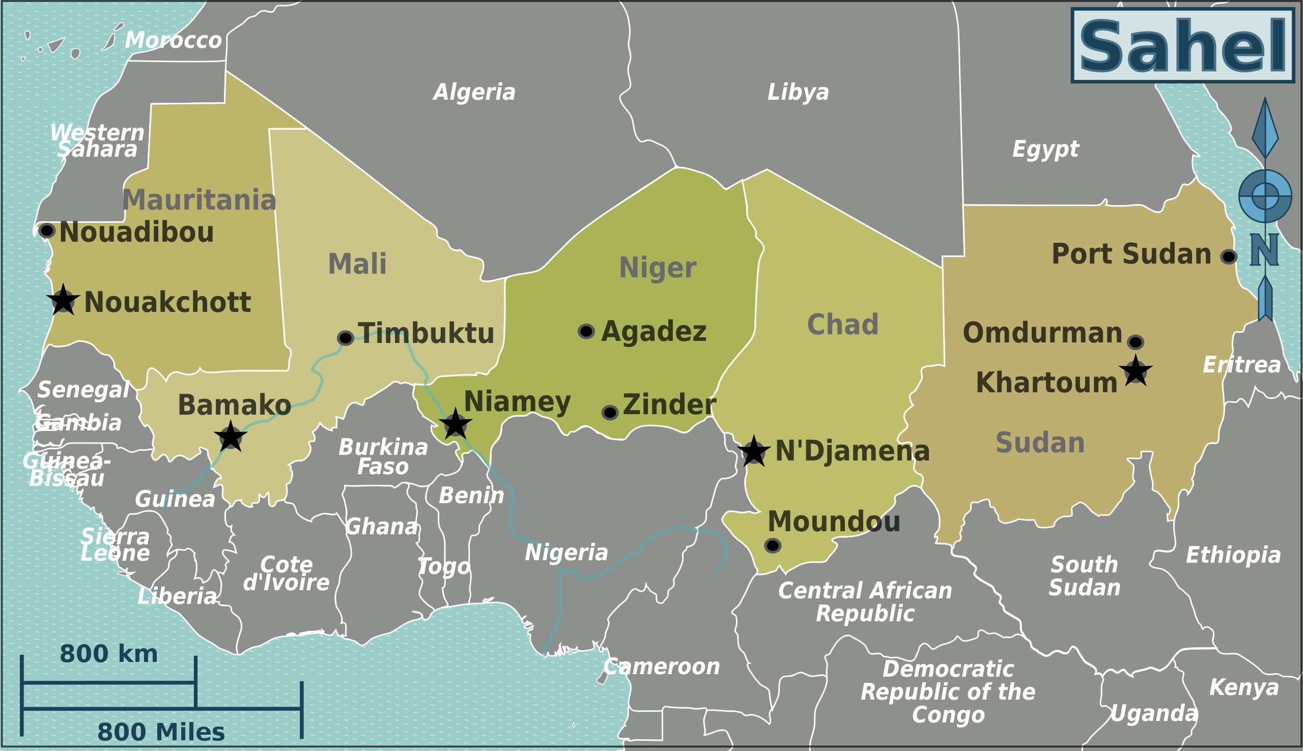
| Description | Map of Saharan Africa for use on Wikivoyage, multilingual SVG file |
| Date | |
| Source | Own work based on the blank worldmap |
| Author | Peter Fitzgerald, amendments by LtPowers and Burmesedays, French translation by Joelf |
| Other versions |
PNG files in different languages: |
.png)
.png)
.png)
Licensing
[edit]
This file is licensed under the Creative Commons Attribution-Share Alike 3.0 Unported license.
- You are free:
- to share – to copy, distribute and transmit the work
- to remix – to adapt the work
- Under the following conditions:
- attribution – You must give appropriate credit, provide a link to the license, and indicate if changes were made. You may do so in any reasonable manner, but not in any way that suggests the licensor endorses you or your use.
- share alike – If you remix, transform, or build upon the material, you must distribute your contributions under the same or compatible license as the original.
Original upload log
[edit]
| This file was imported from Wikivoyage WTS. |
The original description page was here. All following user names refer to wts.wikivoyage-old.
- 2008-08-10 03:59 (WT-shared) Peterfitzgerald archive copy at the Wayback Machine 940×477 (2709267 bytes) {{Imagecredit|credit=Peter Fitzgerald|captureDate=9 August 2008|location=Africa|source=[[:Image:BlankMap-World6.svg]]|caption=Africa regions (Import from wikitravel.org/shared)
- 2010-01-29 21:56 (WT-shared) Peterfitzgerald archive copy at the Wayback Machine 940×477 (2128284 bytes) Saharan Africa -> Sahel, per talk (Import from wikitravel.org/shared)
- 2010-12-24 03:14 (WT-shared) Joelf[dead link] 135×77 (2208296 bytes) +fr (Import from wikitravel.org/shared)
- 2010-12-24 03:37 (WT-shared) Joelf[dead link] 135×77 (2208200 bytes) Afrique du Sahara -> Sahel in fr version (Import from wikitravel.org/shared)
- 2011-07-22 05:55 (WT-shared) Burmesedays[dead link] 135×77 (2215401 bytes) minus South Sudan (Import from wikitravel.org/shared)
- 2011-07-22 13:40 (WT-shared) LtPowers[dead link] 137×79 (2355260 bytes) Remove Juba, re-arrange text slightly for aesthetics, fix capital city stars, add South Sudan in French and Russian. (Import from wikitravel.org/shared)
File history
Click on a date/time to view the file as it appeared at that time.
| Date/Time | Thumbnail | Dimensions | User | Comment | |
|---|---|---|---|---|---|
| current | 05:02, 19 December 2012 | | 137 × 79 (2.25 MB) | OgreBot (talk | contribs) | (BOT): Reverting to most recent version before archival |
| 05:02, 19 December 2012 |  | 135 × 77 (2.11 MB) | OgreBot (talk | contribs) | (BOT): Uploading old version of file from wts.wikivoyage; originally uploaded on 2011-07-22 05:55:47 by (WT-shared) Burmesedays | |
| 05:02, 19 December 2012 |  | 135 × 77 (2.11 MB) | OgreBot (talk | contribs) | (BOT): Uploading old version of file from wts.wikivoyage; originally uploaded on 2010-12-24 03:37:15 by (WT-shared) Joelf | |
| 05:02, 19 December 2012 |  | 135 × 77 (2.11 MB) | OgreBot (talk | contribs) | (BOT): Uploading old version of file from wts.wikivoyage; originally uploaded on 2010-12-24 03:14:57 by (WT-shared) Joelf | |
| 05:02, 19 December 2012 |  | 940 × 477 (2.03 MB) | OgreBot (talk | contribs) | (BOT): Uploading old version of file from wts.wikivoyage; originally uploaded on 2010-01-29 21:56:00 by (WT-shared) Peterfitzgerald | |
| 05:02, 19 December 2012 |  | 940 × 477 (2.58 MB) | OgreBot (talk | contribs) | (BOT): Uploading old version of file from wts.wikivoyage; originally uploaded on 2008-08-10 03:59:24 by (WT-shared) Peterfitzgerald | |
| 02:21, 18 November 2012 |  | 137 × 79 (2.25 MB) | MGA73bot2 (talk | contribs) | {{BotMoveToCommons|wts.oldwikivoyage|year={{subst:CURRENTYEAR}}|month={{subst:CURRENTMONTHNAME}}|day={{subst:CURRENTDAY}}}} == {{int:filedesc}} == {{Information |description=Saharan Africa regions map. , Saharan Africa * Map of: Saharan Africa¤ |date=... |
You cannot overwrite this file.
File usage on Commons
There are no pages that use this file.