File:Saharan Africa regions map.png
Jump to navigation
Jump to search
Size of this preview: 800 × 460 pixels. Other resolutions: 320 × 184 pixels | 640 × 368 pixels | 1,024 × 588 pixels | 1,280 × 735 pixels | 2,000 × 1,149 pixels.
Original file (2,000 × 1,149 pixels, file size: 528 KB, MIME type: image/png)
Captions
Captions
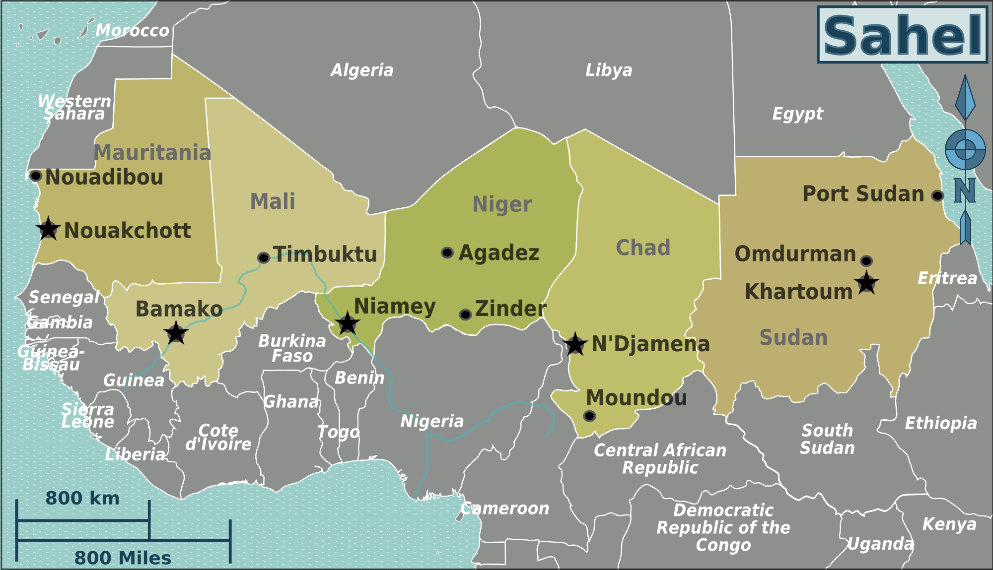
The Sahel Region refers a semi-dry zone of land in Northern Africa that stretches across ten countries from the Atlantic Ocean in the west to the Red Sea in the east.
Summary
[edit]
| Description | Map of Saharan Africa for use on Wikivoyage, English version |
| Date | |
| Source | Own work based on the blank worldmap |
| Author | Peter Fitzgerald, amendments by LtPowers |
| Other versions |
.png)
.png)
.png)
Licensing
[edit]
This file is licensed under the Creative Commons Attribution-Share Alike 3.0 Unported license.
- You are free:
- to share – to copy, distribute and transmit the work
- to remix – to adapt the work
- Under the following conditions:
- attribution – You must give appropriate credit, provide a link to the license, and indicate if changes were made. You may do so in any reasonable manner, but not in any way that suggests the licensor endorses you or your use.
- share alike – If you remix, transform, or build upon the material, you must distribute your contributions under the same or compatible license as the original.
Original upload log
[edit]
| This file was imported from Wikivoyage WTS. |
The original description page was here. All following user names refer to wts.wikivoyage-old.
- 2008-08-10 04:01 (WT-shared) Peterfitzgerald archive copy at the Wayback Machine 3008×1731 (809780 bytes) {{Imagecredit|credit=Peter Fitzgerald|captureDate=9 August 2008|location=Africa|source=[[:Image:Saharan Africa regions map.svg]]|caption=Afr (Import from wikitravel.org/shared)
- 2008-08-12 20:31 (WT-shared) Peterfitzgerald archive copy at the Wayback Machine 3008×1731 (809780 bytes) {{Imagecredit|credit=Peter Fitzgerald|captureDate=12 August 2008|location=Africa|source=[[:Image:West Africa regions map.svg]]|caption=Afric (Import from wikitravel.org/shared)
- 2008-08-12 20:33 (WT-shared) Peterfitzgerald archive copy at the Wayback Machine 3008×1731 (809780 bytes) Reverted to version as of 04:01, 10 August 2008 (Import from wikitravel.org/shared)
- 2010-01-29 21:55 (WT-shared) Peterfitzgerald archive copy at the Wayback Machine 3399×1953 (971572 bytes) Saharan Africa -> Sahel, per talk (Import from wikitravel.org/shared)
- 2011-07-22 05:52 (WT-shared) Burmesedays[dead link] 2000×1149 (545411 bytes) minus South Sudan (Import from wikitravel.org/shared)
- 2011-07-22 13:37 (WT-shared) LtPowers[dead link] 2000×1149 (464970 bytes) Remove Juba, re-arrange text slightly for aesthetics, fix capital city stars (Import from wikitravel.org/shared)
- 2011-07-22 13:39 (WT-shared) LtPowers[dead link] 2000×1149 (540406 bytes) Adjust document "page" location to match the framing of the map. (Import from wikitravel.org/shared)
File history
Click on a date/time to view the file as it appeared at that time.
| Date/Time | Thumbnail | Dimensions | User | Comment | |
|---|---|---|---|---|---|
| current | 05:02, 19 December 2012 | | 2,000 × 1,149 (528 KB) | OgreBot (talk | contribs) | (BOT): Reverting to most recent version before archival |
| 05:02, 19 December 2012 |  | 2,000 × 1,149 (454 KB) | OgreBot (talk | contribs) | (BOT): Uploading old version of file from wts.wikivoyage; originally uploaded on 2011-07-22 13:37:07 by (WT-shared) LtPowers | |
| 05:02, 19 December 2012 |  | 2,000 × 1,149 (533 KB) | OgreBot (talk | contribs) | (BOT): Uploading old version of file from wts.wikivoyage; originally uploaded on 2011-07-22 05:52:57 by (WT-shared) Burmesedays | |
| 05:01, 19 December 2012 |  | 3,399 × 1,953 (949 KB) | OgreBot (talk | contribs) | (BOT): Uploading old version of file from wts.wikivoyage; originally uploaded on 2010-01-29 21:55:21 by (WT-shared) Peterfitzgerald | |
| 05:01, 19 December 2012 |  | 3,008 × 1,731 (791 KB) | OgreBot (talk | contribs) | (BOT): Uploading old version of file from wts.wikivoyage; originally uploaded on 2008-08-10 04:01:29 by (WT-shared) Peterfitzgerald | |
| 02:21, 18 November 2012 |  | 2,000 × 1,149 (528 KB) | MGA73bot2 (talk | contribs) | {{BotMoveToCommons|wts.oldwikivoyage|year={{subst:CURRENTYEAR}}|month={{subst:CURRENTMONTHNAME}}|day={{subst:CURRENTDAY}}}} == {{int:filedesc}} == {{Information |description=Africa regions map. , Saharan Africa * Map of: Saharan Africa¤ |date=9 August... |
You cannot overwrite this file.
File usage on Commons
There are no pages that use this file.
File usage on other wikis
The following other wikis use this file:
- Usage on de.wikivoyage.org
- Usage on el.wikivoyage.org
- Usage on en.wikivoyage.org
- Usage on fa.wikivoyage.org
- Usage on fi.wikivoyage.org
- Usage on he.wikivoyage.org
- Usage on incubator.wikimedia.org
- Usage on it.wikivoyage.org
- Usage on ja.wikivoyage.org
- Usage on nl.wikivoyage.org
- Usage on pl.wikivoyage.org
- Usage on pt.wikivoyage.org
- Usage on ru.wikivoyage.org
- Usage on zh.wikivoyage.org