File:Sagarmatha National Park-Gorak Shep to Pheriche 2013-05-06 08-10-23-2013-05-06 08-11-08.jpg
Jump to navigation
Jump to search
Size of this preview: 800 × 195 pixels. Other resolutions: 320 × 78 pixels | 640 × 156 pixels | 1,024 × 249 pixels | 3,287 × 800 pixels.
Original file (3,287 × 800 pixels, file size: 664 KB, MIME type: image/jpeg)
Captions
Captions
Add a one-line explanation of what this file represents
Summary
[edit]| Description |
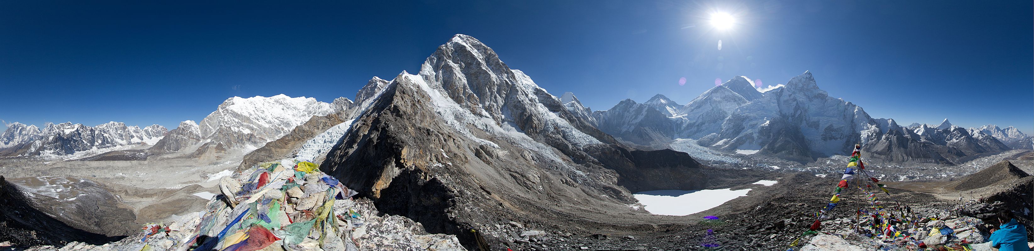
English: A view from the Mount Everest Base Camp(Altitude of 5,364 metres (17,598 ft)) - Gorak Shep to Pheriche . नेपाली: सगरमाथा आधार शिविरवाट देखिएको गोरकशेप देखि फेरिच्चे सम्मको एक मनोरम दृश्य ।
|
||
| Date | |||
| Source | Own work | ||
| Author | Thomas Fuhrmann | ||
| Other versions |

.jpg)
| Camera location | | View this and other nearby images on: OpenStreetMap |
|---|
Canon Eos 7d, Thomas Fuhrmann, www.snowmanstudios.de
Licensing
[edit]
I, the copyright holder of this work, hereby publish it under the following license:
This file is licensed under the Creative Commons Attribution-Share Alike 3.0 Unported license.
- You are free:
- to share – to copy, distribute and transmit the work
- to remix – to adapt the work
- Under the following conditions:
- attribution – You must give appropriate credit, provide a link to the license, and indicate if changes were made. You may do so in any reasonable manner, but not in any way that suggests the licensor endorses you or your use.
- share alike – If you remix, transform, or build upon the material, you must distribute your contributions under the same or compatible license as the original.
This image was uploaded as part of Wiki Loves Earth 2014.
|
 |

|
This image won the 2nd prize in the national contest of Nepal in Wiki Loves Earth 2014 Other languages:
|
This image has been assessed using the Quality image guidelines and is considered a Quality image.
|
| Annotations | This image is annotated: View the annotations at Commons |
File history
Click on a date/time to view the file as it appeared at that time.
| Date/Time | Thumbnail | Dimensions | User | Comment | |
|---|---|---|---|---|---|
| current | 08:03, 24 May 2014 | 3,287 × 800 (664 KB) | Snowmanstudios (talk | contribs) | User created page with UploadWizard |
You cannot overwrite this file.
File usage on Commons
The following 10 pages use this file:
- User:John Cummings/exhibition/natural
- User:John Cummings/sandboximages7
- User:Snowmanstudios
- User talk:Snowmanstudios
- Commons:Quality images/Subject/Places/Natural structures/Panorama/Archive 2018-2019
- Commons:Quality images candidates/Archives November 13 2018
- Commons:Wiki Loves Earth 2014/Winners
- Commons:Wiki Loves Earth 2014 in Nepal/Winners
- File:Khumbu wikivoyage banner.jpg
- File:Sagarmatha National Park (cropped).jpg
File usage on other wikis
The following other wikis use this file:
- Usage on bn.wikipedia.org
- Usage on bs.wikipedia.org
- Usage on ca.wikipedia.org
- Usage on ckb.wikipedia.org
- Usage on de.wikipedia.org
- Usage on dty.wikipedia.org
- Usage on en.wikipedia.org
- Usage on es.wikipedia.org
- Usage on hi.wikipedia.org
- Usage on it.wikipedia.org
- Usage on it.wikivoyage.org
- Usage on ja.wikipedia.org
- Usage on mai.wikipedia.org
- Usage on min.wikipedia.org
- Usage on ne.wikipedia.org
- Usage on pa.wikipedia.org
- Usage on ta.wikipedia.org
- Usage on uk.wikipedia.org
- Usage on zh.wikipedia.org
Metadata
Categories:
- Gorak Shep to Pheriche
- Pumori
- Lingtren
- Khumbutse
- Changtse
- Views of Mount Everest from Kala Patthar
- Nuptse
- Khumbu Glacier
- Khangri Shar
- Chumbu
- Panoramics in Solukhumbu District
- Kala Patthar
- Valley glaciers of Nepal
- Icefalls in Nepal
- Confluences of glaciers in Nepal
- Prayer flags in Nepal
- Ice-marginal lakes in Nepal
- Lens flares
- Contre-jour photographs of landscapes
- Snow in Nepal in May
- Mountains with snow in Nepal
- Lobuche
- Nirekha