File:SEPTA Regional Rail Diagram.svg
Jump to navigation
Jump to search

Size of this PNG preview of this SVG file: 602 × 599 pixels. Other resolutions: 241 × 240 pixels | 482 × 480 pixels | 772 × 768 pixels | 1,029 × 1,024 pixels | 2,057 × 2,048 pixels | 1,760 × 1,752 pixels.
Original file (SVG file, nominally 1,760 × 1,752 pixels, file size: 1.27 MB)
Captions
Captions
Add a one-line explanation of what this file represents
Summary
[edit]
| Description |
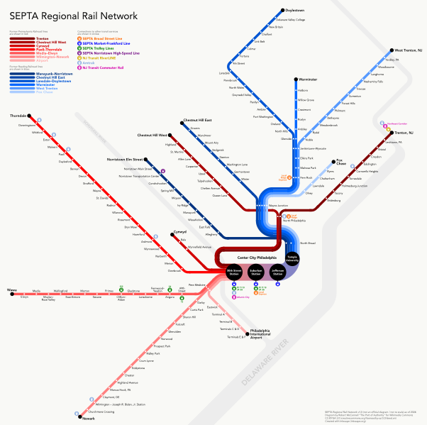
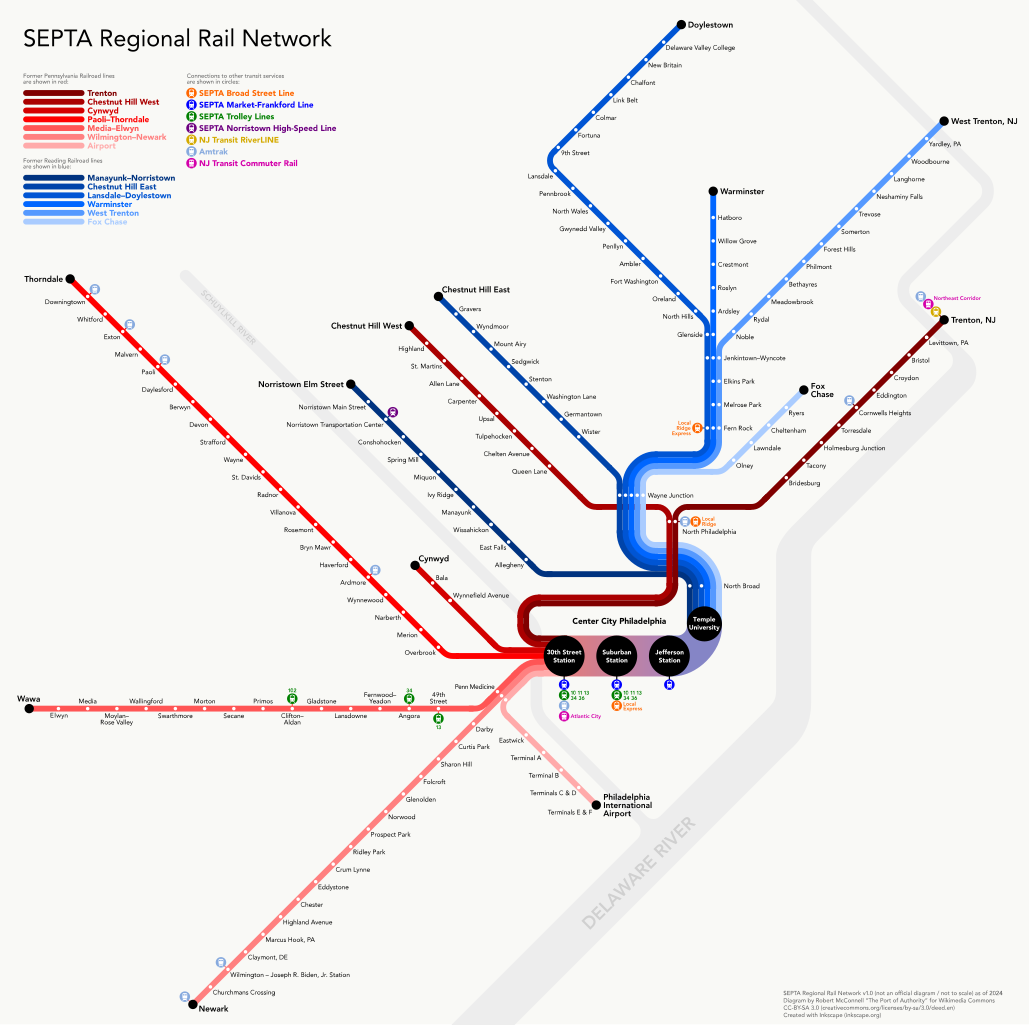
English: Diagram of the SEPTA Regional Rail network in Philadelphia and its environs. Current as of March 2024. |
| Date |
(original version) 12 March 2024 (latest version) |
| Source | Own work |
| Author | The Port of Authority |
Licensing
[edit]
I, the copyright holder of this work, hereby publish it under the following license:
This file is licensed under the Creative Commons Attribution-Share Alike 3.0 Unported license.
- You are free:
- to share – to copy, distribute and transmit the work
- to remix – to adapt the work
- Under the following conditions:
- attribution – You must give appropriate credit, provide a link to the license, and indicate if changes were made. You may do so in any reasonable manner, but not in any way that suggests the licensor endorses you or your use.
- share alike – If you remix, transform, or build upon the material, you must distribute your contributions under the same or compatible license as the original.
File history
Click on a date/time to view the file as it appeared at that time.
| Date/Time | Thumbnail | Dimensions | User | Comment | |
|---|---|---|---|---|---|
| current | 23:02, 12 March 2024 | | 1,760 × 1,752 (1.27 MB) | Pi.1415926535 (talk | contribs) | University City --> Penn Medicine |
| 03:24, 7 March 2024 |  | 512 × 510 (1 MB) | Pi.1415926535 (talk | contribs) | Add Wawa; correct Lansdale/Doylestown stopping pattern | |
| 04:22, 10 May 2017 |  | 512 × 510 (1,009 KB) | Train2104 (talk | contribs) | Additional Amtrak stations, 9th Street station | |
| 21:38, 30 April 2015 |  | 1,760 × 1,720 (2.66 MB) | Dream out loud (talk | contribs) | updated Center City station names | |
| 05:40, 16 January 2013 |  | 1,760 × 1,720 (2.78 MB) | Dream out loud (talk | contribs) | fixed order of Overbrook and Merion stations, other minor tweaks and fixes | |
| 04:48, 7 January 2013 |  | 1,760 × 1,720 (2.77 MB) | The Port of Authority (talk | contribs) | User created page with UploadWizard |
You cannot overwrite this file.
File usage on Commons
The following 13 pages use this file:
- User:Chumwa/OgreBot/Potential transport maps/2017 May 1-10
- User:Chumwa/OgreBot/Public transport information/2015 April 21-30
- User:Chumwa/OgreBot/Public transport information/2017 May 1-10
- User:Chumwa/OgreBot/Public transport information/2024 March 1-10
- User:Chumwa/OgreBot/Public transport information/2024 March 11-20
- User:Chumwa/OgreBot/Transport Maps/2015 April 21-30
- User:Chumwa/OgreBot/Transport Maps/2017 May 1-10
- User:Chumwa/OgreBot/Transport Maps/2024 March 1-10
- User:Chumwa/OgreBot/Transport Maps/2024 March 11-20
- User:Chumwa/OgreBot/Travel and communication maps/2017 May 1-10
- User:GeorgR (de)/Rail Transport in the US/2024 March
- Category:SEPTA Regional Rail
- Category:Train stations of SEPTA Regional Rail
File usage on other wikis
The following other wikis use this file:
- Usage on en.wikipedia.org
- Usage on es.wikipedia.org
- Usage on it.wikipedia.org
- Usage on ko.wikipedia.org
- Usage on www.wikidata.org