File:SE2017Aug21TLUSA.svg
Jump to navigation
Jump to search

Size of this PNG preview of this SVG file: 800 × 422 pixels. Other resolutions: 320 × 169 pixels | 640 × 338 pixels | 1,024 × 540 pixels | 1,280 × 675 pixels | 2,560 × 1,350 pixels | 2,048 × 1,080 pixels.
Original file (SVG file, nominally 2,048 × 1,080 pixels, file size: 3.2 MB)
Captions
Captions
Add a one-line explanation of what this file represents
Summary
[edit]
| Description |
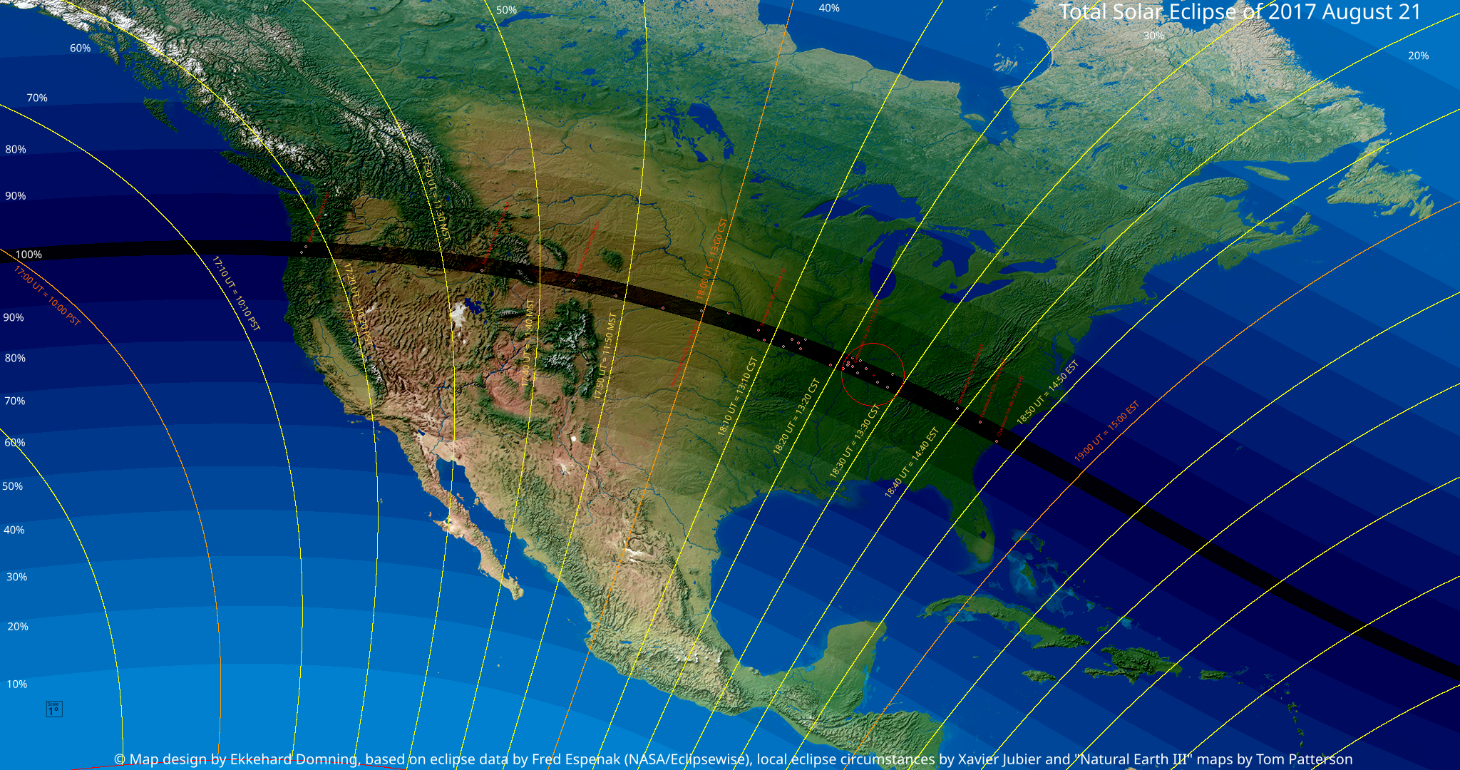
English: Local of the Solar eclipse of August 21, 2017, North America. Scale 1px = 2'40" (360°=8100px)
Deutsch: Karte von Nordamerika, den zentralen Teil der Sonnenfinsternis vom 21. August 2017 enthaltend. Maßstab 1px = 2'40" (360°=8100px) |
| Date | |
| Source | Own work Map design by Ekkehard Domning, based on eclipse data by Fred Espenak (NASA/Eclipsewise), local eclipse circumstances by Xavier Jubier and "Natural Earth III" maps by Tom Patterson. |
| Author | EkkehardDomning |
Licensing
[edit]
I, the copyright holder of this work, hereby publish it under the following license:
This file is licensed under the Creative Commons Attribution-Share Alike 4.0 International license.
- You are free:
- to share – to copy, distribute and transmit the work
- to remix – to adapt the work
- Under the following conditions:
- attribution – You must give appropriate credit, provide a link to the license, and indicate if changes were made. You may do so in any reasonable manner, but not in any way that suggests the licensor endorses you or your use.
- share alike – If you remix, transform, or build upon the material, you must distribute your contributions under the same or compatible license as the original.
File history
Click on a date/time to view the file as it appeared at that time.
| Date/Time | Thumbnail | Dimensions | User | Comment | |
|---|---|---|---|---|---|
| current | 10:00, 20 November 2015 | | 2,048 × 1,080 (3.2 MB) | EkkehardDomning (talk | contribs) | {{Information |Description ={{en|1=Local of the Solar eclipse of August 21, 2017, North America }} {{de|1=Karte von Nordamerika, den zentralen Teil der Sonnenfinsternis vom 21. August 2017 enthaltend}} |Source ={{own}} |Author =[[Use... |
You cannot overwrite this file.
File usage on Commons
There are no pages that use this file.
File usage on other wikis
The following other wikis use this file:
- Usage on de.wikipedia.org