File:SAYPE Bridges 2024 Fribourg 05.jpg

Original file (3,991 × 1,886 pixels, file size: 4.49 MB, MIME type: image/jpeg)
Captions
Captions
 This media file has been nominated for deletion since 27 August 2024. To discuss it, please visit the nomination page.
Do not remove this tag until the deletion nomination is closed. Reason for the nomination: copyright violation; contemporary artwork; no freedom of panorama (due to non-permanence)
| |||
Show further instructions
If this template was added because you clicked "Mark for deletion" in the left menu (right when using Vector 2022 skin), please make sure that all necessary pages have been created. If they haven't been created after a few minutes, or if you added this template manually, you should complete these steps:
{{subst:delete2|image=Files in Category:Saype|reason=copyright violation; contemporary artwork; no freedom of panorama (due to non-permanence)}} ~~~~
For mass deletions: If you want to nominate several related images, please make a mass request by manually adding Note: This template is for requests that may require discussion in order to be deleted. For speedy deletions, you can use
| |||
Summary
[edit]| DescriptionSAYPE Bridges 2024 Fribourg 05.jpg |
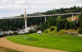
Deutsch: Das Landart-Werk Brücken? von SAYPE aus einer Seitenperspektive auf dem Weg in Les Neigles, Freiburg, Schweiz
Français : L'œuvre de land art Ponts ? de SAYPE vue de côté sur le chemin des Neigles, Fribourg, Suisse
English: The land art work Bridges? by SAYPE from a side perspective on the path in Les Neigles, Fribourg, Switzerland
Español: La obra de land art ¿Puentes? de SAYPE desde una perspectiva lateral en el camino de Les Neigles, Friburgo, Suiza. |
||
| Date | |||
| Source | Own work | ||
| Author | Martin Thurnherr | ||
| Permission (Reusing this file) |
|
||
| Other versions |
|
||
| Panorama InfoField |
|
| Object location | 46° 48′ 43.31″ N, 7° 09′ 52.27″ E | View this and other nearby images on: OpenStreetMap |
|---|
| Camera location | 46° 48′ 39.29″ N, 7° 09′ 54.22″ E | View this and other nearby images on: OpenStreetMap |
|---|
Licensing
[edit]- You are free:
- to share – to copy, distribute and transmit the work
- to remix – to adapt the work
- Under the following conditions:
- attribution – You must give appropriate credit, provide a link to the license, and indicate if changes were made. You may do so in any reasonable manner, but not in any way that suggests the licensor endorses you or your use.
- share alike – If you remix, transform, or build upon the material, you must distribute your contributions under the same or compatible license as the original.
File history
Click on a date/time to view the file as it appeared at that time.
| Date/Time | Thumbnail | Dimensions | User | Comment | |
|---|---|---|---|---|---|
| current | 16:23, 21 August 2024 |  | 3,991 × 1,886 (4.49 MB) | Matutinho (talk | contribs) | Uploaded own work with UploadWizard |
You cannot overwrite this file.
File usage on Commons
The following 4 pages use this file:
Metadata
This file contains additional information such as Exif metadata which may have been added by the digital camera, scanner, or software program used to create or digitize it. If the file has been modified from its original state, some details such as the timestamp may not fully reflect those of the original file. The timestamp is only as accurate as the clock in the camera, and it may be completely wrong.
| Camera manufacturer | Canon |
|---|---|
| Camera model | Canon EOS 500D |
| Author | |
| Copyright holder | |
| Date and time of data generation | 16:30, 20 August 2024 |
| User comments | Projection: Cylindrical (1)
FOV: 111 x 70 Ev: 11.62 |
| Horizontal resolution | 1 dpc |
| Vertical resolution | 1 dpc |
| Software used | Hugin 2021.0.0.52df0f76c700 built by Thomas |
| File change date and time | 16:30, 20 August 2024 |
| Y and C positioning | Centered |
| Exif version | 2.32 |
| Date and time of digitizing | 16:30, 20 August 2024 |
| Meaning of each component |
|
| Supported Flashpix version | 1 |
| Color space | sRGB |
| GPS tag version | 2.2.0.0 |


