File:S-Bahn-Zuerich-Linienplan.svg
Jump to navigation
Jump to search

Size of this PNG preview of this SVG file: 681 × 600 pixels. Other resolutions: 273 × 240 pixels | 545 × 480 pixels | 872 × 768 pixels | 1,163 × 1,024 pixels | 2,325 × 2,048 pixels | 948 × 835 pixels.
Original file (SVG file, nominally 948 × 835 pixels, file size: 458 KB)
Captions
Captions
Add a one-line explanation of what this file represents
Summary
[edit]
| Description |
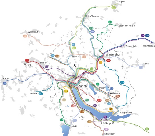
English: Unofficial map of Zurich S-Bahn as it stood between 2007 and June 2014
Deutsch: Liniennetz der S-Bahn Zürich |
| Date | |
| Source | Own work (sources used for my own drawing: official simplified map and other Swiss maps) |
| Author | Lukas Haefliger HaLu |
| Other versions | S-Bahn-Zuerich-Linienplan.png (pre 2008 in bitmap format) |
Licensing
[edit]
I, the copyright holder of this work, hereby publish it under the following licenses:

|
Permission is granted to copy, distribute and/or modify this document under the terms of the GNU Free Documentation License, Version 1.2 or any later version published by the Free Software Foundation; with no Invariant Sections, no Front-Cover Texts, and no Back-Cover Texts. A copy of the license is included in the section entitled GNU Free Documentation License. |
This file is licensed under the Creative Commons Attribution 3.0 Unported license.
- You are free:
- to share – to copy, distribute and transmit the work
- to remix – to adapt the work
- Under the following conditions:
- attribution – You must give appropriate credit, provide a link to the license, and indicate if changes were made. You may do so in any reasonable manner, but not in any way that suggests the licensor endorses you or your use.
You may select the license of your choice.
File history
Click on a date/time to view the file as it appeared at that time.
| Date/Time | Thumbnail | Dimensions | User | Comment | |
|---|---|---|---|---|---|
| current | 18:01, 7 August 2008 | | 948 × 835 (458 KB) | Dodo von den Bergen (talk | contribs) | == Summary == {{Information| |Description = {{en|Unofficial map of Zurich S-Bahn}} {{de|Liniennetz der S-Bahn Zürich}} |Source = self-made (sources used for my own drawing: official simplified map and other Swiss maps) |Date=2007-12-21 |Author= Lukas Hae |
| 22:29, 18 December 2007 |  | 948 × 835 (456 KB) | HaLu (talk | contribs) | Same width for all lines | |
| 20:25, 17 December 2007 |  | 960 × 915 (515 KB) | HaLu (talk | contribs) | Minor size corrections | |
| 20:18, 17 December 2007 |  | 956 × 914 (464 KB) | HaLu (talk | contribs) | {{Information| |Description = {{en|Unofficial map of Zurich S-Bahn}} {{de|Liniennetz der S-Bahn Zürich}} |Source = self-made (sources used for my own drawing: official simplified map and other Swiss maps) |Date=2007-12-21 |Author= Lukas Haefliger [[User: | |
| 11:16, 8 December 2007 |  | 995 × 914 (813 KB) | HaLu (talk | contribs) | {{Information| |Description = Unofficial map of Zurich S-Bahn {{de|Liniennetz der S-Bahn Zürich}} |Source = self-made (sources used for my own drawing: official simplified map and other Swiss maps)[[Category:[[Category:]]]] |Date=2007-12-07 |Author= Luka |
You cannot overwrite this file.
File usage on Commons
The following page uses this file:
File usage on other wikis
The following other wikis use this file:
- Usage on de.wikipedia.org