File:Södertörnsleden ny sträckning 2011.jpg
Jump to navigation
Jump to search

Size of this preview: 800 × 591 pixels. Other resolutions: 320 × 236 pixels | 640 × 472 pixels | 1,024 × 756 pixels | 1,268 × 936 pixels.
Original file (1,268 × 936 pixels, file size: 443 KB, MIME type: image/jpeg)
Captions
Captions
Add a one-line explanation of what this file represents
Summary
[edit]
| Description |
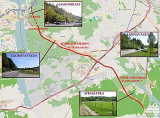
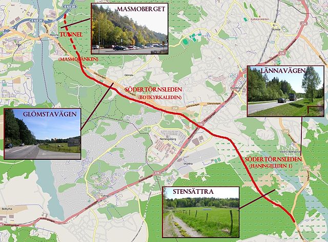
Svenska: Södertörnsledens västra del mellan Gladö kvarn och Fittja (planerad vägsträckning) |
| Date | |
| Source | Own work (grafik och fyra bilder), kartan är hämtat från Open street map |
| Author | Holger.Ellgaard |
| Description |
This map was created from OpenStreetMap project data, collected by the community. This map may be incomplete, and may contain errors. Don't rely solely on it for navigation. |
| Date | (see file history) |
| Source | You may find a page on the OpenStreetMap wiki page for Södertörnsleden |
| Creator |
OpenStreetMap contributors |
| Permission (Reusing this file) |
OpenStreetMap data and maps are licensed under the Creative Commons Attribution-ShareAlike 2.0 license (CC-BY-SA 2.0). This file is licensed under the Creative Commons Attribution-Share Alike 2.0 Generic license.
|
| Georeferencing | If inappropriate please set warp_status = skip to hide. |
Licensing
[edit]
I, the copyright holder of this work, hereby publish it under the following license:
| This file is made available under the Creative Commons CC0 1.0 Universal Public Domain Dedication. | |
| The person who associated a work with this deed has dedicated the work to the public domain by waiving all of their rights to the work worldwide under copyright law, including all related and neighboring rights, to the extent allowed by law. You can copy, modify, distribute and perform the work, even for commercial purposes, all without asking permission.
|
File history
Click on a date/time to view the file as it appeared at that time.
| Date/Time | Thumbnail | Dimensions | User | Comment | |
|---|---|---|---|---|---|
| current | 07:40, 21 May 2011 | | 1,268 × 936 (443 KB) | Holger.Ellgaard (talk | contribs) | utökning |
| 15:33, 20 May 2011 |  | 1,268 × 936 (441 KB) | Holger.Ellgaard (talk | contribs) | {{Information |Description ={{sv|1=Södertörnsledens västra del mellan Gladö kvarn och Fittja (planerad vägsträckning)}} |Source ={{own}} (grafik och fyra bilder), kartan är hämtat från Open street map |Author =[[User:Holger.Ell |
You cannot overwrite this file.
File usage on Commons
There are no pages that use this file.