File:Sö211 Ljunga - kmb.16000300019605.jpg
Jump to navigation
Jump to search

Size of this preview: 400 × 600 pixels. Other resolutions: 160 × 240 pixels | 512 × 768 pixels.
Original file (512 × 768 pixels, file size: 166 KB, MIME type: image/jpeg)
Captions
Captions
Add a one-line explanation of what this file represents
| Sö211 Ljunga
( |
|||||||||||||||||||||||||||
|---|---|---|---|---|---|---|---|---|---|---|---|---|---|---|---|---|---|---|---|---|---|---|---|---|---|---|---|
| Photographer |
Bengt A. Lundberg |
||||||||||||||||||||||||||
| Title |
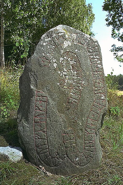
Sö211 Ljunga |
||||||||||||||||||||||||||
| Original caption |
Notera Av dokumentationsskäl har originalbeskrivningen från Riksantikvarieämbetet behållits. Tillrättalägganden och alternativa beskrivningar bör införas separat från nedanstående information. Inskriften lyder: Stenulv och Hake och Tryrik och Öbjörn och Ovlate, de reste denna sten efter Ulv, fader.Felaktigheter kan även anmälas till denna sida. |
||||||||||||||||||||||||||
| Description |
|
||||||||||||||||||||||||||
| Depicted place | Sweden, Södermanland, Strängnäs, Överselö (Södermanland) | ||||||||||||||||||||||||||
| Date | 7 August 1997 | ||||||||||||||||||||||||||
| Collection |
|
||||||||||||||||||||||||||
| Accession number | |||||||||||||||||||||||||||
| Source | Kulturmiljöbild, Riksantikvarieämbetet | ||||||||||||||||||||||||||
| Permission (Reusing this file) |
|
||||||||||||||||||||||||||


| Object location | | View this and other nearby images on: OpenStreetMap |
|---|
File history
Click on a date/time to view the file as it appeared at that time.
| Date/Time | Thumbnail | Dimensions | User | Comment | |
|---|---|---|---|---|---|
| current | 07:53, 23 April 2015 | | 512 × 768 (166 KB) | Taxelson (talk | contribs) | Transferred from http://kmb.raa.se/cocoon/bild/raa-image/16000300019605/normal/1.jpg |
You cannot overwrite this file.
File usage on Commons
The following page uses this file:
File usage on other wikis
The following other wikis use this file:
- Usage on da.wikipedia.org
- Bruger:Palnatoke/Autolister/Runer/Runesten
- Bruger:Palnatoke/Autolister/Runer/Runesten i Rundata-nummerorden
- Bruger:Palnatoke/Autolister/Runer/Runeindskrifter
- Bruger:Palnatoke/Autolister/Runer/Runeindskrifter i Rundata-nummerorden
- Bruger:Palnatoke/Autolister/Runer/Runeindskrifter (rister og tekst)
- Bruger:Palnatoke/Autolister/Runer/Vikingeartefakter
- Usage on no.wikipedia.org
- Usage on sv.wikipedia.org
- Usage on www.wikidata.org