File:Ruta A35-Altos de Chacaya (1).jpg
Jump to navigation
Jump to search

Size of this preview: 800 × 600 pixels. Other resolutions: 320 × 240 pixels | 640 × 480 pixels | 1,024 × 768 pixels | 1,280 × 960 pixels | 2,560 × 1,920 pixels.
Original file (2,560 × 1,920 pixels, file size: 937 KB, MIME type: image/jpeg)
Captions
Captions
Add a one-line explanation of what this file represents
Summary
[edit].jpg&action=edit§ion=1)
| Description |
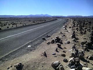
Español: La Ruta A-35 en el km 32,9 camino a Codpa en Altos de Chacaya a 2300 m s.n.m. Tradicional sitio ritual con "cargas" (pequeños montículos de piedra), hechos por viajeros para descargar en ellas sus fatigas y cansancios. Al fondo se ven los cerros Tulapalca (4406 m s.n.m.), Tangane (4735 m s.n.m.) y Marquez (4932 m s.n.m.) |
| Date | Taken on 18 May 2015, 11:31:59 (according to Exif data) |
| Source | Own work |
| Author | WeHaKa |
| Permission (Reusing this file) |
I, the copyright holder of this work, hereby publish it under the following license: This file is licensed under the Creative Commons Attribution-Share Alike 4.0 International license.
|
| Camera location | | View this and other nearby images on: OpenStreetMap |
|---|
.jpg¶ms=-18.875056_N_-069.722500_E_globe:Earth_type:camera_heading:67.50_region:CL-AP&language=en)
| Annotations | This image is annotated: View the annotations at Commons |
.jpg)
File history
Click on a date/time to view the file as it appeared at that time.
| Date/Time | Thumbnail | Dimensions | User | Comment | |
|---|---|---|---|---|---|
| current | 16:46, 16 July 2022 | | 2,560 × 1,920 (937 KB) | WeHaKa (talk | contribs) | {{Information |description = {{es|La Ruta A-35 en el km 32,9 camino a Codpa en Altos de Chacaya a 2300 m s.n.m. Tradicional sitio ritual con "cargas" (pequeños montículos de piedra), hechos por viajeros para descargar en ellas sus fatigas y cansancios. Al fondo se ven los cerros Tulapalca (4406 m s.n.m.), Tangane (4735 m s.n.m.) y Marquez (4932 m s.n.m.) }} |date = {{Taken on|2015-05-18 11:31:59|source=EXIF|location=Chile}} |source = {{own}} |author = [[User:... |
You cannot overwrite this file.
File usage on Commons
There are no pages that use this file.
File usage on other wikis
The following other wikis use this file:
- Usage on es.wikipedia.org
.jpg&oldid=835717077)