File:Russian Empire 1745 (Map IX HQ).jpg
Jump to navigation
Jump to search

Size of this preview: 683 × 599 pixels. Other resolutions: 274 × 240 pixels | 547 × 480 pixels | 875 × 768 pixels | 1,167 × 1,024 pixels | 2,334 × 2,048 pixels | 9,238 × 8,107 pixels.
Original file (9,238 × 8,107 pixels, file size: 10.08 MB, MIME type: image/jpeg)
Captions
Captions
Add a one-line explanation of what this file represents
| Warning | The original file is very high-resolution. It might not load properly or could cause your browser to freeze when opened at full size. |
|---|
Summary
[edit]| Description |
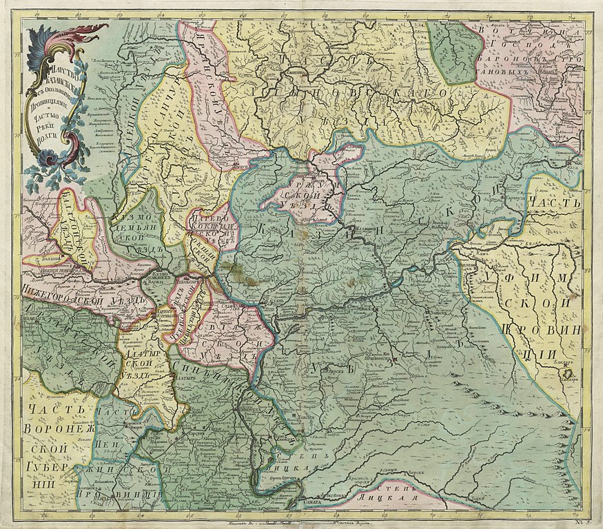
Русский: Первый официальный атлас Российской империи (1745). Царство Казанское с окольными провинциями и частью реки Волги. Оригинальная карта гравирована на меди и раскрашена вручную акварелью.
English: First official geographic atlas of the Russian Empire (1745). Map of Kazan governorate, nearest provinces and part of Volga river. Hand-coloured copper engraving. |
| Date | |
| Source |
Русский: Атлас Российский (1745), цифровая копия сделана Российской государственной библиотекой (http://www.rsl.ru)
English: Geographic atlas of the Russian Empire (1745), digital copy made by Russian State Library (http://www.rsl.ru/en) |
| Author | РАН (Russian Academy of Science) |
| Other versions |
Derivative works of this file: Russian Empire 1745 (Map IX HQ).Simbirskaja cherta.jpg
|
.jpg)
.jpg)
.jpg&flash=no)
.jpg&action=edit§ion=1)
.Simbirskaja_cherta.jpg)
Licensing
[edit].jpg&action=edit§ion=2)
|
This work is in the public domain in its country of origin and other countries and areas where the copyright term is the author's life plus 100 years or fewer. | |
| This file has been identified as being free of known restrictions under copyright law, including all related and neighboring rights. | |
File history
Click on a date/time to view the file as it appeared at that time.
| Date/Time | Thumbnail | Dimensions | User | Comment | |
|---|---|---|---|---|---|
| current | 12:12, 15 November 2009 | | 9,238 × 8,107 (10.08 MB) | Transcend (rus) (talk | contribs) | == {{int:filedesc}} == {{Information |Description= {{ru|1=Первый официальный атлас Российской империи (1745). Царство Казанское с окольными провинциями и частью реки В |
You cannot overwrite this file.
File usage on Commons
The following 3 pages use this file:
File usage on other wikis
The following other wikis use this file:
- Usage on bg.wikipedia.org
- Usage on es.wikipedia.org
- Usage on ru.wikipedia.org
- Строгановы
- Вотчина
- Приказ Казанского дворца
- Арская даруга
- Казанский уезд
- Свияжский уезд
- История изменений в административно-территориальном делении Тольятти (Ставрополя) и Ставропольского района
- Симбирский уезд
- Ивановское (Большемурашкинский район)
- Чувашская даруга
- Приказанские и заказанские чуваши XVI-XVIII веков
- Usage on tt.wikipedia.org
- Usage on uk.wikipedia.org
- Usage on www.wikidata.org
.jpg&oldid=508179322)