File:Russian-occupied territories in map.jpg
Jump to navigation
Jump to search
Size of this preview: 800 × 403 pixels. Other resolutions: 320 × 161 pixels | 640 × 323 pixels | 1,024 × 516 pixels | 1,280 × 645 pixels | 3,840 × 1,935 pixels.
Original file (3,840 × 1,935 pixels, file size: 640 KB, MIME type: image/jpeg)
Captions
Captions
Add a one-line explanation of what this file represents

|
File:Russian occupied territories in map.svg is a vector version of this file. It should be used in place of this JPG file when not inferior.
File:Russian-occupied territories in map.jpg → File:Russian occupied territories in map.svg
For more information, see Help:SVG. |
 |
Summary
[edit]
| Description |
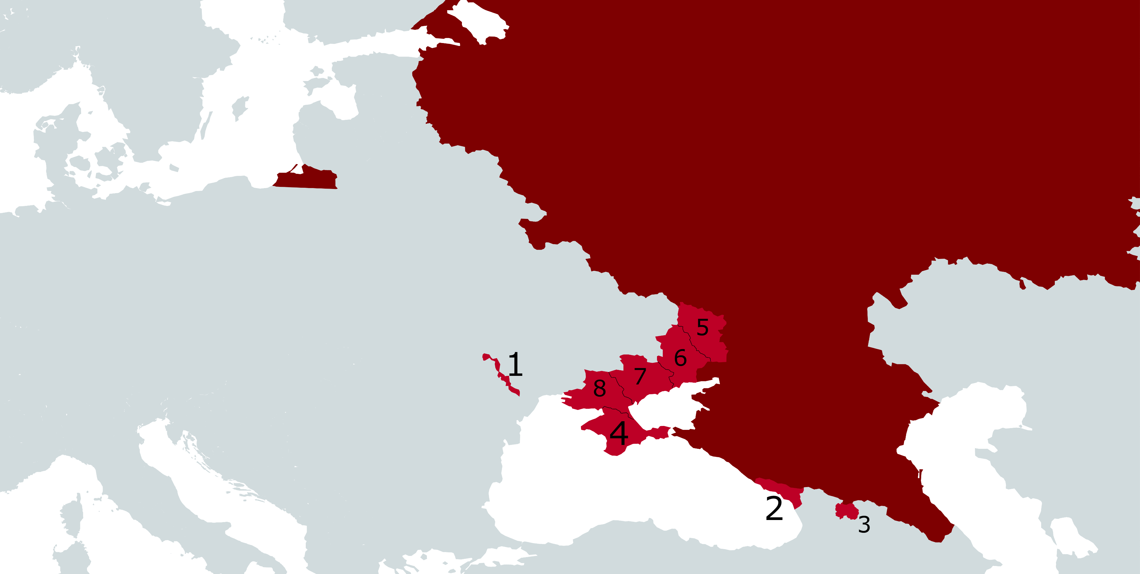
English: Map showing Russia in dark red with Russian-occupied territories in Europe in light red, as follows:
|
| Date | |
| Source |
Own work. Compare:
|
| Author | Gabriel Ziegler |
Licensing
[edit]
I, the copyright holder of this work, hereby publish it under the following license:
This file is licensed under the Creative Commons Attribution-Share Alike 4.0 International license.
- You are free:
- to share – to copy, distribute and transmit the work
- to remix – to adapt the work
- Under the following conditions:
- attribution – You must give appropriate credit, provide a link to the license, and indicate if changes were made. You may do so in any reasonable manner, but not in any way that suggests the licensor endorses you or your use.
- share alike – If you remix, transform, or build upon the material, you must distribute your contributions under the same or compatible license as the original.
File history
Click on a date/time to view the file as it appeared at that time.
| Date/Time | Thumbnail | Dimensions | User | Comment | |
|---|---|---|---|---|---|
| current | 18:56, 20 October 2023 | | 3,840 × 1,935 (640 KB) | Iktsokh (talk | contribs) | Returning to the original version |
| 18:36, 10 October 2023 |  | 3,840 × 1,935 (1 MB) | OttavianoUrsu (talk | contribs) | fixxed low quality jpg | |
| 18:22, 10 October 2023 |  | 3,840 × 1,935 (648 KB) | OttavianoUrsu (talk | contribs) | Way Higher Resolution | |
| 03:04, 18 February 2023 |  | 3,840 × 1,935 (640 KB) | DinoSoupCanada (talk | contribs) | Standard wikipedia map, move along | |
| 04:08, 11 February 2023 |  | 3,840 × 1,935 (831 KB) | Beland (talk | contribs) | Make water blue and land darker because white water was hurting my brain as it makes the water look like land | |
| 14:56, 30 October 2022 |  | 3,840 × 1,935 (640 KB) | Gabriel A. Álvarez N. (talk | contribs) | Reverted to version as of 19:16, 2 October 2022 (UTC) | |
| 09:24, 29 October 2022 |  | 3,204 × 1,932 (284 KB) | Ludovika26 (talk | contribs) | orange color | |
| 19:16, 2 October 2022 |  | 3,840 × 1,935 (640 KB) | Gabriel A. Álvarez N. (talk | contribs) | Number mistake | |
| 18:59, 2 October 2022 |  | 3,840 × 1,935 (638 KB) | Gabriel A. Álvarez N. (talk | contribs) | Uploaded while editing "Russian-occupied territories" on en.wikipedia.org |
You cannot overwrite this file.
File usage on Commons
The following 3 pages use this file:
File usage on other wikis
The following other wikis use this file:
- Usage on ja.wikipedia.org
- Usage on sl.wikipedia.org
- Usage on zh.wikipedia.org