File:Ruins of Trinity Chapel, Brackenfield, Derbyshire.jpg
(Redirected from File:Ruins of Trinity Chapel - geograph.org.uk - 179966.jpg)
No higher resolution available.
Ruins_of_Trinity_Chapel,_Brackenfield,_Derbyshire.jpg (640 × 508 pixels, file size: 133 KB, MIME type: image/jpeg)
Captions
Captions
Add a one-line explanation of what this file represents
This is a photo of listed building number 1007037. |
This is a photo of listed building number 1335427. |
Summary
[edit]
| Description |
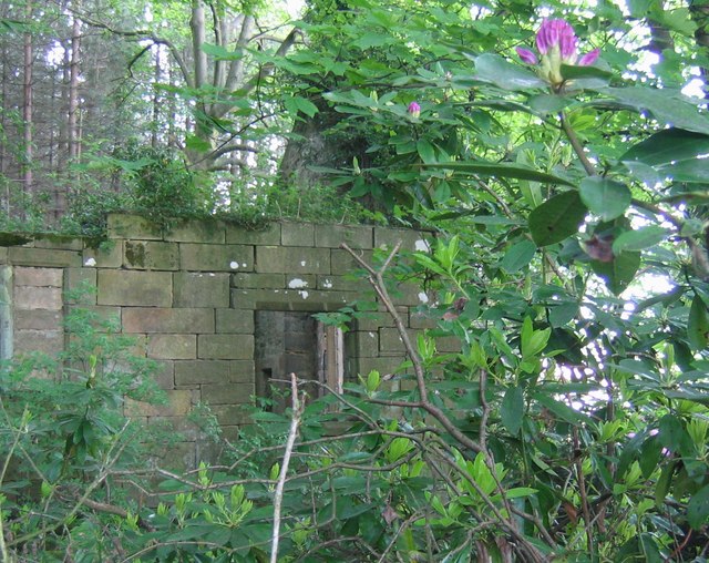
English: The ruin of Trinity Chapel, in the west of Brackenfield civil parish, Derbyshire, England |
| Date | |
| Source | From geograph.org.uk |
| Author | Nikki Mahadevan |
| Attribution (required by the license) | Nikki Mahadevan / Ruins of Trinity Chapel / |
| Object location | | View this and other nearby images on: OpenStreetMap |
|---|
_heading:90.00&language=en)
Licensing
[edit]

|
This image was taken from the Geograph project collection. See this photograph's page on the Geograph website for the photographer's contact details. The copyright on this image is owned by Nikki Mahadevan and is licensed for reuse under the Creative Commons Attribution-ShareAlike 2.0 license.
|
This file is licensed under the Creative Commons Attribution-Share Alike 2.0 Generic license.
Attribution: Nikki Mahadevan
- You are free:
- to share – to copy, distribute and transmit the work
- to remix – to adapt the work
- Under the following conditions:
- attribution – You must give appropriate credit, provide a link to the license, and indicate if changes were made. You may do so in any reasonable manner, but not in any way that suggests the licensor endorses you or your use.
- share alike – If you remix, transform, or build upon the material, you must distribute your contributions under the same or compatible license as the original.
File history
Click on a date/time to view the file as it appeared at that time.
| Date/Time | Thumbnail | Dimensions | User | Comment | |
|---|---|---|---|---|---|
| current | 15:16, 31 January 2010 | | 640 × 508 (133 KB) | GeographBot (talk | contribs) | == {{int:filedesc}} == {{Information |description={{en|1=Ruins of Trinity Chapel. Trinity Chapel was built around 1500 but now lies in ruins, hidden by trees. A new parish church, dedicated to the Holy Trinity, was built in Brackenfield in 1857 14812. |
You cannot overwrite this file.
File usage on Commons
The following page uses this file:
- File:Ruins of Trinity Chapel - geograph.org.uk - 179966.jpg (file redirect)
File usage on other wikis
The following other wikis use this file:
- Usage on en.wikipedia.org