File:Ruins of Carman Cottage - geograph.org.uk - 1220786.jpg
Ruins_of_Carman_Cottage_-_geograph.org.uk_-_1220786.jpg (640 × 480 pixels, file size: 126 KB, MIME type: image/jpeg)
Captions
Captions
Summary
[edit]
| Description |
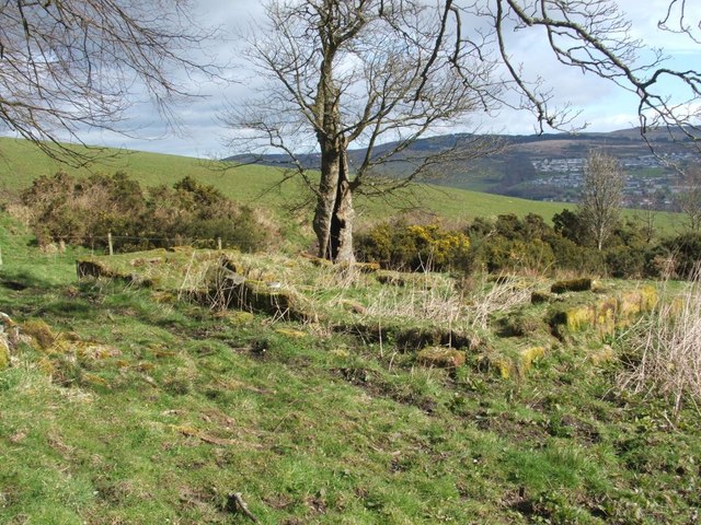
English: Ruins of Carman Cottage. For an indication of the date of construction of the building, and of its probable use, see an entry at WoSAS: http://www.wosas.net/wosas_site.php?id=21373
This rectangular ruin is made up of large blocks of red and grey sandstone. By pacing out the walls; I found that the ruin measures about 9.3 m by 5.1 m; see also 1220808, which shows one of the shorter walls of the same ruin. I later found that the building is named as Carman Cottage on old OS maps. [The WoSAS database entry suggests that it may have been a herdsman's house dating from the eighteenth century. Local tradition agrees: by coincidence, a few weeks after taking this photo, I was watching the video "The Lovely Valley – Memories of the Old Vale – Part 3", which contains local footage filmed from the 1950s to the 1970s; it concludes with a walk uphill, past the nearby stile – https://www.geograph.org.uk/photo/1220747 – which was described as being "at the shepherd's cottage".] On the other side of the fence behind the ruin is Poachy Glen, marked out by the trees and bushes that grow in abundance along the course of the Poachy Burn. There is another ruined structure in this area, but it is much less visible: 1224662. [The name Poachy Glen has nothing to do with poaching. In the book "Changing Identities, Ancient Roots – The History of West Dunbartonshire from Earliest Times", Simon Taylor cites a fourteenth-century land-grant that mentions "Poachy Burn (Pocheburne, probably containing Scots poch 'poach', a kind of fish)".] |
| Date | |
| Source | From geograph.org.uk |
| Author | Lairich Rig |
| Attribution (required by the license) | Lairich Rig / Ruins of Carman Cottage / |
| Camera location | | View this and other nearby images on: OpenStreetMap |
|---|
_heading:67.00&language=en)
| Object location | | View this and other nearby images on: OpenStreetMap |
|---|
_heading:67.00&language=en)
Licensing
[edit]

|
This image was taken from the Geograph project collection. See this photograph's page on the Geograph website for the photographer's contact details. The copyright on this image is owned by Lairich Rig and is licensed for reuse under the Creative Commons Attribution-ShareAlike 2.0 license.
|
- You are free:
- to share – to copy, distribute and transmit the work
- to remix – to adapt the work
- Under the following conditions:
- attribution – You must give appropriate credit, provide a link to the license, and indicate if changes were made. You may do so in any reasonable manner, but not in any way that suggests the licensor endorses you or your use.
- share alike – If you remix, transform, or build upon the material, you must distribute your contributions under the same or compatible license as the original.
File history
Click on a date/time to view the file as it appeared at that time.
| Date/Time | Thumbnail | Dimensions | User | Comment | |
|---|---|---|---|---|---|
| current | 10:48, 26 February 2011 | | 640 × 480 (126 KB) | GeographBot (talk | contribs) | == {{int:filedesc}} == {{Information |description={{en|1=Ruins of Carman Cottage For an indication of the date of construction of the building, and of its probable use, see an entry at WoSAS: http://www.wosas.net/wosas_site.php?id=21373 This rectangula |
You cannot overwrite this file.
File usage on Commons
There are no pages that use this file.