File:Ruanda Prov 1912 B002a.png
Jump to navigation
Jump to search

Size of this preview: 608 × 599 pixels. Other resolutions: 244 × 240 pixels | 487 × 480 pixels | 779 × 768 pixels | 1,039 × 1,024 pixels | 1,845 × 1,818 pixels.
Original file (1,845 × 1,818 pixels, file size: 946 KB, MIME type: image/png)
Captions
Captions
Add a one-line explanation of what this file represents
| Description |
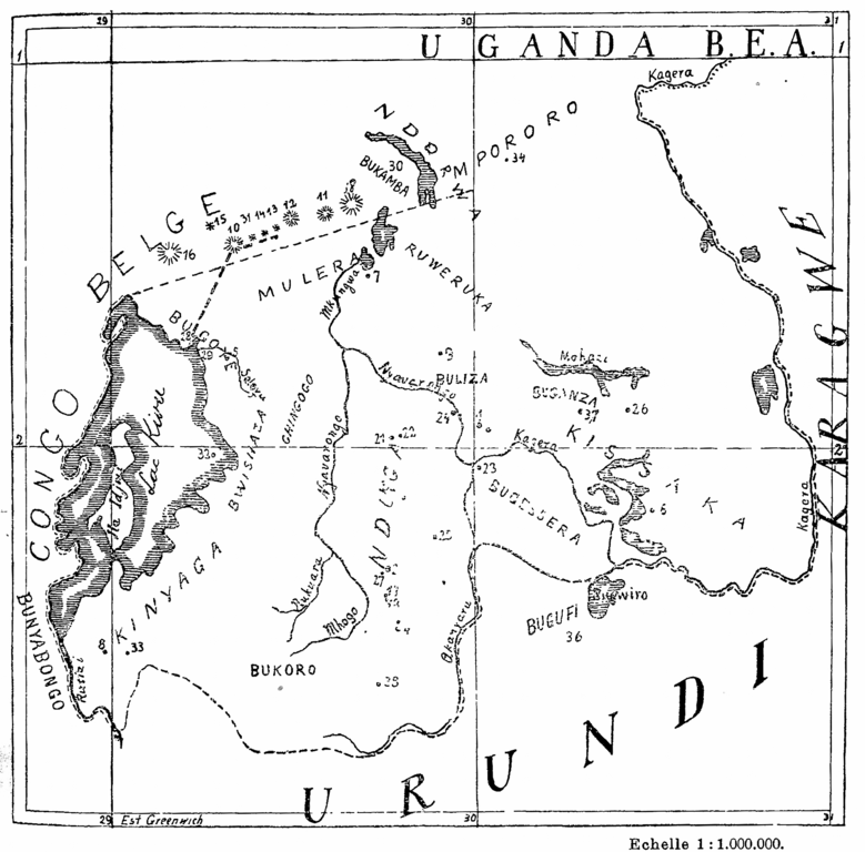
English: Map of the Ruanda area of the then German colony "German East Africa" with important lakes, provinces and localities mentionned in the given article
Français : Original caption: "
Carte du Ruanda où sont indiqués le noms des provinces et des localités cités dans cet article "Deutsch: Karte des Ruanda-Gebiets der damaligen Kolonie Deutsch-Ostafrika mit wichtigen Seen, Provinzen und Örtlichkeiten, sofern diese im oben genannten Artikel erwähnt werden |
||||
| Date | |||||
| Source | Alexandre Arnoux, "Le Culte de la Société Secrète des Imandwa au Ruanda", In: Anthropos (St.Gabriel-Mödling bei Wien), vol.7, No.3, 1912, p.273ff. | ||||
| Author | Alexandre Arnoux (Padre de Pères Blancs en Kabgayi) | ||||
| Permission (Reusing this file) |
|
||||
B.E.A. = British East Africa
Français : Aux nombres dans la carte (original):
1: Kigáli; 2: Nánza; 3: Kabgáyi; 4: Isávi; 5: Núndo; 6: Nzáza; 7: Ruáza; 8 Mibirizi; 9: Ruhindo: 10: Karisimbi, volcan; 11: Kahinga, id.; 12: Sabino, id.; 13: Segéša, id.; 14: Ndéndule, id.; 15: Múkurumúbi, id.; 16: Niragongo; 17: Burágurabána; 18: Bihána; 19: Kitisi; 20: Ku Runšúnšu; 21: Muzirángegera; 22: Akákibogo; 23 Kúli kágono; 24: Ngamba; 25: Mášoza ya Kimana; 26: Kwa širangabo; 27: Muširarungu; 28: Ngowa, Cong.B.; 29: Kisenyi; 30: Bukambo; 31: Bisóko; 31: Bisòko; 32: Intémbabagóyi; 33: Sources d'eau chaude; 34: Kwa Nirakahúmuza; 35: Mwúlire; 36 Buzégezege bgo harúguru; 37: Kimámagana; 38: Naruténgeli
1: Kigáli; 2: Nánza; 3: Kabgáyi; 4: Isávi; 5: Núndo; 6: Nzáza; 7: Ruáza; 8 Mibirizi; 9: Ruhindo: 10: Karisimbi, volcan; 11: Kahinga, id.; 12: Sabino, id.; 13: Segéša, id.; 14: Ndéndule, id.; 15: Múkurumúbi, id.; 16: Niragongo; 17: Burágurabána; 18: Bihána; 19: Kitisi; 20: Ku Runšúnšu; 21: Muzirángegera; 22: Akákibogo; 23 Kúli kágono; 24: Ngamba; 25: Mášoza ya Kimana; 26: Kwa širangabo; 27: Muširarungu; 28: Ngowa, Cong.B.; 29: Kisenyi; 30: Bukambo; 31: Bisóko; 31: Bisòko; 32: Intémbabagóyi; 33: Sources d'eau chaude; 34: Kwa Nirakahúmuza; 35: Mwúlire; 36 Buzégezege bgo harúguru; 37: Kimámagana; 38: Naruténgeli
File history
Click on a date/time to view the file as it appeared at that time.
| Date/Time | Thumbnail | Dimensions | User | Comment | |
|---|---|---|---|---|---|
| current | 13:41, 29 June 2016 | | 1,845 × 1,818 (946 KB) | Katharinaiv (talk | contribs) | {{Information |Description ={{en|1=Map of the Ruanda area of the then german colony "German East Africa" with important lakes, provinces and localities mentionned in the given article}} {{fr|1={{original caption|Carte du Ruanda où sond indiqués le... |
You cannot overwrite this file.
File usage on Commons
The following page uses this file:
File usage on other wikis
The following other wikis use this file:
- Usage on de.wikipedia.org
- Usage on en.wikipedia.org