File:Route Map 2.jpg
Jump to navigation
Jump to search
Size of this preview: 511 × 599 pixels. Other resolutions: 205 × 240 pixels | 409 × 480 pixels | 655 × 768 pixels | 873 × 1,024 pixels | 1,392 × 1,632 pixels.
Original file (1,392 × 1,632 pixels, file size: 943 KB, MIME type: image/jpeg)
Captions
Captions
Add a one-line explanation of what this file represents
Summary
[edit]
| Description |
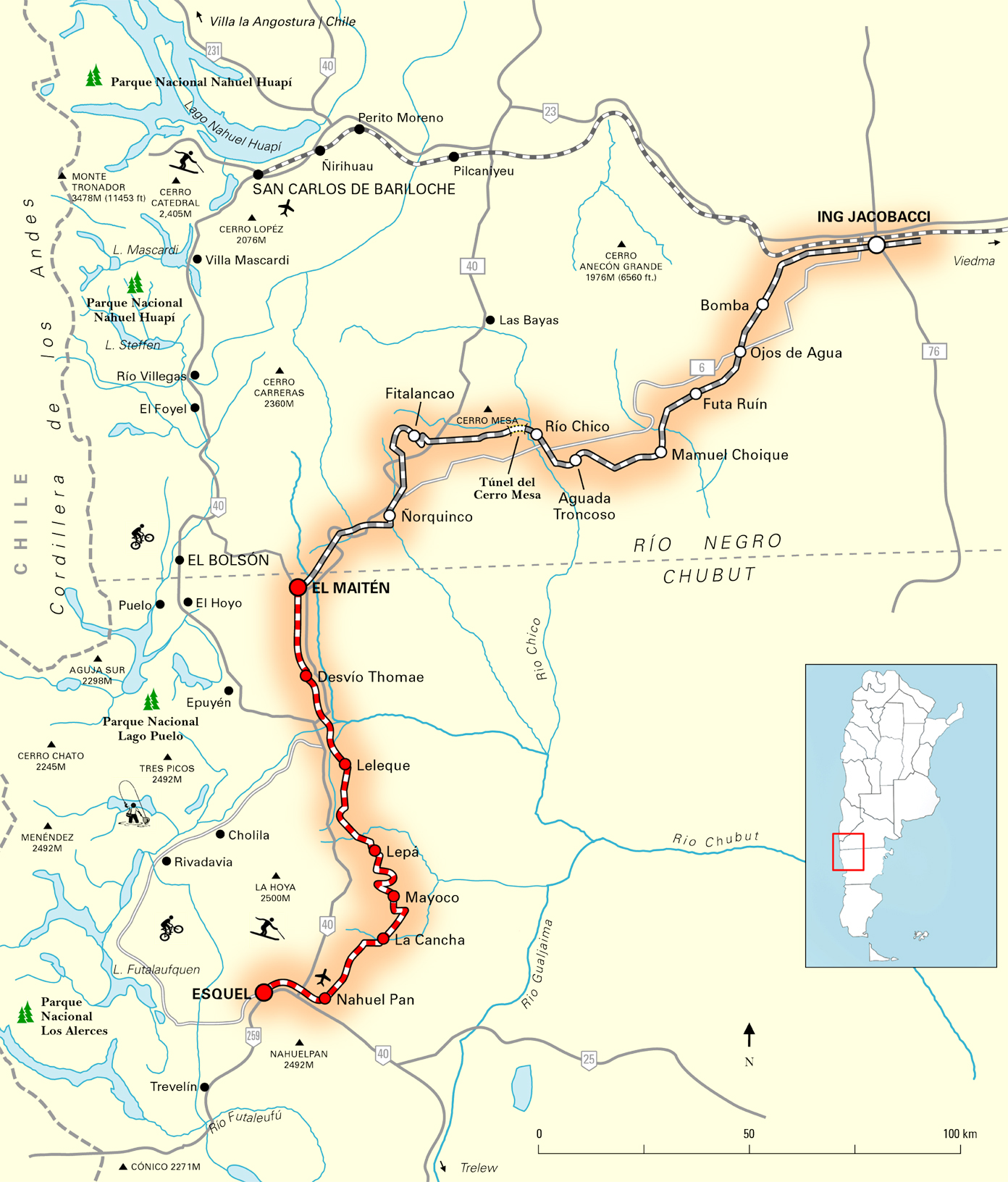
Español: Mapa del ferrocarril La Trochita (Expreso Patagónico)
English: Old Patagonian Express Route Map |
| Date | |
| Source |
Español: Mapa realizado en Adobe Illustrator y Photoshop en base a datos de dominio publico de Internet y vários atlas geográficos. Mapa Inspirado en los mapas de "Train Journeys of the World", ISBN 1 56619 207 2.
English: self-made. Inspired by the maps of "Train Journeys of the World" ISBN 1 56619 207 2. Map created in illustrator and photoshop from public domain data information obtained from several internet sources and printed Atlases. |
| Author | Moebiusuibeom-en (talk) |
Licensing
[edit]
User:Moebiusuibeom-en, the copyright holder of this work, hereby publishes it under the following licenses:
This file is licensed under the Creative Commons Attribution-Share Alike 3.0 Unported license.
Attribution: User:Moebiusuibeom-en
- You are free:
- to share – to copy, distribute and transmit the work
- to remix – to adapt the work
- Under the following conditions:
- attribution – You must give appropriate credit, provide a link to the license, and indicate if changes were made. You may do so in any reasonable manner, but not in any way that suggests the licensor endorses you or your use.
- share alike – If you remix, transform, or build upon the material, you must distribute your contributions under the same or compatible license as the original.

|
Permission is granted to copy, distribute and/or modify this document under the terms of the GNU Free Documentation License, Version 1.2 or any later version published by the Free Software Foundation; with no Invariant Sections, no Front-Cover Texts, and no Back-Cover Texts. A copy of the license is included in the section entitled GNU Free Documentation License. |
You may select the license of your choice.
Original upload log
[edit]
Transferred from en.wikipedia to Commons using For the Common Good.
The original description page was here. All following user names refer to en.wikipedia.
| Date/Time | Dimensions | User | Comment |
|---|---|---|---|
| 20:05, 4 March 2008 | 1,392 × 1,632 (965,124 bytes) | w:en:Moebiusuibeom-en (talk | contribs) | ({{Information |Description= '''Es: '''Mapa del ferrocarril La Trochita (Expreso Patagónico) '''En: '''Old Patagonian Express Route Map |Source='''Es:''' Mapa realizado en Adobe Illustrator y Photoshop en base a datos de dominio publico de Internet) |
File history
Click on a date/time to view the file as it appeared at that time.
| Date/Time | Thumbnail | Dimensions | User | Comment | |
|---|---|---|---|---|---|
| current | 19:23, 21 April 2013 | | 1,392 × 1,632 (943 KB) | Fredlyfish4 (talk | contribs) | Transferred from en.wikipedia: see original upload log above |
You cannot overwrite this file.
File usage on Commons
The following 2 pages use this file:
- File:Route Map 2 .jpg (file redirect)
- Category:La Trochita
File usage on other wikis
The following other wikis use this file:
- Usage on ar.wikipedia.org
- Usage on de.wikipedia.org
- Usage on en.wikipedia.org
- Usage on es.wikipedia.org
- Usage on ja.wikipedia.org
- Usage on lt.wikipedia.org
- Usage on ru.wikipedia.org
- Usage on sl.wikipedia.org
- Usage on www.wikidata.org