File:Rothenburger Landhege (1537).jpg
Jump to navigation
Jump to search

Size of this preview: 605 × 599 pixels. Other resolutions: 242 × 240 pixels | 485 × 480 pixels | 776 × 768 pixels | 1,034 × 1,024 pixels | 1,551 × 1,536 pixels.
Original file (1,551 × 1,536 pixels, file size: 817 KB, MIME type: image/jpeg)
Captions
Captions
Add a one-line explanation of what this file represents
Summary
[edit].jpg&action=edit§ion=1)
| Description |
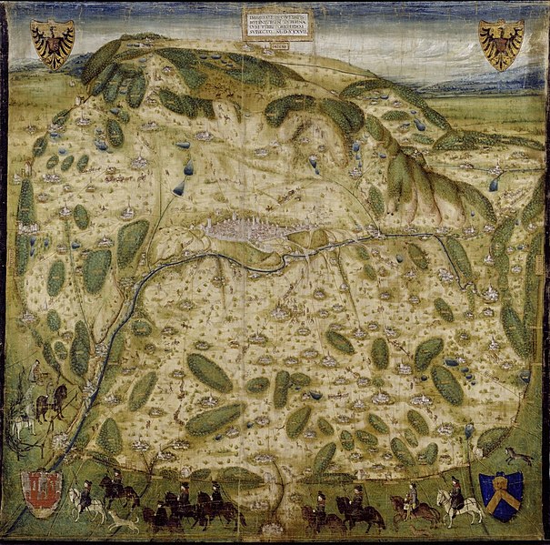
Deutsch: Gebiet (Landwehr) mit Dörfern der Freien Reichsstadt Rothenburg ob der Tauber. Karte von Wilhelm Ziegler, 1537. |
| Date | |
| Source | http://objektkatalog.gnm.de/objekt/La4040 |
| Author | Wilhelm Ziegler |
Licensing
[edit].jpg&action=edit§ion=2)
|
This is a faithful photographic reproduction of a two-dimensional, public domain work of art. The work of art itself is in the public domain for the following reason:
The official position taken by the Wikimedia Foundation is that "faithful reproductions of two-dimensional public domain works of art are public domain".
This photographic reproduction is therefore also considered to be in the public domain in the United States. In other jurisdictions, re-use of this content may be restricted; see Reuse of PD-Art photographs for details. | ||||
File history
Click on a date/time to view the file as it appeared at that time.
| Date/Time | Thumbnail | Dimensions | User | Comment | |
|---|---|---|---|---|---|
| current | 13:55, 22 October 2022 | | 1,551 × 1,536 (817 KB) | Sir Iain (talk | contribs) | Higher Resolution and lighter, as per original source |
| 15:15, 8 November 2018 |  | 600 × 597 (167 KB) | Sir Iain (talk | contribs) | User created page with UploadWizard |
You cannot overwrite this file.
File usage on Commons
The following 3 pages use this file:
File usage on other wikis
The following other wikis use this file:
- Usage on de.wikipedia.org
- Usage on www.wikidata.org
.jpg&oldid=898010839)