File:Rosemount Plantation 04.jpg
Jump to navigation
Jump to search

Size of this preview: 800 × 556 pixels. Other resolutions: 320 × 222 pixels | 640 × 445 pixels | 1,024 × 711 pixels | 1,280 × 889 pixels | 2,560 × 1,778 pixels | 4,588 × 3,187 pixels.
Original file (4,588 × 3,187 pixels, file size: 2.23 MB, MIME type: image/jpeg)
Captions
Captions
Add a one-line explanation of what this file represents
| Description |
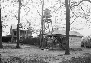
English: Rosemount, County Road 19, Forkland vicinity, Greene County, AL. SLAVE QUARTERS AT LEFT. (BURNED SUMMER 1934) EAST ELEVATION. WELL (ON RIGHT). |
|||||
| Date | ||||||
| Source |
Historic American Buildings Survey,Library of Congress, Prints & Photographs Division, HABS [or HAER or HALS], Reproduction number "HABS ALA,32-FORK.V,1-17"
|
|||||
| Author | W. N. Manning, Photographer | |||||
| Permission (Reusing this file) |
|


File history
Click on a date/time to view the file as it appeared at that time.
| Date/Time | Thumbnail | Dimensions | User | Comment | |
|---|---|---|---|---|---|
| current | 00:39, 27 March 2009 | | 4,588 × 3,187 (2.23 MB) | Martin H. (talk | contribs) | High res; cropped |
| 18:45, 24 November 2008 |  | 908 × 659 (443 KB) | Altairisfar (talk | contribs) | == Summary == {{Information |Description={{en|Rosemount, County Road 19, Forkland vicinity, Greene County, AL. SLAVE QUARTERS AT LEFT. (BURNED SUMMER 1934) EAST ELEVATION. WELL (ON RIGHT).}} |Source=Historic American Buildings Survey,Library of Congress, |
You cannot overwrite this file.
File usage on Commons
There are no pages that use this file.