File:Root traces in reddish sandstone (Upper Triassic; Jordan Lake, North Carolina, USA) 5.jpg

Original file (4,288 × 2,848 pixels, file size: 8.18 MB, MIME type: image/jpeg)
Captions
Captions
Summary
[edit]_5.jpg&action=edit§ion=1)
| Description |
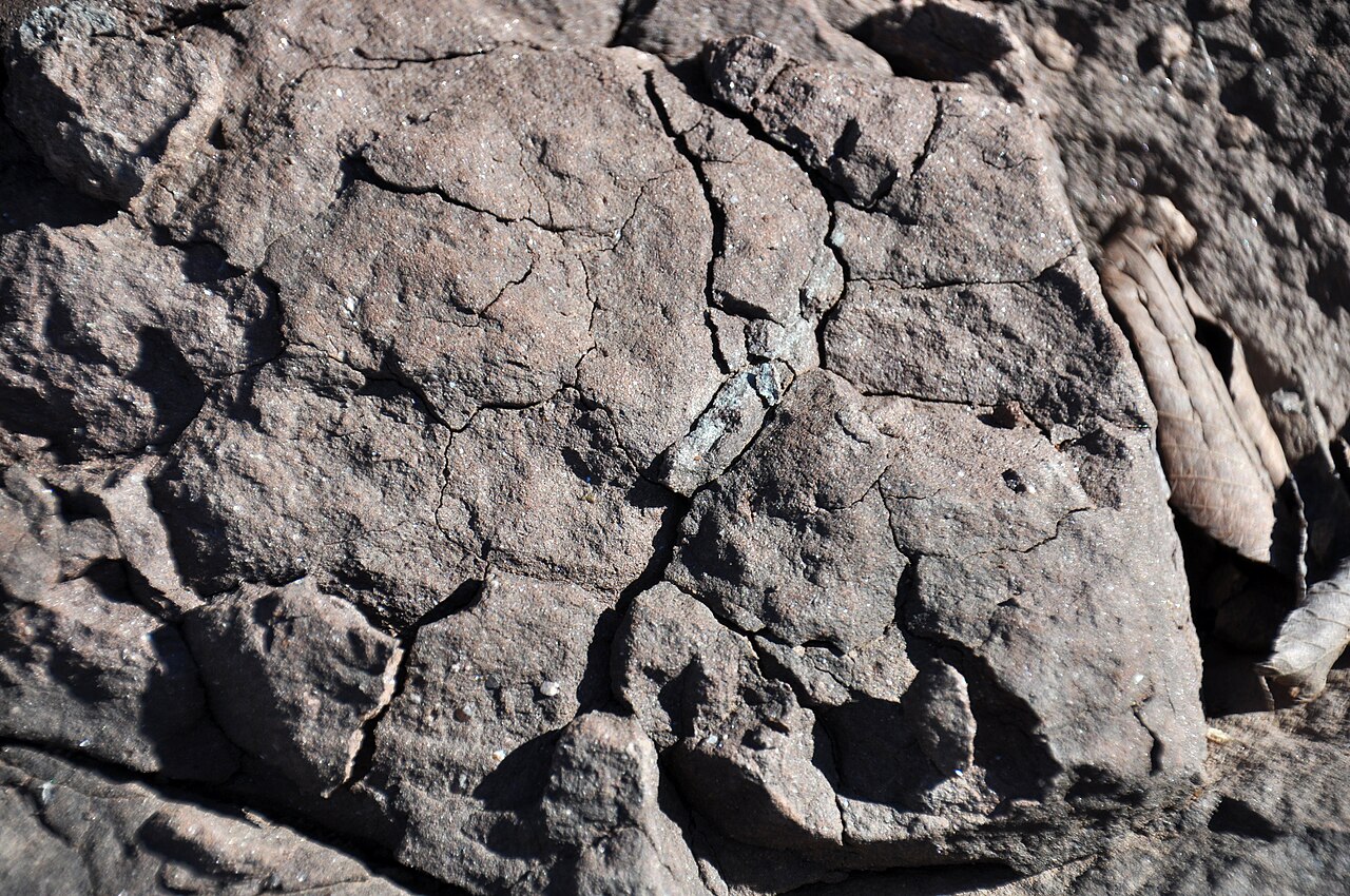
English: Fossil root traces in reddish sandstone in the Triassic of North Carolina, USA.
The Newark Supergroup is a thick, geographically-widespread stratigraphic unit in eastern America. It is Late Triassic to Early Jurassic in age and represents sediments and some lava flows that filled up old rift valleys roughly paralleling the modern-day Eastern Seaboard of America. The rift basins formed in the Triassic when the ancient Pangaea supercontinent attempted to break apart, but failed. A successful breakup of Pangaea occurred during the Jurassic. Most of the basin-filling rocks are terrestrial redbeds - hematite-rich siliciclastic sedimentary rocks, such as conglomerate, sandstone, siltstone, and shale, deposited in nonmarine environments. Seen here is a sandstone outcrop near the shoreline of Jordan Lake, a manmade reservoir in North Carolina. In Triassic rift basin terminology, this is part of the Durham Sub-Basin of the Deep River Basin. The sedimentary rocks of this area were originally dismissed as "undifferentiated Triassic". Droughts and low water levels have exposed novel outcrops along Jordan Lake's shoreline. No formation names are available, but the rocks are part of the Chatham Group. The stratigraphic terminology used in the nearby Sanford Sub-Basin is too simple, so "lithofacies association" terminology is used instead in the Durham Sub-Basin. The outcrop here is part of "lithofacies association 2", which consists of coarser-grained arkosic, micaceous, channel sandstones (not seen in this shot) topped by reddish-colored finer-grained, micaceous sandstones (seen here). Occasional greenish-colored mottles are present. Gleyed root traces in these rocks are somewhat greenish, making them easier to see. The root traces are paleosol horizons - at least two such horizons are here. The upper horizon of root traces appears truncated. Stratigraphy: Chatham Group, Newark Supergroup, Carnian to Norian Stages, Upper Triassic Locality: near-shoreline outcrop along the eastern side of Jordan Lake, a little north of the Jordan Lake visitor center & south of Route 65 & west-southwest of Wilsonville, eastern Chatham County, central North Carolina, USA (vicinity of 35° 44’ 04.40” North latitude, 79° 01’ 05.66” West longitude) See info. at: en.wikipedia.org/wiki/Newark_Supergroup |
| Date | |
| Source | https://www.flickr.com/photos/47445767@N05/51369277571/ |
| Author | James St. John |
Licensing
[edit]_5.jpg&action=edit§ion=2)
- You are free:
- to share – to copy, distribute and transmit the work
- to remix – to adapt the work
- Under the following conditions:
- attribution – You must give appropriate credit, provide a link to the license, and indicate if changes were made. You may do so in any reasonable manner, but not in any way that suggests the licensor endorses you or your use.
| This image was originally posted to Flickr by James St. John at https://flickr.com/photos/47445767@N05/51369277571. It was reviewed on 10 August 2021 by FlickreviewR 2 and was confirmed to be licensed under the terms of the cc-by-2.0. |
File history
Click on a date/time to view the file as it appeared at that time.
| Date/Time | Thumbnail | Dimensions | User | Comment | |
|---|---|---|---|---|---|
| current | 16:03, 10 August 2021 | | 4,288 × 2,848 (8.18 MB) | Ser Amantio di Nicolao (talk | contribs) | Uploaded a work by James St. John from https://www.flickr.com/photos/47445767@N05/51369277571/ with UploadWizard |
You cannot overwrite this file.
File usage on Commons
The following page uses this file:
_5_(51369277571).jpg&redirect=no)
_5.jpg&oldid=894988832)