File:Rogue Valley Inversion 2.jpg
Jump to navigation
Jump to search

Size of this preview: 798 × 141 pixels. Other resolutions: 320 × 57 pixels | 640 × 113 pixels | 1,024 × 181 pixels | 1,280 × 226 pixels | 2,560 × 453 pixels | 14,143 × 2,501 pixels.
Original file (14,143 × 2,501 pixels, file size: 11.97 MB, MIME type: image/jpeg)
Captions
Captions
Add a one-line explanation of what this file represents
Summary
[edit]
| Description |
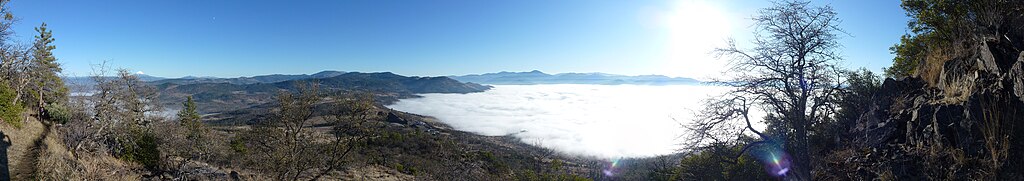
English: A temperature inversion in the Rogue Valley as seen from Roxy Ann Peak. The 3,576-foot (1,090 m) tall mountain rises over 2,000 feet (610 m) above the valley, and about 1,200 feet (370 m) above this particular fog layer, which formed in the cooler air mass below, while the warmer air mass above remained clear. These inversions can last for several weeks. |
| Date | |
| Source | Own work |
| Author | Little Mountain 5 |
| Camera location | | View this and other nearby images on: OpenStreetMap |
|---|
Licensing
[edit]
I, the copyright holder of this work, hereby publish it under the following license:
This file is licensed under the Creative Commons Attribution-Share Alike 3.0 Unported license.
- You are free:
- to share – to copy, distribute and transmit the work
- to remix – to adapt the work
- Under the following conditions:
- attribution – You must give appropriate credit, provide a link to the license, and indicate if changes were made. You may do so in any reasonable manner, but not in any way that suggests the licensor endorses you or your use.
- share alike – If you remix, transform, or build upon the material, you must distribute your contributions under the same or compatible license as the original.
| Annotations | This image is annotated: View the annotations at Commons |
File history
Click on a date/time to view the file as it appeared at that time.
| Date/Time | Thumbnail | Dimensions | User | Comment | |
|---|---|---|---|---|---|
| current | 02:51, 6 December 2011 | 14,143 × 2,501 (11.97 MB) | Little Mountain 5 (talk | contribs) |
You cannot overwrite this file.
File usage on Commons
There are no pages that use this file.
File usage on other wikis
The following other wikis use this file:
- Usage on en.wikipedia.org