File:Roer Triangle Map.jpg
Jump to navigation
Jump to search
No higher resolution available.
Roer_Triangle_Map.jpg (600 × 454 pixels, file size: 156 KB, MIME type: image/jpeg)
Captions
Captions
Add a one-line explanation of what this file represents
Summary
[edit]
| Description |
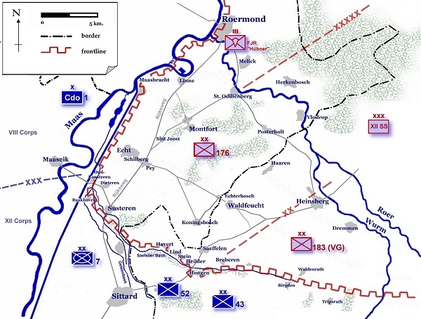
English: Map of the dispositions in the Roer Triangle, January 1945. |
| Date | 12 June 2006 (original upload date) |
| Source | Roer_Triangle_Map.jpg on English wikipedia |
| Author | The original uploader was Hgootzen at English Wikipedia. |
Licensing
[edit]
| This work has been released into the public domain by its author, Hgootzen. This applies worldwide. In some countries this may not be legally possible; if so: Hgootzen grants anyone the right to use this work for any purpose, without any conditions, unless such conditions are required by law.
|
Original upload log
[edit]
Transferred from en.wikipedia to Commons by Hans Erren using CommonsHelper.
The original description page was here. All following user names refer to en.wikipedia.
File history
Click on a date/time to view the file as it appeared at that time.
| Date/Time | Thumbnail | Dimensions | User | Comment | |
|---|---|---|---|---|---|
| current | 21:38, 11 February 2014 | | 600 × 454 (156 KB) | Hans Erren (talk | contribs) | copyright tag removed as PD |
| 21:18, 11 February 2014 |  | 600 × 454 (183 KB) | File Upload Bot (Magnus Manske) (talk | contribs) | Transfered from en.wikipedia by User:Hans Erren using CommonsHelper |
You cannot overwrite this file.
File usage on Commons
The following page uses this file:
File usage on other wikis
The following other wikis use this file:
- Usage on ca.wikipedia.org
- Usage on de.wikipedia.org
- Usage on en.wikipedia.org
- Usage on fr.wikipedia.org
- Usage on id.wikipedia.org
- Usage on it.wikipedia.org
- Usage on nl.wikipedia.org
- Usage on ta.wikipedia.org
- Usage on tr.wikipedia.org
- Usage on uk.wikipedia.org
- Usage on www.wikidata.org