File:RocPlat.jpg
Jump to navigation
Jump to search

Size of this preview: 800 × 600 pixels. Other resolutions: 320 × 240 pixels | 640 × 480 pixels | 1,024 × 768 pixels | 1,280 × 960 pixels | 2,560 × 1,920 pixels | 3,648 × 2,736 pixels.
Original file (3,648 × 2,736 pixels, file size: 2.05 MB, MIME type: image/jpeg)
Captions
Captions
Add a one-line explanation of what this file represents
Summary
[edit]
| Description |
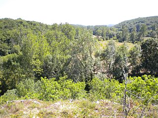
English: View from the iron age hillfort emplacement Roc Plat towards the SW into the Boulou valley. The hillfort was strategically positioned and surrounded by limestone cliffs dropping about 30 meters down to the valley floor. Commune of La Gonterie-Boulouneix, Dordogne, France.
Deutsch: Blick vom eisenzeitlichen Oppidum Roc Plat Richtung Südwest ins untere Bouloutal. Das Oppidum lag strategisch auf einer von Steilwänden umrahmten Anhöhe rund 30 Meter über dem Talboden. Gemeinde La Gonterie-Boulouneix, Dordogne, Frankreich.
Français : Vue du Roc Plat vers le sud-ouest (vallée du Boulou). Le Roc Plat était un oppidum du deuxième âge du fer sur un replat stratégique protégé par des falaises d'environ 30 mètres de hauteur. Commune de La Gonterie-Boulouneix, Dordogne, France. |
| Date | |
| Source | Own work |
| Author | Rudolf Pohl |
Licensing
[edit]
I, the copyright holder of this work, hereby publish it under the following licenses:
This file is licensed under the Creative Commons Attribution-Share Alike 3.0 Unported license.
- You are free:
- to share – to copy, distribute and transmit the work
- to remix – to adapt the work
- Under the following conditions:
- attribution – You must give appropriate credit, provide a link to the license, and indicate if changes were made. You may do so in any reasonable manner, but not in any way that suggests the licensor endorses you or your use.
- share alike – If you remix, transform, or build upon the material, you must distribute your contributions under the same or compatible license as the original.

|
Permission is granted to copy, distribute and/or modify this document under the terms of the GNU Free Documentation License, Version 1.2 or any later version published by the Free Software Foundation; with no Invariant Sections, no Front-Cover Texts, and no Back-Cover Texts. A copy of the license is included in the section entitled GNU Free Documentation License. |
You may select the license of your choice.
File history
Click on a date/time to view the file as it appeared at that time.
| Date/Time | Thumbnail | Dimensions | User | Comment | |
|---|---|---|---|---|---|
| current | 17:22, 26 June 2010 | | 3,648 × 2,736 (2.05 MB) | Rudolf Pohl (talk | contribs) | {{Information |Description={{en|1=View from the iron age hillfort emplacement Roc Plat towards the SW into the Boulou valley. The hillfort was strategically positioned and surrounded by limestone cliffs dropping about 30 meters down to the valley floor. C |
You cannot overwrite this file.
File usage on Commons
There are no pages that use this file.
File usage on other wikis
The following other wikis use this file:
- Usage on de.wikipedia.org