File:Road sign, forewarning of limitations on road Val Sanagra.jpg
Jump to navigation
Jump to search

Size of this preview: 800 × 367 pixels. Other resolutions: 320 × 147 pixels | 640 × 294 pixels | 1,024 × 470 pixels | 1,280 × 587 pixels | 3,934 × 1,805 pixels.
Original file (3,934 × 1,805 pixels, file size: 1.46 MB, MIME type: image/jpeg)
Captions
Captions
Add a one-line explanation of what this file represents
Summary
[edit]
| Description |
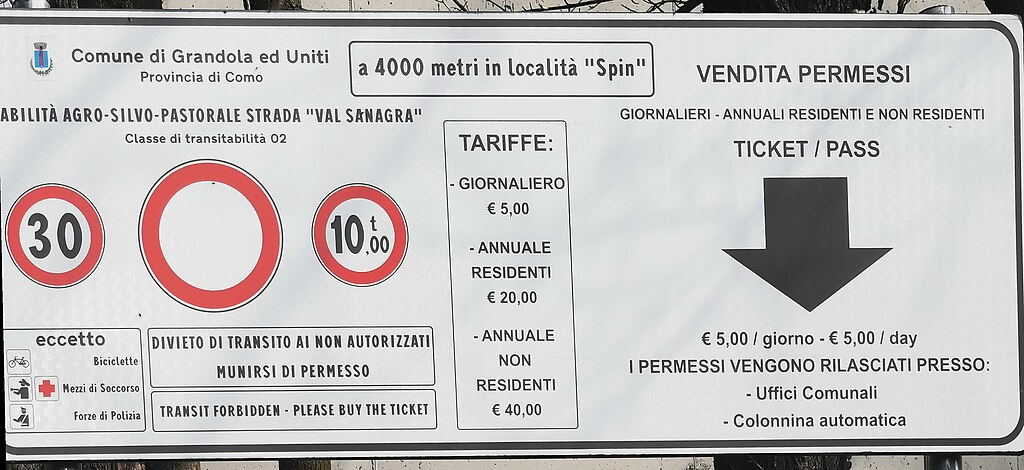
Italiano: Cartello di preavviso delle limitazioni al traffico sulla strada forestale Val Sanagra, a partire dalla località Spin. Posato lungo Via alle Alpi, in corrispondenza della colonnina automatica per la vendita dei permessi di transito. |
| Date | |
| Source | Own work |
| Author | Kaitu |
| Object location | | View this and other nearby images on: OpenStreetMap |
|---|
| Camera location | | View this and other nearby images on: OpenStreetMap |
|---|
|
Road sign, forewarning of limitations on road Val Sanagra.jpg has an entry on OpenStreetMap (show). |
Licensing
[edit]
I, the copyright holder of this work, hereby publish it under the following license:
This file is licensed under the Creative Commons Attribution-Share Alike 4.0 International license.
- You are free:
- to share – to copy, distribute and transmit the work
- to remix – to adapt the work
- Under the following conditions:
- attribution – You must give appropriate credit, provide a link to the license, and indicate if changes were made. You may do so in any reasonable manner, but not in any way that suggests the licensor endorses you or your use.
- share alike – If you remix, transform, or build upon the material, you must distribute your contributions under the same or compatible license as the original.
File history
Click on a date/time to view the file as it appeared at that time.
| Date/Time | Thumbnail | Dimensions | User | Comment | |
|---|---|---|---|---|---|
| current | 14:15, 12 May 2023 | | 3,934 × 1,805 (1.46 MB) | Kaitu (talk | contribs) | Uploaded own work with UploadWizard |
You cannot overwrite this file.
File usage on Commons
The following 2 pages use this file: