File:Road junction in Barrowford, Lancashire - geograph.org.uk - 776422.jpg
Jump to navigation
Jump to search
No higher resolution available.
Road_junction_in_Barrowford,_Lancashire_-_geograph.org.uk_-_776422.jpg (640 × 410 pixels, file size: 107 KB, MIME type: image/jpeg)
Captions
Captions
Add a one-line explanation of what this file represents
Summary
[edit]
| Description |
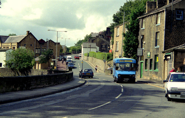
English: Road junction in Barrowford, Lancashire, near to Barrowford, Lancashire, Great Britain.
This shows the junction of Gisburn Road (main road, part of the A682) with Church Street (in the centre). The latter road gives access to the Pendleside villages such as Fence, Wheatley Lane and Higham, while the A682 gives a route from the A56 in Barrowford to the A59 at Gisburn. The blue minibus displays route number 66, destination: Blacko, a village about two miles away up the A682. |
| Date | |
| Source | From geograph.org.uk; transferred by User:Skinsmoke using geograph_org2commons. |
| Author | Dr Neil Clifton |
| Permission (Reusing this file) |
Creative Commons Attribution Share-alike license 2.0 |
| Attribution (required by the license) | Dr Neil Clifton / Road junction in Barrowford, Lancashire / |
| Camera location | | View this and other nearby images on: OpenStreetMap |
|---|
| Object location | | View this and other nearby images on: OpenStreetMap |
|---|
_region:GB-GBN_heading:202.00&language=en)
Licensing
[edit]

|
This image was taken from the Geograph project collection. See this photograph's page on the Geograph website for the photographer's contact details. The copyright on this image is owned by Dr Neil Clifton and is licensed for reuse under the Creative Commons Attribution-ShareAlike 2.0 license.
|
This file is licensed under the Creative Commons Attribution-Share Alike 2.0 Generic license.
Attribution: Dr Neil Clifton
- You are free:
- to share – to copy, distribute and transmit the work
- to remix – to adapt the work
- Under the following conditions:
- attribution – You must give appropriate credit, provide a link to the license, and indicate if changes were made. You may do so in any reasonable manner, but not in any way that suggests the licensor endorses you or your use.
- share alike – If you remix, transform, or build upon the material, you must distribute your contributions under the same or compatible license as the original.
File history
Click on a date/time to view the file as it appeared at that time.
| Date/Time | Thumbnail | Dimensions | User | Comment | |
|---|---|---|---|---|---|
| current | 21:45, 27 July 2010 | | 640 × 410 (107 KB) | File Upload Bot (Magnus Manske) (talk | contribs) | == {{int:filedesc}} == {{Information |Description={{en|1=Road junction in Barrowford, Lancashire, near to Barrowford, Lancashire, Great Britain. This shows the junction of Gisburn Road (main road, part of the A682) with Church Street (in the centre). The |
You cannot overwrite this file.
File usage on Commons
The following page uses this file:
File usage on other wikis
The following other wikis use this file:
- Usage on ceb.wikipedia.org
- Usage on en.wikipedia.org
- Usage on en.wikivoyage.org
- Usage on es.wikipedia.org
- Usage on it.wikipedia.org
- Usage on lld.wikipedia.org
- Usage on pl.wikipedia.org
- Usage on www.wikidata.org